
| Memorials | : | 2 |
| Location | : | Sand Brook, Hunterdon County, USA |
| Coordinate | : | 40.4803810, -74.9092480 |
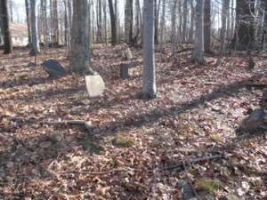
| Description | : | Kitchen Cemetery, Revisited Saturday, December 5, 2009 By Marfy Goodspeed Some time ago, I wrote an article on the Kitchen Family Burying Ground. It was published without pictures because I had been unable to visit the site. Well, that omission has been remedied. Recently I made that long-delayed visit and got some wonderful photos. Because it is important to put the photos with the names, I've decided to republish the article, with slight changes and photos attached. The cemetery is located near Routes 523 and 579, back from the roads, hiding in the woods. In 1931, Egbert T. Bush wrote that half of... Read More |
frequently asked questions (FAQ):
-
Where is Kitchen Cemetery?
Kitchen Cemetery is located at Rte 523 & Rte 579 Sand Brook, Hunterdon County ,New Jersey , 08822USA.
-
Kitchen Cemetery cemetery's updated grave count on graveviews.com?
2 memorials
-
Where are the coordinates of the Kitchen Cemetery?
Latitude: 40.4803810
Longitude: -74.9092480
Nearby Cemetories:
1. Sutton Farm Cemetery
Hunterdon County, USA
Coordinate: 40.4737206, -74.9048309
2. Trout Family Burying Ground
Sand Brook, Hunterdon County, USA
Coordinate: 40.4777778, -74.8972222
3. Sand Brook German Baptist Church Cemetery
Sand Brook, Hunterdon County, USA
Coordinate: 40.4687500, -74.9162216
4. Carmelite Monastery Cemetery
Flemington, Hunterdon County, USA
Coordinate: 40.4976610, -74.8980680
5. Rake Family Burying Ground
Sand Brook, Hunterdon County, USA
Coordinate: 40.4598999, -74.9170914
6. Valley School Cemetery
Hunterdon County, USA
Coordinate: 40.4981500, -74.8814430
7. Lower Amwell Cemetery - Old Yard
Sergeantsville, Hunterdon County, USA
Coordinate: 40.4479866, -74.9134750
8. Lower Amwell Cemetery - New Yard
Sergeantsville, Hunterdon County, USA
Coordinate: 40.4475098, -74.9133453
9. Moore Family Burying Ground
Sergeantsville, Hunterdon County, USA
Coordinate: 40.4414400, -74.9008720
10. Old Saint Magdalen Cemetery
Flemington, Hunterdon County, USA
Coordinate: 40.5075700, -74.8688100
11. Case Burial Ground
Flemington, Hunterdon County, USA
Coordinate: 40.5077770, -74.8658330
12. Opdycke Cemetery
Hunterdon County, USA
Coordinate: 40.4375000, -74.9250000
13. Prospect Hill Cemetery
Flemington, Hunterdon County, USA
Coordinate: 40.5135994, -74.8683014
14. Locktown Christian Cemetery
Locktown, Hunterdon County, USA
Coordinate: 40.4820137, -74.9694443
15. Pine Hill Cemetery
Sergeantsville, Hunterdon County, USA
Coordinate: 40.4580498, -74.9622192
16. Flemington Jewish Community Cemetery
Flemington, Hunterdon County, USA
Coordinate: 40.5127220, -74.8658829
17. Geary Gravesite
Amwell, Hunterdon County, USA
Coordinate: 40.4561386, -74.8564301
18. Flemington Baptist Churchyard
Flemington, Hunterdon County, USA
Coordinate: 40.5058327, -74.8572235
19. Saint Andrews Episcopal Churchyard
Ringoes, Hunterdon County, USA
Coordinate: 40.4406586, -74.8734360
20. Old School Baptist Cemetery
Locktown, Hunterdon County, USA
Coordinate: 40.4844290, -74.9725060
21. Sergeantville Methodist Episcopal Church Cemetery
Sergeantsville, Hunterdon County, USA
Coordinate: 40.4458333, -74.9538880
22. Saint Magdalen Cemetery
Flemington, Hunterdon County, USA
Coordinate: 40.5174500, -74.8668250
23. Flemington Presbyterian Church Cemetery
Flemington, Hunterdon County, USA
Coordinate: 40.5141500, -74.8595750
24. Servis-Quick Family Cemetery
Ringoes, Hunterdon County, USA
Coordinate: 40.4375000, -74.8722220