
| Memorials | : | 0 |
| Location | : | Watson, Atchison County, USA |
| Coordinate | : | 40.4917400, -95.5440620 |
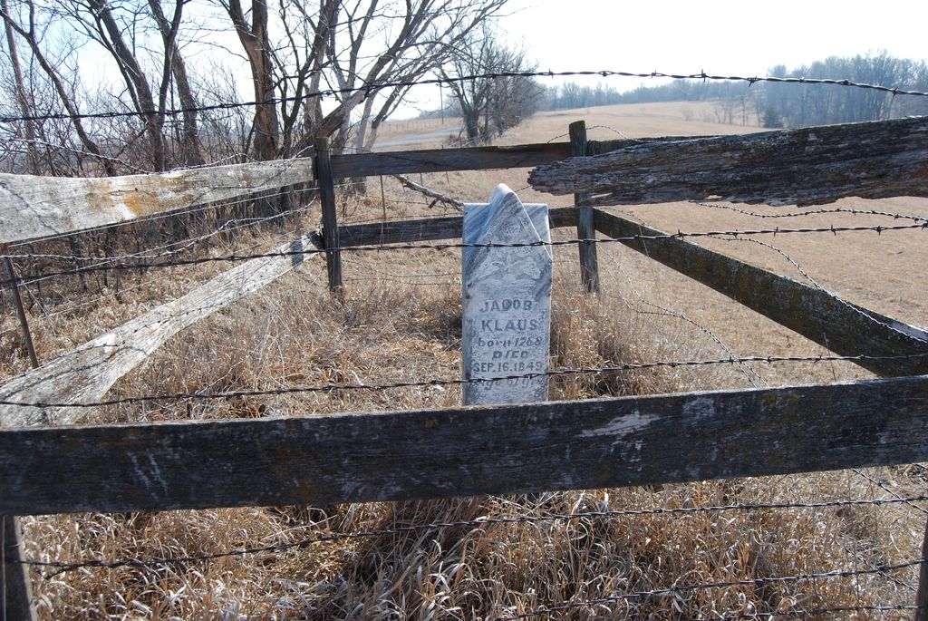
| Description | : | This is a private burial site located on private property in Section 34, Township 66, Range 41 Polk Township, Atchison County, Missouri. It is located in a pasture along the south side of Geneva Road about 1/2 mile north west of the Linden Cemetery. It is enclosed with a fence. |
frequently asked questions (FAQ):
-
Where is Klaus Burial Site?
Klaus Burial Site is located at Watson, Atchison County ,Missouri ,USA.
-
Klaus Burial Site cemetery's updated grave count on graveviews.com?
0 memorials
-
Where are the coordinates of the Klaus Burial Site?
Latitude: 40.4917400
Longitude: -95.5440620
Nearby Cemetories:
1. Linden Cemetery
Watson, Atchison County, USA
Coordinate: 40.4856130, -95.5383220
2. Clipfield Family Cemetery
Linden, Atchison County, USA
Coordinate: 40.4925560, -95.5313590
3. Stoner Cemetery
Atchison County, USA
Coordinate: 40.5127983, -95.5618973
4. High Creek Cemetery
Rock Port, Atchison County, USA
Coordinate: 40.5086780, -95.5690380
5. Addington Cemetery
Watson, Atchison County, USA
Coordinate: 40.4721985, -95.5828018
6. Kinser Burial Site
Watson, Atchison County, USA
Coordinate: 40.4974350, -95.5908610
7. Grange Hall Cemetery
Rock Port, Atchison County, USA
Coordinate: 40.5311012, -95.4863968
8. Smith Cemetery
Rock Port, Atchison County, USA
Coordinate: 40.4375000, -95.5028000
9. Clayton-Lewis Cemetery
Rock Port, Atchison County, USA
Coordinate: 40.5439730, -95.6102280
10. Lansdown family burial site
Rock Port, Atchison County, USA
Coordinate: 40.4154319, -95.5522575
11. County Home Cemetery
Rock Port, Atchison County, USA
Coordinate: 40.4180310, -95.5163740
12. Millsap Cemetery
Rock Port, Atchison County, USA
Coordinate: 40.4150009, -95.5532990
13. Greenhill Cemetery
Rock Port, Atchison County, USA
Coordinate: 40.4143982, -95.5074997
14. Sonora Cemetery
Watson, Atchison County, USA
Coordinate: 40.4730988, -95.6521988
15. Elmwood Cemetery
Rock Port, Atchison County, USA
Coordinate: 40.4062740, -95.5206080
16. Saint John's Church Cemetery
Atchison County, USA
Coordinate: 40.5382000, -95.4465000
17. Union Cemetery
Rock Port, Atchison County, USA
Coordinate: 40.5685000, -95.6110000
18. Mount Olive Cemetery
Hamburg, Fremont County, USA
Coordinate: 40.5938721, -95.5939484
19. Beehive Cemetery
Washington Township, Fremont County, USA
Coordinate: 40.5918740, -95.6087003
20. Honey Creek Cemetery
Nemaha Township, Nemaha County, USA
Coordinate: 40.4430199, -95.6980820
21. Walnut Grove Cemetery
Brownville, Nemaha County, USA
Coordinate: 40.4023056, -95.6642990
22. Hunter Cemetery
Rock Port, Atchison County, USA
Coordinate: 40.3636017, -95.5216980
23. Buckmiller Burial Site
Tarkio, Atchison County, USA
Coordinate: 40.4121111, -95.4033806
24. Mount Vernon Cemetery
Peru, Nemaha County, USA
Coordinate: 40.4768982, -95.7208023