
| Memorials | : | 1 |
| Location | : | Weinsberg, Landkreis Heilbronn, Germany |
| Coordinate | : | 49.7127330, 9.5481280 |
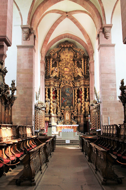
| Description | : | The Bronnbach cloister was founded by the Order of Cistercians in 1151. The cloister was dissolved in 1802 and its buildings are now being used by several institutions, including conference halls, a school, and several missionary foundations. In the cloister's church, named "Maria Himmelfahrt", one will find several graves of members of the Portuguese royal family as well as local dignitaries throughout the centuries. |
frequently asked questions (FAQ):
-
Where is Klosterkirche Bronnbach?
Klosterkirche Bronnbach is located at South of the city of Wertheim Weinsberg, Landkreis Heilbronn ,Baden-Württemberg ,Germany.
-
Klosterkirche Bronnbach cemetery's updated grave count on graveviews.com?
1 memorials
-
Where are the coordinates of the Klosterkirche Bronnbach?
Latitude: 49.7127330
Longitude: 9.5481280
Nearby Cemetories:
1. Pfarrkirche St. Laurentius in Uissigheim
Uissigheim, Main-Tauber-Kreis, Germany
Coordinate: 49.6794800, 9.5732600
2. Sachsenhausen Nordfriedhof
Sachsenhausen, Main-Tauber-Kreis, Germany
Coordinate: 49.7329959, 9.4917324
3. Jüdischer Friedhof Wertheim
Wertheim, Main-Tauber-Kreis, Germany
Coordinate: 49.7598800, 9.5236300
4. Evangelische Stiftskirche
Wertheim, Main-Tauber-Kreis, Germany
Coordinate: 49.7588890, 9.5175000
5. Bergfriedhof Wertheim
Wertheim, Main-Tauber-Kreis, Germany
Coordinate: 49.7587500, 9.5114600
6. Nassig Friedhof
Nassig, Main-Tauber-Kreis, Germany
Coordinate: 49.7378280, 9.4496690
7. Sonderriet Friedhof
Sonderriet, Main-Tauber-Kreis, Germany
Coordinate: 49.7189840, 9.4390620
8. Steinfurt Friedhof
Steinfurt, Main-Tauber-Kreis, Germany
Coordinate: 49.6470210, 9.4843450
9. Friedhof Neubrunn
Neubrunn bei Würzburg, Landkreis Würzburg, Germany
Coordinate: 49.7291660, 9.6704130
10. Friedhof Holzkirchhausen
Holzkirchhausen, Landkreis Würzburg, Germany
Coordinate: 49.7577057, 9.6676369
11. Friedhof Rettersheim
Rettersheim, Landkreis Main-Spessart, Germany
Coordinate: 49.8005077, 9.5858191
12. Friedhof Trennfeld
Trennfeld, Landkreis Main-Spessart, Germany
Coordinate: 49.7955771, 9.6160685
13. Friedhof Königheim
Königheim, Main-Tauber-Kreis, Germany
Coordinate: 49.6170233, 9.5909377
14. Friedhof Wenkheim
Wenkheim, Main-Tauber-Kreis, Germany
Coordinate: 49.6985380, 9.7045372
15. Jüdischer Friedhof Wenkheim
Wenkheim, Main-Tauber-Kreis, Germany
Coordinate: 49.7019912, 9.7179682
16. Friedhof Holzkirchen Unterfanken
Holzkirchen, Landkreis Würzburg, Germany
Coordinate: 49.7833220, 9.6822060
17. Friedhof Tauberbischofsheim
Tauberbischofsheim, Main-Tauber-Kreis, Germany
Coordinate: 49.6251332, 9.6571023
18. RuheForst Südspessart Stadtprozelten
Stadtprozelten, Landkreis Miltenberg, Germany
Coordinate: 49.7870383, 9.4156397
19. Saint Alban Catholic Church Cemetery
Hardheim, Neckar-Odenwald-Kreis, Germany
Coordinate: 49.6087700, 9.4745800
20. Friedhof Michelrieth
Michelrieth, Landkreis Main-Spessart, Germany
Coordinate: 49.8288681, 9.5231760
21. Friedhof Helmstadt
Helmstadt, Landkreis Würzburg, Germany
Coordinate: 49.7647975, 9.7109818
22. Friedhof Unteraltertheim
Unteraltertheim, Landkreis Würzburg, Germany
Coordinate: 49.7236721, 9.7354962
23. Jüdischer Friedhof Bad König
Bad König, Odenwaldkreis, Germany
Coordinate: 49.7449500, 9.3471000
24. Friedhof Remlingen
Remlingen, Landkreis Würzburg, Germany
Coordinate: 49.8066432, 9.6976671