
| Memorials | : | 0 |
| Location | : | Baron, Adair County, USA |
| Coordinate | : | 35.9107444, -94.6622000 |
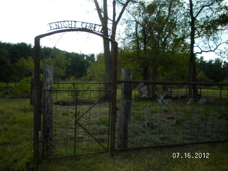
| Description | : | From "The Depot" in Stilwell, OK, take US Hwy 59 N, for 3.4 miles to England Hollow Road. Turn NW (left) and drive 4.7 miles to D761 Rd (Twin Bridges). Turn E (right), drive .01 mile to N4686 Rd. This is a private driveway. Cemetery is in the middle of the land owners pasture. You will need permission to access it. (Note: Some one has this cemetery "Googled" and labeled as 'Walkingstick Cemetery'. I personally went here and took these pictures. It IS Knight Cemetery.) There are so many unnamed, but marked, graves in... Read More |
frequently asked questions (FAQ):
-
Where is Knight Cemetery?
Knight Cemetery is located at Baron, Adair County ,Oklahoma , 74960USA.
-
Knight Cemetery cemetery's updated grave count on graveviews.com?
0 memorials
-
Where are the coordinates of the Knight Cemetery?
Latitude: 35.9107444
Longitude: -94.6622000
Nearby Cemetories:
1. Walkingstick Cemetery
Adair County, USA
Coordinate: 35.9108009, -94.6616974
2. Wolf Cemetery
Adair County, USA
Coordinate: 35.9166985, -94.6446991
3. Lincoln England Family Cemetery
Stilwell, Adair County, USA
Coordinate: 35.9274200, -94.6613600
4. Reese Cemetery
Adair County, USA
Coordinate: 35.8861008, -94.6430969
5. England Cemetery
Baron, Adair County, USA
Coordinate: 35.8818000, -94.6668000
6. Youngwolfe Cemetery
Christie, Adair County, USA
Coordinate: 35.9348090, -94.6828410
7. Thornton Cemetery
Addielee, Adair County, USA
Coordinate: 35.9378100, -94.6425280
8. Chewey Cemetery
Christie, Adair County, USA
Coordinate: 35.9285710, -94.6944440
9. Blackwood Cemetery
Stilwell, Adair County, USA
Coordinate: 35.8792000, -94.6481018
10. Terrell Cemetery
Adair County, USA
Coordinate: 35.8972400, -94.6231400
11. Ketcher Cemetery
Stilwell, Adair County, USA
Coordinate: 35.8758011, -94.6544037
12. Whitmire Cemetery
Christie, Adair County, USA
Coordinate: 35.9463889, -94.6641667
13. Easky Cemetery
Baron, Adair County, USA
Coordinate: 35.9018150, -94.6183280
14. Scraper Cemetery
Adair County, USA
Coordinate: 35.9131012, -94.7097015
15. Shell Cemetery
Stilwell, Adair County, USA
Coordinate: 35.8903021, -94.6201321
16. Clyne Cemetery
Baron, Adair County, USA
Coordinate: 35.9139400, -94.6053700
17. Downing Cemetery
Baron, Adair County, USA
Coordinate: 35.9271100, -94.6014100
18. Vaughn Family Cemetery
Sanders, Adair County, USA
Coordinate: 35.9014100, -94.7261800
19. Wilkerson Cemetery
Christie, Adair County, USA
Coordinate: 35.9618750, -94.6887990
20. Mulberry Hollow Cemetery
Adair County, USA
Coordinate: 35.8625000, -94.6995000
21. Tyler Spring Cemetery
Stilwell, Adair County, USA
Coordinate: 35.8460999, -94.6296997
22. Old Green Cemetery
Westville, Adair County, USA
Coordinate: 35.9770000, -94.6260000
23. Spade Mountain Cemetery
Spade Mountain, Adair County, USA
Coordinate: 35.8780000, -94.7420000
24. Corntassel Cemetery
Westville, Adair County, USA
Coordinate: 35.9815250, -94.6213310