
| Memorials | : | 0 |
| Location | : | Alliance, Stark County, USA |
| Coordinate | : | 40.9507600, -81.2050000 |
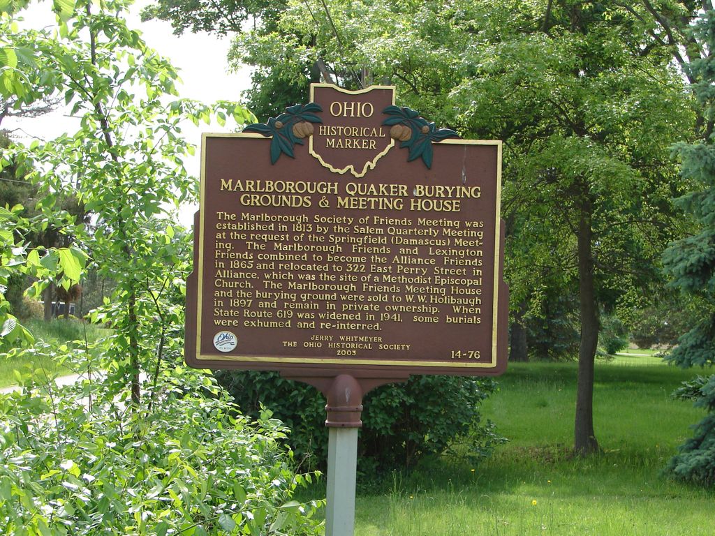
| Description | : | "The Marlborough Society of Friends Meeting was established in 1813 by the Salem Quarterly Meeting at the request of the Springfield (Damascus) Meeting. The Marlborough Friends and Lexington Friends combined to become the Alliance Friends in 1865 and relocated to 322 East Perry Street in Alliance, which was the site of a Methodist Episcopal Church. The Marlborough Friends Meeting House and the burying ground were sold to W.W. Holibaugh in 1897 and remain in private ownership. When State Route 619 was widened in 1941, some burials were exhumed and reinterred." - Remarkable Ohio, Marking Ohio's History, The Ohio Historical Society,... Read More |
frequently asked questions (FAQ):
-
Where is Marlborough Quaker Burying Grounds?
Marlborough Quaker Burying Grounds is located at 10053 Edison Street Alliance, Stark County ,Ohio , 44601USA.
-
Marlborough Quaker Burying Grounds cemetery's updated grave count on graveviews.com?
0 memorials
-
Where are the coordinates of the Marlborough Quaker Burying Grounds?
Latitude: 40.9507600
Longitude: -81.2050000
Nearby Cemetories:
1. Marlboro Cemetery
Marlboro, Stark County, USA
Coordinate: 40.9645025, -81.2145472
2. Saint Pauls Reform Church Cemetery
Marlboro, Stark County, USA
Coordinate: 40.9796700, -81.2130800
3. New Baltimore Cemetery
Stark County, USA
Coordinate: 40.9832993, -81.2360992
4. Science Hill Cemetery
Alliance, Stark County, USA
Coordinate: 40.9213930, -81.1639020
5. Deer Creek Quaker Cemetery
Stark County, USA
Coordinate: 40.9881020, -81.1722570
6. Wood Family Cemetery
Lexington, Stark County, USA
Coordinate: 40.9524870, -81.1407710
7. French Baptist Church Cemetery
Harrisburg, Stark County, USA
Coordinate: 40.9082790, -81.2406660
8. Limaville Cemetery
Stark County, USA
Coordinate: 40.9799995, -81.1500015
9. Saint Peters Cemetery
Stark County, USA
Coordinate: 40.9225000, -81.2630600
10. Baptist Cemetery
Harrisburg, Stark County, USA
Coordinate: 40.8953640, -81.2296320
11. Sacred Heart of Mary Cemetery
Harrisburg, Stark County, USA
Coordinate: 40.8913002, -81.2285995
12. Ringer Cemetery
Nimishillen Township, Stark County, USA
Coordinate: 40.8916460, -81.2393030
13. Lexington Quaker Cemetery
Lexington, Stark County, USA
Coordinate: 40.9617004, -81.1117020
14. Dutch-Old German Church Cemetery
Atwater, Portage County, USA
Coordinate: 40.9886020, -81.1243970
15. Alliance City Cemetery
Alliance, Stark County, USA
Coordinate: 40.9309998, -81.1129990
16. Saint Joseph Cemetery
Maximo, Stark County, USA
Coordinate: 40.8779411, -81.1721878
17. Dutch Church Cemetery
Alliance, Stark County, USA
Coordinate: 40.9305650, -81.1055320
18. Beech Mennonite Cemetery
Louisville, Stark County, USA
Coordinate: 40.8699989, -81.2106018
19. Atwater Cemetery
Atwater, Portage County, USA
Coordinate: 41.0203030, -81.1481420
20. Williamsport Cemetery
Alliance, Stark County, USA
Coordinate: 40.9325981, -81.0980988
21. Brumbaugh Cemetery
Hartville, Stark County, USA
Coordinate: 40.9752998, -81.3107986
22. West Beech Cemetery
Beechwood, Stark County, USA
Coordinate: 40.8860016, -81.1330032
23. Werner Chapel Cemetery
Middlebranch, Stark County, USA
Coordinate: 40.8959999, -81.3010025
24. Disciple Cemetery
Randolph, Portage County, USA
Coordinate: 41.0355988, -81.2489014