
| Memorials | : | 2 |
| Location | : | Moler Crossroads, Jefferson County, USA |
| Coordinate | : | 39.3672700, -77.7495100 |
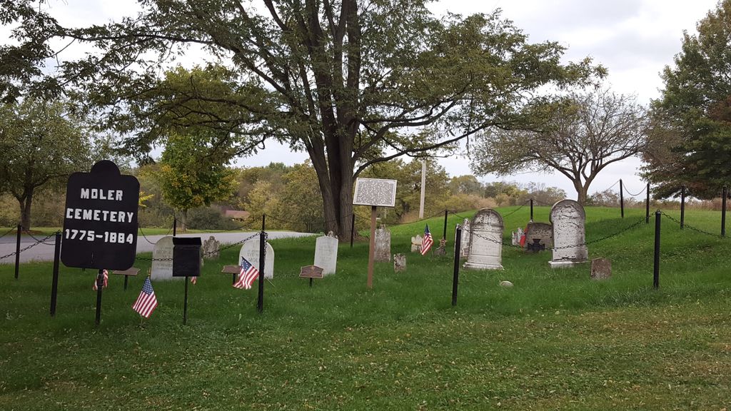
| Description | : | From the intersection of Highway 28 (Bakerton Road) and Highway 30 (Carter Avenue) east of Bakerton, drive 1/2 mile north on Bakerton Road to Morning Calm Lane and turn right. The cemetery is just 100 ft away, on the north side of Morning Calm Lane. From 1775 to 1884, this was the family cemetery for Michael Moler (c1758 - 1828) and his wife Mary (1770 - 1835), their children and families, located about 2 1/2 miles southeast of the settlement known as Moler Crossroads. |
frequently asked questions (FAQ):
-
Where is Moler Cemetery?
Moler Cemetery is located at Moler Crossroads, Jefferson County ,West Virginia ,USA.
-
Moler Cemetery cemetery's updated grave count on graveviews.com?
2 memorials
-
Where are the coordinates of the Moler Cemetery?
Latitude: 39.3672700
Longitude: -77.7495100
Nearby Cemetories:
1. Moler Cemetery
Bakerton, Jefferson County, USA
Coordinate: 39.3673700, -77.7496000
2. Flanegan Cemetery
Bakerton, Jefferson County, USA
Coordinate: 39.3750000, -77.7620000
3. Hageley Cemetery
Bakerton, Jefferson County, USA
Coordinate: 39.3641838, -77.7730423
4. Samples Manor Cemetery
Samples Manor, Washington County, USA
Coordinate: 39.3732262, -77.7216568
5. Duffield Colored Cemetery
Uvilla, Jefferson County, USA
Coordinate: 39.3603900, -77.7985600
6. Saint James Lutheran Church Cemetery
Uvilla, Jefferson County, USA
Coordinate: 39.3686104, -77.7995300
7. Uvilla Methodist Church Cemetery
Jefferson County, USA
Coordinate: 39.3660040, -77.7998030
8. Cedar Hill Cemetery
Harpers Ferry, Jefferson County, USA
Coordinate: 39.3283520, -77.7524420
9. Mount Zion AME Church Cemetery
Reedson, Jefferson County, USA
Coordinate: 39.3492120, -77.8001050
10. Harper Cemetery
Harpers Ferry, Jefferson County, USA
Coordinate: 39.3236847, -77.7345352
11. Saint Peter's Cemetery
Harpers Ferry, Jefferson County, USA
Coordinate: 39.3213806, -77.7480927
12. Fairview Lutheran Cemetery
Bolivar, Jefferson County, USA
Coordinate: 39.3215700, -77.7567500
13. Mount Moriah Baptist Church Cemetery
Washington County, USA
Coordinate: 39.3535995, -77.6908035
14. Renaud Cemetery
Moler Crossroads, Jefferson County, USA
Coordinate: 39.3970846, -77.7986351
15. Garrett's Mill Assemblies of God Cemetery
Garretts Mill, Washington County, USA
Coordinate: 39.3527184, -77.6881485
16. Moler Graveyard
Halltown, Jefferson County, USA
Coordinate: 39.3188400, -77.7739900
17. Payne's Hill Cemetery
Halltown, Jefferson County, USA
Coordinate: 39.3190730, -77.7810570
18. McGolenick-Phillips Cemetery
Garretts Mill, Washington County, USA
Coordinate: 39.3612300, -77.6793900
19. Virts Farm Cemetery
Sandy Hook, Washington County, USA
Coordinate: 39.3299675, -77.6966705
20. Allstadt Graveyard
Halltown, Jefferson County, USA
Coordinate: 39.3145270, -77.7732030
21. Lucas Family Cemetery at Elmwood
Shepherdstown, Jefferson County, USA
Coordinate: 39.3957200, -77.8149300
22. Norris Cemetery
Garretts Mill, Washington County, USA
Coordinate: 39.3463968, -77.6781411
23. Elk Branch Presbyterian Church Cemetery
Duffields, Jefferson County, USA
Coordinate: 39.3647614, -77.8279190
24. Ridenour Cemetery
Duffields, Jefferson County, USA
Coordinate: 39.3644414, -77.8280193