
| Memorials | : | 0 |
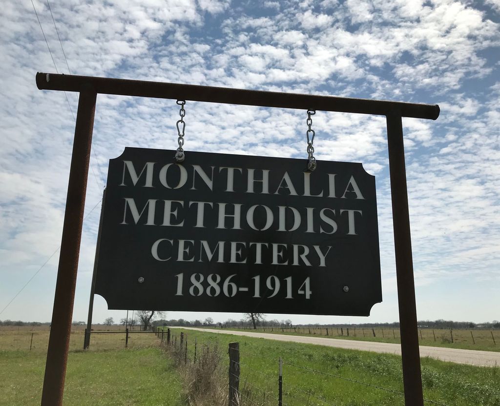
| Location | : | Monthalia, Gonzales County, USA |
| Coordinate | : | 29.4640000, -97.5878200 |
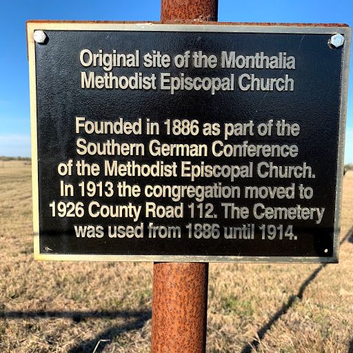
| Description | : | The Monthalia Methodist-Episcopal Church was organized with seventeen members in 1886; their first building was constructed in 1889 between Monthalia and Cost (State Highway 455); the property included the original cemetery. In 1913 the church was moved to its current location two miles south of Highway 466 on Church Rd; a new cemetery was opened. Later the church was renamed Monthalia United Methodist Church |
frequently asked questions (FAQ):
-
Where is Monthalia Methodist Cemetery?
Monthalia Methodist Cemetery is located at Monthalia, Gonzales County ,Texas ,USA.
-
Monthalia Methodist Cemetery cemetery's updated grave count on graveviews.com?
0 memorials
-
Where are the coordinates of the Monthalia Methodist Cemetery?
Latitude: 29.4640000
Longitude: -97.5878200
Nearby Cemetories:
1. Monthalia African American Cemetery
Monthalia, Gonzales County, USA
Coordinate: 29.4615840, -97.5849960
2. Monthalia Catholic Cemetery
Monthalia, Gonzales County, USA
Coordinate: 29.4648000, -97.5926430
3. Monthalia Catholic Cemetery, Mexican-American Side
Gonzales County, USA
Coordinate: 29.4638630, -97.5928890
4. Monthalia Lutheran Cemetery
Monthalia, Gonzales County, USA
Coordinate: 29.4683640, -97.6064700
5. Shuler Cemetery
Gonzales County, USA
Coordinate: 29.4675360, -97.5689110
6. Monthalia United Methodist Church Cemetery
Monthalia, Gonzales County, USA
Coordinate: 29.4358200, -97.5877560
7. King Cemetery
Oak Forest, Gonzales County, USA
Coordinate: 29.5044003, -97.5971985
8. Rossow Family Cemetery
Gonzales County, USA
Coordinate: 29.4209820, -97.5836710
9. Oso Cemetery
Gonzales County, USA
Coordinate: 29.4246998, -97.5569000
10. Hodge Cemetery
Gonzales County, USA
Coordinate: 29.5083008, -97.5578003
11. Liberty Cemetery
Gonzales County, USA
Coordinate: 29.4316998, -97.6374969
12. Foster Cemetery
Gonzales County, USA
Coordinate: 29.5160999, -97.6102982
13. Pecan Branch - Smith Cemetery
Gonzales, Gonzales County, USA
Coordinate: 29.4841995, -97.5252991
14. Dikes Family Cemetery
Cost, Gonzales County, USA
Coordinate: 29.4436530, -97.5227330
15. Dickinson Cemetery
Gonzales County, USA
Coordinate: 29.5096380, -97.6348330
16. Stroman Cemetery
Gonzales County, USA
Coordinate: 29.4547005, -97.6603012
17. Randle Cemetery
Oak Forest, Gonzales County, USA
Coordinate: 29.5293999, -97.5742035
18. Hood Point Negro Cemetery
Gonzales, Gonzales County, USA
Coordinate: 29.5392140, -97.5814860
19. Ellis Cemetery
Gonzales County, USA
Coordinate: 29.5396070, -97.5837010
20. Allen Family Cemetery
Belmont, Gonzales County, USA
Coordinate: 29.5104340, -97.6599060
21. Holmes Cemetery
Gonzales County, USA
Coordinate: 29.4293995, -97.6746979
22. Greenwood Cemetery
Gonzales, Gonzales County, USA
Coordinate: 29.5317001, -97.5302963
23. Ellis-Nance Cemetery
Gonzales County, USA
Coordinate: 29.4652996, -97.6868973
24. Askey Cemetery
Gonzales, Gonzales County, USA
Coordinate: 29.4477760, -97.4847550