
| Memorials | : | 6 |
| Location | : | Clay County, USA |
| Coordinate | : | 36.2737312, -90.3426285 |
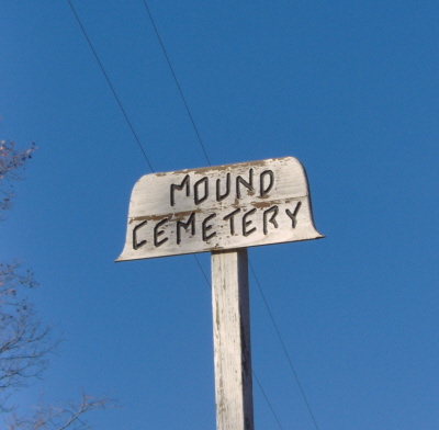
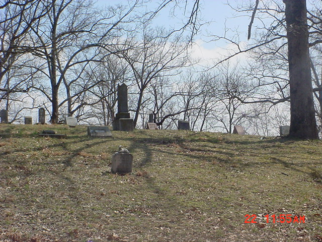
| Description | : | It's located West of Rector, Clay County,Arkansas. The Mound Cemetery sign is on the South side of road 417. Turn on the road right next to the sign. The cemetery is located at the end of the road up on a small hill. It's a very peaceful cemetery. The land the cemetery is located on was the homestead of Thomas Henry & Margaret Virginia {Young} Sides. Margaret Virginia Sides picked out a spot for her burial very early in her life. Upon her death in Jan.1914 she was brought back to Arkansas from Wichita Falls,Texas to be buried in what is known... Read More |
frequently asked questions (FAQ):
-
Where is Mound Cemetery?
Mound Cemetery is located at It's located 3 miles West of Rector, Clay County, Arkansas. Clay County ,Arkansas ,USA.
-
Mound Cemetery cemetery's updated grave count on graveviews.com?
6 memorials
-
Where are the coordinates of the Mound Cemetery?
Latitude: 36.2737312
Longitude: -90.3426285

Nearby Cemetories:
1. Parks Cemetery
Rector, Clay County, USA
Coordinate: 36.2619934, -90.3266754
2. Ebenezer Cemetery
Clay County, USA
Coordinate: 36.2887383, -90.3643570
3. Scatterville Cemetery
Rector, Clay County, USA
Coordinate: 36.2813683, -90.3131104
4. Pleasant Grove Cemetery
Hopewell, Greene County, USA
Coordinate: 36.2543983, -90.3630981
5. Shannon Cemetery
Clay County, USA
Coordinate: 36.2982483, -90.3639374
6. Woodland Heights Cemetery
Rector, Clay County, USA
Coordinate: 36.2724991, -90.3039017
7. Purcell Cemetery
Rector, Clay County, USA
Coordinate: 36.2602997, -90.3910980
8. Marys Chapel Cemetery
Rector, Clay County, USA
Coordinate: 36.2921982, -90.2830963
9. Salem Cemetery
Rector, Clay County, USA
Coordinate: 36.3208008, -90.3818970
10. Liberty Hill Cemetery
Boydsville, Clay County, USA
Coordinate: 36.3280983, -90.3182983
11. Blooming Grove Cemetery
Clay County, USA
Coordinate: 36.3147011, -90.2913971
12. Lone Grave
Clay County, USA
Coordinate: 36.3358002, -90.3331070
13. Johnson Chapel Cemetery
Clay County, USA
Coordinate: 36.3383900, -90.3572400
14. Cudd Cemetery
Marmaduke, Greene County, USA
Coordinate: 36.2202988, -90.3955994
15. Hillsboro Cemetery
Rector, Clay County, USA
Coordinate: 36.2975883, -90.2605820
16. Harveys Chapel Cemetery
Marmaduke, Greene County, USA
Coordinate: 36.2131004, -90.3906021
17. Bethlehem Cemetery
Clay County, USA
Coordinate: 36.2872009, -90.4393997
18. Travillian Cemetery
Clay County, USA
Coordinate: 36.3382988, -90.2842026
19. Rock Springs Cemetery
Knob, Clay County, USA
Coordinate: 36.2785988, -90.4439011
20. Mars Hill Cemetery
Crockett, Clay County, USA
Coordinate: 36.3624992, -90.3275604
21. Ramers Chapel Cemetery
Marmaduke, Greene County, USA
Coordinate: 36.2344590, -90.4426930
22. Starnes Cemetery
Greene County, USA
Coordinate: 36.2221080, -90.4371790
23. Hargrave Parish Church
Hargrave Corner, Clay County, USA
Coordinate: 36.2590598, -90.2290688
24. Leonard Cemetery
Leonard, Clay County, USA
Coordinate: 36.2164001, -90.2481003