
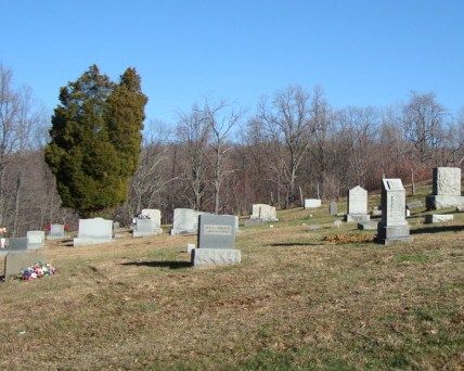
| Memorials | : | 69 |
| Location | : | Barbour County, USA |
| Coordinate | : | 39.1297120, -79.8924010 |
frequently asked questions (FAQ):
-
Where is Mount Zion Mill Run Cemetery?
Mount Zion Mill Run Cemetery is located at Barbour County ,West Virginia ,USA.
-
Mount Zion Mill Run Cemetery cemetery's updated grave count on graveviews.com?
69 memorials
-
Where are the coordinates of the Mount Zion Mill Run Cemetery?
Latitude: 39.1297120
Longitude: -79.8924010

Nearby Cemetories:
1. Central Chapel United Methodist Church Cemetery
Belington, Barbour County, USA
Coordinate: 39.1321300, -79.9160800
2. White Oak Cemetery
Barbour County, USA
Coordinate: 39.1454760, -79.9152490
3. Old White Oak Cemetery
Barbour County, USA
Coordinate: 39.1494010, -79.9108110
4. Little Bethel Church Cemetery
Meadowville, Barbour County, USA
Coordinate: 39.1146230, -79.9179040
5. Little Bethel Baptist Church Cemetery
Barbour County, USA
Coordinate: 39.1122500, -79.9274400
6. Mount Zion Church of The Brethren Cemetery
Meadowville, Barbour County, USA
Coordinate: 39.1720670, -79.8625520
7. Cross Roads Cemetery
Barbour County, USA
Coordinate: 39.1652940, -79.9419340
8. Marsh Cemetery
Tacy, Barbour County, USA
Coordinate: 39.1663710, -79.9410510
9. Joseph Chapel Cemetery
Belington, Barbour County, USA
Coordinate: 39.0955220, -79.9466940
10. Lambert Chapel Cemetery
Belington, Barbour County, USA
Coordinate: 39.0765550, -79.9119050
11. Nestorville Cemetery
Barbour County, USA
Coordinate: 39.1865020, -79.9111950
12. Saint John Cemetery
Barbour County, USA
Coordinate: 39.1850890, -79.9419250
13. New Hope Cemetery
Valley Furnace, Barbour County, USA
Coordinate: 39.1966040, -79.8787540
14. Sugar Creek Cemetery
Belington, Barbour County, USA
Coordinate: 39.0610840, -79.9218200
15. Mount Castle Cemetery
Valley Furnace, Barbour County, USA
Coordinate: 39.2019870, -79.8629650
16. Mount Pleasant Cemetery
Saint George, Tucker County, USA
Coordinate: 39.1197590, -79.7947820
17. Campbell Cemetery
Nestorville, Barbour County, USA
Coordinate: 39.2059960, -79.8860070
18. Harsh Cemetery
Saint George, Tucker County, USA
Coordinate: 39.1197290, -79.7946770
19. Old Dutch Cemetery
Nestorville, Barbour County, USA
Coordinate: 39.2069540, -79.8893020
20. Olive Hill Cemetery
Barbour County, USA
Coordinate: 39.1533012, -79.9906006
21. New Hope Cemetery
Parsons, Tucker County, USA
Coordinate: 39.1591000, -79.7961000
22. Silent Grove Cemetery
Barbour County, USA
Coordinate: 39.1256730, -80.0021410
23. Silent Grove Cemetery
Philippi, Barbour County, USA
Coordinate: 39.1259617, -80.0022289
24. Primitive Baptist Church Cemetery
Montrose, Randolph County, USA
Coordinate: 39.0646330, -79.8187350