
| Memorials | : | 0 |
| Location | : | Claiborne, Monroe County, USA |
| Coordinate | : | 31.5382200, -87.5238800 |
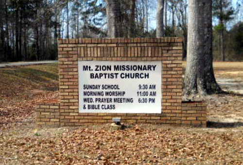
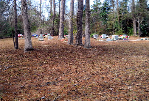
| Description | : | The Mount Zion Missionary Baptist Church Cemetery is unique in all aspects. The church/cemetery sits among a vast expanse of tall pine trees a short distance off the banks of the Alabama River at Claiborne Landing. Small clearings have been cut out of the wilderness and family plots took shape in the clearings. Between the cleared areas will be wide paths on which auto traffic has access. There are deep, passable trenches through or along the margins of the burial areas to allow for good drainage. The picture you see here is just one such... Read More |
frequently asked questions (FAQ):
-
Where is Mount Zion Missionary Baptist Cemetery?
Mount Zion Missionary Baptist Cemetery is located at CR-39 (Grain Elevator Road) Claiborne, Monroe County ,Alabama , 36445USA.
-
Mount Zion Missionary Baptist Cemetery cemetery's updated grave count on graveviews.com?
0 memorials
-
Where are the coordinates of the Mount Zion Missionary Baptist Cemetery?
Latitude: 31.5382200
Longitude: -87.5238800
Nearby Cemetories:
1. Mount Zion Baptist Church Cemetery
Claiborne, Monroe County, USA
Coordinate: 31.5390700, -87.5254300
2. Dellet Family Cemetery
Claiborne, Monroe County, USA
Coordinate: 31.5480213, -87.5146866
3. Claiborne Cemetery
Monroe County, USA
Coordinate: 31.5464001, -87.5124969
4. Claiborne Jewish Cemetery
Claiborne, Monroe County, USA
Coordinate: 31.5254340, -87.5117680
5. Rivers-Scott Cemetery
Claiborne, Monroe County, USA
Coordinate: 31.5507450, -87.5374320
6. McConnico Cemetery
Monroe County, USA
Coordinate: 31.5016994, -87.5108032
7. Crook-Moore Cemetery
Perdue Hill, Monroe County, USA
Coordinate: 31.4971900, -87.5007400
8. Mount Rose Missionary Baptist Church Cemetery
Perdue Hill, Monroe County, USA
Coordinate: 31.5087734, -87.4816564
9. Medlock Cemetery
Perdue Hill, Monroe County, USA
Coordinate: 31.5078640, -87.4751210
10. Mackey Branch Baptist Church Cemetery
Gosport, Clarke County, USA
Coordinate: 31.5815100, -87.5823000
11. Racom Cemetery
Perdue Hill, Monroe County, USA
Coordinate: 31.5101230, -87.4470280
12. Holmes Cemetery
Finchburg, Monroe County, USA
Coordinate: 31.6089320, -87.5036450
13. Crapps Cemetery
Old Salem, Monroe County, USA
Coordinate: 31.5411040, -87.4381380
14. Forwood Cemetery
Gosport, Clarke County, USA
Coordinate: 31.5846220, -87.5904970
15. Williams-English Cemetery
Finchburg, Monroe County, USA
Coordinate: 31.6131880, -87.4987010
16. Hill Family Cemetery
Finchburg, Monroe County, USA
Coordinate: 31.6160340, -87.5176360
17. James Landing Cemetery
Barlow Bend, Clarke County, USA
Coordinate: 31.4925003, -87.5982971
18. Gosport Cemetery
Gosport, Clarke County, USA
Coordinate: 31.5880910, -87.5961080
19. Saint Thomas Church Cemetery
Wainwright, Monroe County, USA
Coordinate: 31.6127110, -87.4849650
20. Lilly Baptist Church Cemetery
Frisco City, Monroe County, USA
Coordinate: 31.4799370, -87.4463290
21. Bright Morning Star Missionary Baptist Cemetery
Frisco City, Monroe County, USA
Coordinate: 31.4793870, -87.4455640
22. Carrymount Baptist Church Cemetery
Monroeville, Monroe County, USA
Coordinate: 31.5816700, -87.4297200
23. Good Hope Baptist Church Cemetery
Franklin, Monroe County, USA
Coordinate: 31.6296330, -87.5127980
24. Old Salem Cemetery
Old Salem, Monroe County, USA
Coordinate: 31.5410260, -87.4094710