
| Memorials | : | 0 |
| Location | : | Colchester Borough, England |
| Coordinate | : | 51.8894590, 0.9039440 |
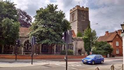
| Description | : | All saints church is opposite Colchester castle . It was shut down in the 1950s and turned into the natural history museums as we know it today . |
frequently asked questions (FAQ):
-
Where is Natural history museum (All Saints church )?
Natural history museum (All Saints church ) is located at 66 High street, Colchester,Essex Colchester Borough ,Essex , Co1 1DNEngland.
-
Natural history museum (All Saints church ) cemetery's updated grave count on graveviews.com?
0 memorials
-
Where are the coordinates of the Natural history museum (All Saints church )?
Latitude: 51.8894590
Longitude: 0.9039440
Nearby Cemetories:
1. St. James the Great Churchyard
Colchester, Colchester Borough, England
Coordinate: 51.8896830, 0.9071770
2. Holy Trinity Church
Colchester, Colchester Borough, England
Coordinate: 51.8888530, 0.8994220
3. St Leonard at the Hythe churchyard
Colchester, Colchester Borough, England
Coordinate: 51.8845600, 0.9231700
4. Colchester Cemetery and Crematorium
Colchester, Colchester Borough, England
Coordinate: 51.8762970, 0.9082550
5. St John's Abbey
Colchester, Colchester Borough, England
Coordinate: 51.9026780, 0.8978050
6. Saint Andrews Churchyard
Colchester, Colchester Borough, England
Coordinate: 51.8866780, 0.9328420
7. St Michael's churchyard
Colchester Borough, England
Coordinate: 51.9107874, 0.8918244
8. St Leonard's Churchyard
Lexden, Colchester Borough, England
Coordinate: 51.8895800, 0.8633820
9. St. John Churchyard
Colchester, Colchester Borough, England
Coordinate: 51.9111950, 0.9285970
10. St Michael's Churchyard
Berechurch, Colchester Borough, England
Coordinate: 51.8600000, 0.8926000
11. All Saints Churchyard
Shrub End, Colchester Borough, England
Coordinate: 51.8722400, 0.8607000
12. West Bergholt Methodist Churchyard
West Bergholt, Colchester Borough, England
Coordinate: 51.9123993, 0.8507000
13. St. Mary the Virgin Church
West Bergholt, Colchester Borough, England
Coordinate: 51.9143650, 0.8501530
14. East Donyland Parish Cemetery
Fingringhoe, Colchester Borough, England
Coordinate: 51.8527840, 0.9378370
15. Old St. Lawrence Churchyard
East Donyland, Colchester Borough, England
Coordinate: 51.8525110, 0.9383250
16. St. Lawrence Churchyard
East Donyland, Colchester Borough, England
Coordinate: 51.8556150, 0.9462830
17. Wivenhoe Cemetery
Wivenhoe, Colchester Borough, England
Coordinate: 51.8616700, 0.9654580
18. St. Mary the Virgin Churchyard
Wivenhoe, Colchester Borough, England
Coordinate: 51.8550794, 0.9594897
19. St. Andrew's Churchyard
Fingringhoe, Colchester Borough, England
Coordinate: 51.8452150, 0.9451480
20. St Andrew Churchyard
Abberton, Colchester Borough, England
Coordinate: 51.8373460, 0.8978390
21. St Albright Churchyard
Stanway, Colchester Borough, England
Coordinate: 51.8830780, 0.8159380
22. St Anne & St Lawrence Churchyard
Elmstead Market, Colchester Borough, England
Coordinate: 51.8943250, 0.9998200
23. St. Michael & All Angels Churchyard
Copford, Colchester Borough, England
Coordinate: 51.8693170, 0.8093620
24. St John the Baptist Churchyard
Layer de la Haye, Colchester Borough, England
Coordinate: 51.8361820, 0.8505660