
| Memorials | : | 0 |
| Location | : | Colchester, Colchester Borough, England |
| Coordinate | : | 51.9026780, 0.8978050 |
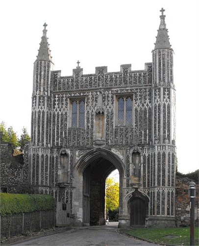
| Description | : | St. John's Abbey (Colchester Abbey) was an Benedictine abbey in Colchester. In 1120 Eudes, steward to William I and Henry II, was buried there, whilst May 1157 Henry II held a trial in the Abbey concerning the right of the pope to over rule him on matters of religion. John Ballard, an archer, captured the archdeacon of Paris during the latter part of the fourteenth century. He deserted from the army before entering Calais and smuggled his prisoner into the Abbey and finally sold him in London for £50. 1523 John Rainsford was accused by Richard Vynes, an ex-servant of the abbot of... Read More |
frequently asked questions (FAQ):
-
Where is St John's Abbey?
St John's Abbey is located at Colchester, Colchester Borough ,Essex ,England.
-
St John's Abbey cemetery's updated grave count on graveviews.com?
0 memorials
-
Where are the coordinates of the St John's Abbey?
Latitude: 51.9026780
Longitude: 0.8978050
Nearby Cemetories:
1. St Michael's churchyard
Colchester Borough, England
Coordinate: 51.9107874, 0.8918244
2. Natural history museum (All Saints church )
Colchester Borough, England
Coordinate: 51.8894590, 0.9039440
3. Holy Trinity Church
Colchester, Colchester Borough, England
Coordinate: 51.8888530, 0.8994220
4. St. James the Great Churchyard
Colchester, Colchester Borough, England
Coordinate: 51.8896830, 0.9071770
5. St. John Churchyard
Colchester, Colchester Borough, England
Coordinate: 51.9111950, 0.9285970
6. St Leonard at the Hythe churchyard
Colchester, Colchester Borough, England
Coordinate: 51.8845600, 0.9231700
7. St Leonard's Churchyard
Lexden, Colchester Borough, England
Coordinate: 51.8895800, 0.8633820
8. Saint Andrews Churchyard
Colchester, Colchester Borough, England
Coordinate: 51.8866780, 0.9328420
9. Colchester Cemetery and Crematorium
Colchester, Colchester Borough, England
Coordinate: 51.8762970, 0.9082550
10. West Bergholt Methodist Churchyard
West Bergholt, Colchester Borough, England
Coordinate: 51.9123993, 0.8507000
11. St. Mary the Virgin Church
West Bergholt, Colchester Borough, England
Coordinate: 51.9143650, 0.8501530
12. All Saints Churchyard
Shrub End, Colchester Borough, England
Coordinate: 51.8722400, 0.8607000
13. St Michael's Churchyard
Berechurch, Colchester Borough, England
Coordinate: 51.8600000, 0.8926000
14. St Albright Churchyard
Stanway, Colchester Borough, England
Coordinate: 51.8830780, 0.8159380
15. All Saints Churchyard
Great Horkesley, Colchester Borough, England
Coordinate: 51.9550190, 0.8672580
16. East Donyland Parish Cemetery
Fingringhoe, Colchester Borough, England
Coordinate: 51.8527840, 0.9378370
17. St. Lawrence Churchyard
East Donyland, Colchester Borough, England
Coordinate: 51.8556150, 0.9462830
18. Old St. Lawrence Churchyard
East Donyland, Colchester Borough, England
Coordinate: 51.8525110, 0.9383250
19. St. Peter and St. Paul's Churchyard
Little Horkesley, Colchester Borough, England
Coordinate: 51.9516000, 0.8517000
20. Wivenhoe Cemetery
Wivenhoe, Colchester Borough, England
Coordinate: 51.8616700, 0.9654580
21. Saint Peters Churchyard
Boxted, Colchester Borough, England
Coordinate: 51.9617380, 0.9072480
22. St. Mary the Virgin Churchyard
Wivenhoe, Colchester Borough, England
Coordinate: 51.8550794, 0.9594897
23. Ardleigh Cemetery
Ardleigh, Tendring District, England
Coordinate: 51.9263900, 0.9893000
24. All Saints Church
Fordham, Colchester Borough, England
Coordinate: 51.9181000, 0.8014340