| Memorials | : | 1 |
| Location | : | Brookings, Curry County, USA |
| Coordinate | : | 42.1331446, -124.0036297 |
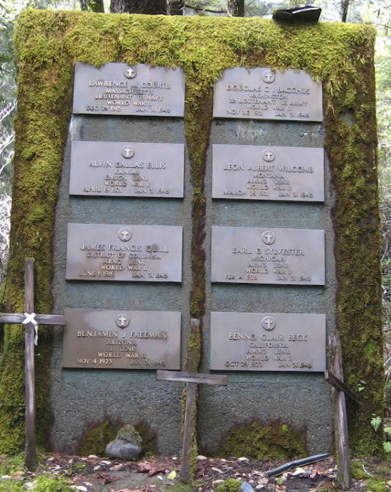
| Description | : | On January 31, 1945, a Navy PBY aircraft on route from San Diego to Seattle crashed due to bad weather. There were no survivors. Due to the extremely rough terrain, the bodies of the crewmen were interred at the crash site. A monument was later added. The site is referred to as the Navy Monument Trail, and is within the Kalmiopsis Wilderness Area. This steep trail follows the old bulldozer path to the wreckage. Parts of the plane can still be seen as well as the monument dedicated to the men that died in... Read More |
frequently asked questions (FAQ):
-
Where is Navy PBY-5A Aircraft Crash Site Memorial?
Navy PBY-5A Aircraft Crash Site Memorial is located at Brookings, Curry County ,Oregon ,USA.
-
Navy PBY-5A Aircraft Crash Site Memorial cemetery's updated grave count on graveviews.com?
1 memorials
-
Where are the coordinates of the Navy PBY-5A Aircraft Crash Site Memorial?
Latitude: 42.1331446
Longitude: -124.0036297
Nearby Cemetories:
1. Hanzicker Grave
Brookings, Curry County, USA
Coordinate: 42.0264310, -124.0097460
2. Costelloe Cemetery
Curry County, USA
Coordinate: 42.0148780, -124.1127480
3. Van Pelt Cemetery
Harbor, Curry County, USA
Coordinate: 42.0480995, -124.2489014
4. Oceanview Cemetery
Harbor, Curry County, USA
Coordinate: 42.0424200, -124.2463400
5. Old Brookings Cemetery
Brookings, Curry County, USA
Coordinate: 42.0619130, -124.2775670
6. Saint Timothys Episcopal Church Memorial Garden
Brookings, Curry County, USA
Coordinate: 42.0570560, -124.2757830
7. Ward Memorial Cemetery
Brookings, Curry County, USA
Coordinate: 42.0681000, -124.2818985
8. How-On-Quet Cemetery
Del Norte County, USA
Coordinate: 41.9553170, -124.2067690
9. Smith River Cemetery
Smith River, Del Norte County, USA
Coordinate: 41.9265640, -124.1557540
10. Cooper Grave
Carpenterville, Curry County, USA
Coordinate: 42.1214670, -124.3382530
11. Yontocket Indian Village Memorial Cemetery
Del Norte County, USA
Coordinate: 41.9071999, -124.1958008
12. Waldo Cemetery
Josephine County, USA
Coordinate: 42.0578720, -123.6538280
13. Laurel Cemetery
Cave Junction, Josephine County, USA
Coordinate: 42.1716995, -123.6346970
14. Madame Gasquet Cemetery
Gasquet, Del Norte County, USA
Coordinate: 41.8497420, -123.9677980
15. St. Patrick's Catholic Cemetery
Takilma, Josephine County, USA
Coordinate: 42.0513360, -123.6359230
16. Takilma Bible Church Cemetery
Takilma, Josephine County, USA
Coordinate: 42.0380000, -123.6292000
17. Spence Family Cemetery
Bridgeview, Josephine County, USA
Coordinate: 42.1253970, -123.6047380
18. French Hill Cemetery
Gasquet, Del Norte County, USA
Coordinate: 41.8252200, -123.9244800
19. Forest Sky Clayberger Burial Site
Crescent City, Del Norte County, USA
Coordinate: 41.8583200, -124.2139690
20. Selma Cemetery
Josephine County, USA
Coordinate: 42.2832985, -123.6153030
21. Camp Lincoln Cemetery
Del Norte County, USA
Coordinate: 41.8196560, -124.1351820
22. Pistol River Cemetery
Pistol River, Curry County, USA
Coordinate: 42.2902985, -124.3985977
23. Deer Creek Cemetery
Selma, Josephine County, USA
Coordinate: 42.2641983, -123.5682983
24. Bear Creek Vineyard Cemetery
Cave Junction, Josephine County, USA
Coordinate: 42.1605730, -123.5341720

