
| Memorials | : | 0 |
| Location | : | Burnt Corn, Conecuh County, USA |
| Coordinate | : | 31.5374760, -87.1349220 |
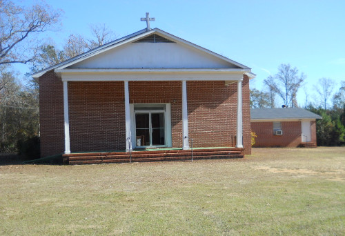
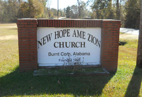
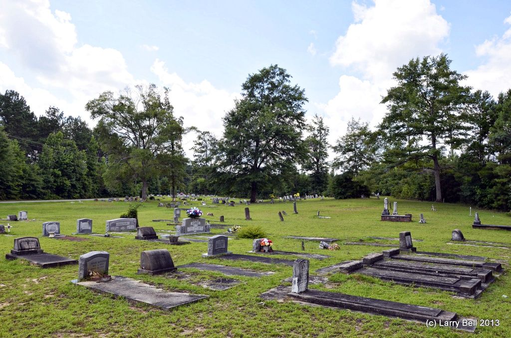
| Description | : | The church building was established in 1968. However, the best records available show the cemetery as having been in existence since 1900 and probably as early as 1850. The New Hope Cemetery is also known as New Hope AME Zion Church and Cemetery. On the Conecuh County map, the location is Section 26, R.9E x T.7N. The historic community of Burnt Corn, Alabama sits on the county line (CR-5) that separates Conecuh and Monroe counties. While a church or business may have its base in Conecuh County, its associated warehouse or cemetery may be on... Read More |
frequently asked questions (FAQ):
-
Where is New Hope AME Church Zion Cemetery?
New Hope AME Church Zion Cemetery is located at County Highway 15 Burnt Corn, Conecuh County ,Alabama ,USA.
-
New Hope AME Church Zion Cemetery cemetery's updated grave count on graveviews.com?
0 memorials
-
Where are the coordinates of the New Hope AME Church Zion Cemetery?
Latitude: 31.5374760
Longitude: -87.1349220
Nearby Cemetories:
1. Lee Cemetery
Conecuh County, USA
Coordinate: 31.5394001, -87.1314011
2. John Green Cemetery
Conecuh County, USA
Coordinate: 31.5417004, -87.1382980
3. Burnt Corn Methodist Cemetery
Burnt Corn, Conecuh County, USA
Coordinate: 31.5503700, -87.1589290
4. Bethany Baptist Church Cemetery
Monroe County, USA
Coordinate: 31.5498700, -87.1597600
5. Ithiel Lee Cemetery
Burnt Corn, Conecuh County, USA
Coordinate: 31.5424800, -87.1064330
6. Breckenridge Cemetery
Burnt Corn, Conecuh County, USA
Coordinate: 31.5568890, -87.1051450
7. Bethany Missionary Baptist Church Cemetery
Monroe County, USA
Coordinate: 31.5391300, -87.1752700
8. Purnell Methodist Church Cemetery
Fairnelson, Conecuh County, USA
Coordinate: 31.5688460, -87.1042010
9. Green Street AME Church Cemetery
Burnt Corn, Conecuh County, USA
Coordinate: 31.5824990, -87.1306990
10. Old Duke Cemetery
Monroe County, USA
Coordinate: 31.5654000, -87.1807330
11. Puryearville Cemetery
Peterman, Monroe County, USA
Coordinate: 31.5452003, -87.1922226
12. Pilgrim Rest AME Zion Church Cemetery
Monroe County, USA
Coordinate: 31.5495110, -87.1933000
13. Fairfield Cemetery
Evergreen, Conecuh County, USA
Coordinate: 31.5307020, -87.0742890
14. Sardis Cemetery
Lyeffion, Conecuh County, USA
Coordinate: 31.5674180, -87.0810870
15. Bethesda Baptist Church Cemetery
Nichburg, Conecuh County, USA
Coordinate: 31.4822580, -87.1340920
16. Martin Cemetery
Conecuh County, USA
Coordinate: 31.5949993, -87.1014023
17. A. J. Ellis Cemetery
Fairnelson, Conecuh County, USA
Coordinate: 31.5514770, -87.0594410
18. Bermuda Community Cemetery
Conecuh County, USA
Coordinate: 31.4864006, -87.1889038
19. Stallworth Cemetery
Nichburg, Conecuh County, USA
Coordinate: 31.4672950, -87.1310930
20. Rankin Cemetery
Monroe County, USA
Coordinate: 31.5763300, -87.2087900
21. Ramah Baptist Church Cemetery
Pine Orchard, Monroe County, USA
Coordinate: 31.6119003, -87.1386032
22. Pleasant Grove Church Cemetery
Bookers Mill, Conecuh County, USA
Coordinate: 31.5275420, -87.0378920
23. Pleasant Grove AME Zion
Evergreen, Conecuh County, USA
Coordinate: 31.5270100, -87.0369500
24. Davis Family Cemetery
Monroe County, USA
Coordinate: 31.5919940, -87.2112360