
| Memorials | : | 0 |
| Location | : | Monroe County, USA |
| Coordinate | : | 31.5919940, -87.2112360 |
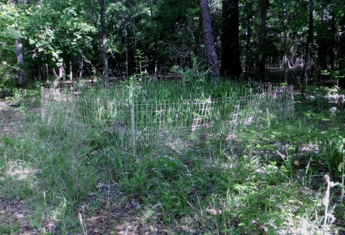
| Description | : | This small family cemetery is not easily found. It lies in deep woods on a red clay road, clearly visible however from the roadway. There is a small clearing about 20 yards deep and the 10x10 fenced area is beneath a large white oak tree. The fenced area is overgrown with ferns and wild gladiolus. There is no evidence that a homestead once stood here, but might be assumed that one did exist until at least 1911. Make no mistake, these woods are primitive but the forest floor is clean of tangled underbrush. From Burt Corn, Alabama travel... Read More |
frequently asked questions (FAQ):
-
Where is Davis Family Cemetery?
Davis Family Cemetery is located at Nettles Mill Road Monroe County ,Alabama , 36471USA.
-
Davis Family Cemetery cemetery's updated grave count on graveviews.com?
0 memorials
-
Where are the coordinates of the Davis Family Cemetery?
Latitude: 31.5919940
Longitude: -87.2112360
Nearby Cemetories:
1. Rankin Cemetery
Monroe County, USA
Coordinate: 31.5763300, -87.2087900
2. Poindexter Cemetery
Peterman, Monroe County, USA
Coordinate: 31.5738500, -87.2314210
3. Rumbley Cemetery
Monroeville, Monroe County, USA
Coordinate: 31.5718994, -87.2463989
4. Old Duke Cemetery
Monroe County, USA
Coordinate: 31.5654000, -87.1807330
5. Pilgrim Rest AME Zion Church Cemetery
Monroe County, USA
Coordinate: 31.5495110, -87.1933000
6. Puryearville Cemetery
Peterman, Monroe County, USA
Coordinate: 31.5452003, -87.1922226
7. Liberty Church Cemetery
Tunnel Springs, Monroe County, USA
Coordinate: 31.6360050, -87.2440810
8. Antioch Baptist Church Cemetery
Tunnel Springs, Monroe County, USA
Coordinate: 31.6411430, -87.1867490
9. Bethany Baptist Church Cemetery
Monroe County, USA
Coordinate: 31.5498700, -87.1597600
10. Philadelphia Baptist Church Cemetery
Tunnel Springs, Monroe County, USA
Coordinate: 31.6480060, -87.2394500
11. Burnt Corn Methodist Cemetery
Burnt Corn, Conecuh County, USA
Coordinate: 31.5503700, -87.1589290
12. Bethany Missionary Baptist Church Cemetery
Monroe County, USA
Coordinate: 31.5391300, -87.1752700
13. Mars Hill Baptist Church Cemetery
Peterman, Monroe County, USA
Coordinate: 31.5942320, -87.2849240
14. Amity Cemetery
Tunnel Springs, Monroe County, USA
Coordinate: 31.6394660, -87.2619360
15. Ramah Baptist Church Cemetery
Pine Orchard, Monroe County, USA
Coordinate: 31.6119003, -87.1386032
16. Old Limestone Baptist Cemetery
Monroeton, Monroe County, USA
Coordinate: 31.5348330, -87.2478330
17. Fountain Cemetery
Tunnel Springs, Monroe County, USA
Coordinate: 31.6588600, -87.2219260
18. Green Street AME Church Cemetery
Burnt Corn, Conecuh County, USA
Coordinate: 31.5824990, -87.1306990
19. Daniel Baptist Church Cemetery
Monroeville, Monroe County, USA
Coordinate: 31.5347760, -87.2588660
20. Mount Olive Baptist Church Cemetery
Monroe County, USA
Coordinate: 31.6145950, -87.2941930
21. Foster Cemetery
Monroeton, Monroe County, USA
Coordinate: 31.5257670, -87.2540670
22. Cunningham Cemetery
Tunnel Springs, Monroe County, USA
Coordinate: 31.6575090, -87.2601990
23. John Green Cemetery
Conecuh County, USA
Coordinate: 31.5417004, -87.1382980
24. Pine Orchard Cemetery
Conecuh County, USA
Coordinate: 31.6408005, -87.1355972