
| Memorials | : | 0 |
| Location | : | Amsterdam, Amsterdam Municipality, Netherlands |
| Coordinate | : | 52.3681070, 4.8922740 |
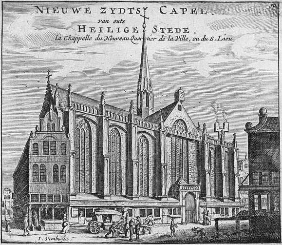
| Description | : | The site where the Nieuwezijds Kapel stood is located in Amsterdam at 78-80 Rokin. The first church at this location, the Heilige Stede (Holy Site), was built by Catholics in 1347 to commemorate a miracle said to have occurred here in 1345. The first church burned down in 1452 but was rebuilt. In 1578 the church was taken over by the Dutch Reformed Church and renamed the Nieuwezijds Kapel. Between 1908 and 1912, the church was “deconstructed” and replaced with a new church, shops, and houses. The Dutch Reformed Church stopped using the site... Read More |
frequently asked questions (FAQ):
-
Where is Nieuwezijds Kapel?
Nieuwezijds Kapel is located at Amsterdam, Amsterdam Municipality ,Noord-Holland ,Netherlands.
-
Nieuwezijds Kapel cemetery's updated grave count on graveviews.com?
0 memorials
-
Where are the coordinates of the Nieuwezijds Kapel?
Latitude: 52.3681070
Longitude: 4.8922740
Nearby Cemetories:
1. English Reformed Church at the Begijnhof
Amsterdam, Amsterdam Municipality, Netherlands
Coordinate: 52.3693210, 4.8900540
2. Zuiderkerk
Amsterdam, Amsterdam Municipality, Netherlands
Coordinate: 52.3702900, 4.8998490
3. Nieuwe Kerk
Amsterdam, Amsterdam Municipality, Netherlands
Coordinate: 52.3739180, 4.8917450
4. Oude Kerk
Amsterdam, Amsterdam Municipality, Netherlands
Coordinate: 52.3743350, 4.8979600
5. Westerkerk
Amsterdam, Amsterdam Municipality, Netherlands
Coordinate: 52.3745420, 4.8838520
6. Amsterdam Oude Oosterbegraafplaats (Defunct)
Amsterdam, Amsterdam Municipality, Netherlands
Coordinate: 52.3621570, 4.9209740
7. Amsterdam Begraafplaats Vredenhof
Amsterdam, Amsterdam Municipality, Netherlands
Coordinate: 52.3848600, 4.8621200
8. Sint-Barbara Katholieke Begraafplaats
Amsterdam, Amsterdam Municipality, Netherlands
Coordinate: 52.3915300, 4.8631700
9. Amsterdam R.K. Begraafplaats Buitenveldert
Buitenveldert, Amsterdam Municipality, Netherlands
Coordinate: 52.3406200, 4.8612100
10. Amsterdam Begraafplaats Zorgvlied
Amsterdam, Amsterdam Municipality, Netherlands
Coordinate: 52.3354500, 4.9050700
11. Amsterdam Begraafplaats 't Huis te Vraag
Amsterdam, Amsterdam Municipality, Netherlands
Coordinate: 52.3471200, 4.8488400
12. Joodse Begraafplaats Zeeburg
Amsterdam, Amsterdam Municipality, Netherlands
Coordinate: 52.3613840, 4.9491050
13. De Nieuwe Ooster
Amsterdam, Amsterdam Municipality, Netherlands
Coordinate: 52.3464400, 4.9388500
14. Buiksloot Kerkhof
Amsterdam, Amsterdam Municipality, Netherlands
Coordinate: 52.4017192, 4.9165272
15. Kerkhof Nieuwendam Nieuwendam
Nieuwendam, Amsterdam Municipality, Netherlands
Coordinate: 52.3919138, 4.9409809
16. De Nieuwe Noorder
Amsterdam, Amsterdam Municipality, Netherlands
Coordinate: 52.4065600, 4.9266200
17. Old Diemen Cemetery
Diemen, Diemen Municipality, Netherlands
Coordinate: 52.3490280, 4.9728890
18. Nederlands-Israëlitische Begraafplaats
Diemen, Diemen Municipality, Netherlands
Coordinate: 52.3446530, 4.9711020
19. Begraafplaats Rustoord
Diemen, Diemen Municipality, Netherlands
Coordinate: 52.3364200, 4.9652900
20. Durgerdam Kerkhof
Durgerdam, Amsterdam Municipality, Netherlands
Coordinate: 52.3783100, 4.9880600
21. Zaandam Crematorium and General Cemetery
Zaandam, Zaanstad Municipality, Netherlands
Coordinate: 52.4252200, 4.8398700
22. Ransdorp Algemene Begraafplaats
Ransdorp, Amsterdam Municipality, Netherlands
Coordinate: 52.3929000, 4.9938600
23. Amsterdam Westgaarde Herdenkingspark
Amsterdam, Amsterdam Municipality, Netherlands
Coordinate: 52.3596600, 4.7801600
24. Beth Haim Portugees-Israëlietische Begraafplaats
Ouderkerk aan de Amstel, Ouder-Amstel Municipality, Netherlands
Coordinate: 52.2952780, 4.9041670