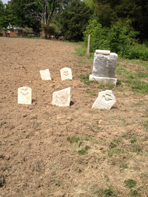
| Memorials | : | 0 |
| Location | : | Eudora, DeSoto County, USA |
| Coordinate | : | 34.8356300, -90.1485860 |
| Description | : | Located in R9W, T3S, Sec. 10. It was originally part of the Eudora Baptist Church cemetery across the highway, and is located on the north side of Highway 301 northeast of Eudora Cross Roads. The east side was abandoned when Highway 301 was built. Surveyed in the 1980s. |
frequently asked questions (FAQ):
-
Where is Old Eudora Baptist Cemetery?
Old Eudora Baptist Cemetery is located at 1714 MS-301 Eudora, DeSoto County ,Mississippi , 38632USA.
-
Old Eudora Baptist Cemetery cemetery's updated grave count on graveviews.com?
0 memorials
-
Where are the coordinates of the Old Eudora Baptist Cemetery?
Latitude: 34.8356300
Longitude: -90.1485860
Nearby Cemetories:
1. Eudora Baptist Cemetery
Eudora, DeSoto County, USA
Coordinate: 34.8372500, -90.1494100
2. Second Eudora M. B. Church Cemetery
Lake Cormorant, DeSoto County, USA
Coordinate: 34.8300900, -90.1400310
3. Goodrum Memorial Cemetery
Eudora, DeSoto County, USA
Coordinate: 34.8307290, -90.1673980
4. Bullard's Chapel CME Cemetery
Eudora, DeSoto County, USA
Coordinate: 34.8596720, -90.1318260
5. Trinity Baptist Cemetery
Eudora, DeSoto County, USA
Coordinate: 34.8072810, -90.1789750
6. Pleasant Grove CME Church Cemetery
Eudora, DeSoto County, USA
Coordinate: 34.7947270, -90.1475890
7. Koko Reef Church of Christ Cemetery
Hernando, DeSoto County, USA
Coordinate: 34.7811260, -90.1857990
8. Oak Grove Church Cemetery
Hernando, DeSoto County, USA
Coordinate: 34.8092190, -90.0782130
9. Liberty Hill Church Cemetery
Lake Cormorant, DeSoto County, USA
Coordinate: 34.9007690, -90.1500420
10. Union Hill Cemetery
Eudora, DeSoto County, USA
Coordinate: 34.7710470, -90.1640790
11. Rising Sun Road Cemetery
Hernando, DeSoto County, USA
Coordinate: 34.8231110, -90.0694400
12. Dean Hill Baptist Church Cemetery
Lake Cormorant, DeSoto County, USA
Coordinate: 34.8755930, -90.0827820
13. Pleasant Hill MB Church Cemetery
Pleasant Hill, DeSoto County, USA
Coordinate: 34.7863640, -90.0852230
14. Brown Family Cemetery
Hernando, DeSoto County, USA
Coordinate: 34.7933040, -90.0769560
15. Dean Family Cemetery
Nesbit, DeSoto County, USA
Coordinate: 34.8861650, -90.0839050
16. Glenns Chapel Church Cemetery
Lake Cormorant, DeSoto County, USA
Coordinate: 34.9040230, -90.1131410
17. Oliver Family Cemetery
Hernando, DeSoto County, USA
Coordinate: 34.8280460, -90.0427010
18. Huddleston Family Cemetery
Hernando, DeSoto County, USA
Coordinate: 34.8535000, -90.0426000
19. Bethlehem CME Church Cemetery
Lake Cormorant, DeSoto County, USA
Coordinate: 34.9195120, -90.2029670
20. Ella Green Baptist Church Cemetery
Coldwater, Tate County, USA
Coordinate: 34.7416920, -90.1293610
21. Mount Zion Church Cemetery
Walls, DeSoto County, USA
Coordinate: 34.9330240, -90.1549360
22. Channel Hill MB Church Cemetery
Walls, DeSoto County, USA
Coordinate: 34.9335200, -90.1175500
23. Saint Mary MB Church Cemetery
Hernando, DeSoto County, USA
Coordinate: 34.8672700, -90.0287500
24. Rising Sun MB Church Cemetery
Lake Cormorant, DeSoto County, USA
Coordinate: 34.8619600, -90.2751200

