
| Memorials | : | 0 |
| Location | : | Hernando, DeSoto County, USA |
| Coordinate | : | 34.8280460, -90.0427010 |
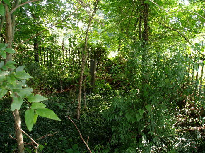
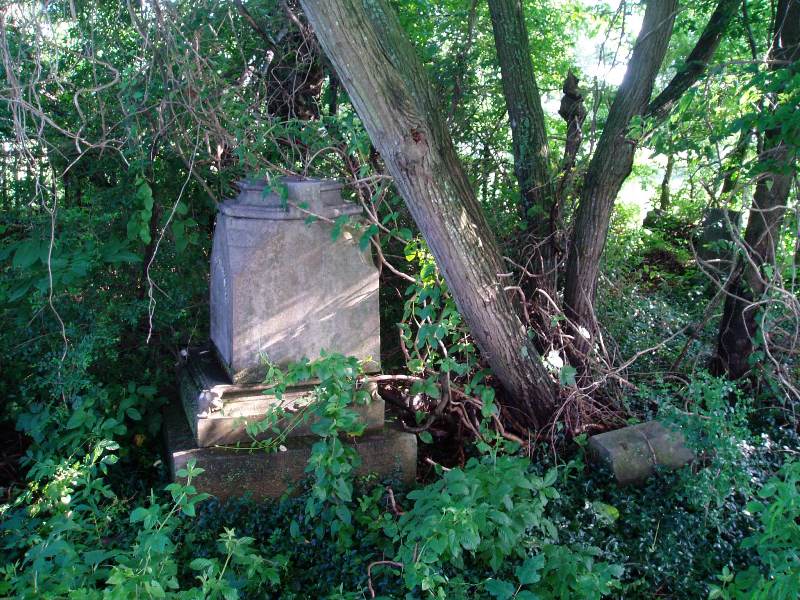
| Description | : | The Oliver Family Cemetery is located on the old Simeon Oliver plantation (now the Jones Farm) on highway 304, about 2.9 miles west of the courthouse in Hernando, in the NE corner of Section 16, Township 3 S, Range 8 W. From the courthouse, travel west on Hwy. 304, about 2.9 miles, going past an old cotton gin and a John Deere dealership, to the Jones' brick house on the south (left) side on a small hill. With permission, this 'deeded' cemetery is about 1000' south of the house in their pasture. It is heavily overgrown and very... Read More |
frequently asked questions (FAQ):
-
Where is Oliver Family Cemetery?
Oliver Family Cemetery is located at 3067 MS-304/W Commerce St Hernando, DeSoto County ,Mississippi ,USA.
-
Oliver Family Cemetery cemetery's updated grave count on graveviews.com?
0 memorials
-
Where are the coordinates of the Oliver Family Cemetery?
Latitude: 34.8280460
Longitude: -90.0427010
Nearby Cemetories:
1. Rising Sun Road Cemetery
Hernando, DeSoto County, USA
Coordinate: 34.8231110, -90.0694400
2. Huddleston Family Cemetery
Hernando, DeSoto County, USA
Coordinate: 34.8535000, -90.0426000
3. Oak Grove Church Cemetery
Hernando, DeSoto County, USA
Coordinate: 34.8092190, -90.0782130
4. Springhill Cemetery
Hernando, DeSoto County, USA
Coordinate: 34.8165870, -90.0020220
5. Vance Family Cemetery
Hernando, DeSoto County, USA
Coordinate: 34.8285220, -89.9993010
6. Saint Mary MB Church Cemetery
Hernando, DeSoto County, USA
Coordinate: 34.8672700, -90.0287500
7. Hernando Memorial Park
Hernando, DeSoto County, USA
Coordinate: 34.8175080, -89.9909620
8. Robertson Family Cemetery
Hernando, DeSoto County, USA
Coordinate: 34.7850740, -90.0318010
9. Brown Family Cemetery
Hernando, DeSoto County, USA
Coordinate: 34.7933040, -90.0769560
10. Pleasant Hill MB Church Cemetery
Pleasant Hill, DeSoto County, USA
Coordinate: 34.7863640, -90.0852230
11. Dean Hill Baptist Church Cemetery
Lake Cormorant, DeSoto County, USA
Coordinate: 34.8755930, -90.0827820
12. Wheeler Cemetery
Hernando, DeSoto County, USA
Coordinate: 34.7984270, -89.9801780
13. Bethlehem Baptist Church Cemetery
Hernando, DeSoto County, USA
Coordinate: 34.8747700, -89.9929200
14. Bethlehem Cemetery
Nesbit, DeSoto County, USA
Coordinate: 34.8742630, -89.9898520
15. Zion Hill Missionary Baptist Church Cemetery
Robinson Gin, DeSoto County, USA
Coordinate: 34.7655260, -90.0242000
16. Nesbit Cemetery
Hernando, DeSoto County, USA
Coordinate: 34.8872010, -90.0108340
17. Robinson Family Cemetery
Nesbit, DeSoto County, USA
Coordinate: 34.8876620, -90.0070020
18. Dean Family Cemetery
Nesbit, DeSoto County, USA
Coordinate: 34.8861650, -90.0839050
19. Banks Family Cemetery
Hernando, DeSoto County, USA
Coordinate: 34.8487500, -89.9628060
20. Farley Cemetery
DeSoto County, USA
Coordinate: 34.7841988, -89.9721985
21. Forrest Family Cemetery
Hernando, DeSoto County, USA
Coordinate: 34.8170000, -89.9530000
22. New Bethany Cemetery
Hernando, DeSoto County, USA
Coordinate: 34.8531000, -89.9547000
23. Oak Grove M.B. Church Cemetery
Nesbit, DeSoto County, USA
Coordinate: 34.8974750, -89.9982130
24. Halliburton Baptist Church Cemetery
Nesbit, DeSoto County, USA
Coordinate: 34.9049750, -90.0237630