
| Memorials | : | 1 |
| Location | : | Mangum, Richmond County, USA |
| Coordinate | : | 35.1155270, -79.9863650 |
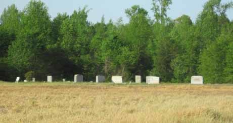
| Description | : | Smith Ferry Road Mangum Steeles Township Drive down the dirt road going south, toward the Pee Dee River. The cemetery is located in a field on the right, well maintained, surrounded by farm crops. Not far from the Pee Dee River. People are still being buried here. |
frequently asked questions (FAQ):
-
Where is Old Hebron Methodist Church Cemetery?
Old Hebron Methodist Church Cemetery is located at Smith Ferry Rd. Mangum, Richmond County ,North Carolina ,USA.
-
Old Hebron Methodist Church Cemetery cemetery's updated grave count on graveviews.com?
0 memorials
-
Where are the coordinates of the Old Hebron Methodist Church Cemetery?
Latitude: 35.1155270
Longitude: -79.9863650
Nearby Cemetories:
1. Pemberton Cemetery
Richmond County, USA
Coordinate: 35.1020570, -79.9932800
2. Oliver Grove Missionary Baptist Church Cemetery
Mount Gilead, Montgomery County, USA
Coordinate: 35.1303220, -79.9854950
3. Oliver Grove Baptist Church Cemetery
Mangum, Richmond County, USA
Coordinate: 35.1305440, -79.9857090
4. Mount Airy AME Zion Church Cemetery
Mangum, Richmond County, USA
Coordinate: 35.1319500, -79.9971600
5. Legrand Cemetery
Richmond County, USA
Coordinate: 35.1156006, -80.0227966
6. Machine House Cemetery
Richmond County, USA
Coordinate: 35.0992012, -80.0246964
7. Chestnut AME Zion Church Cemetery
Richmond County, USA
Coordinate: 35.1269770, -80.0311010
8. Hamer Creek Baptist Church Cemetery
Mount Gilead, Montgomery County, USA
Coordinate: 35.1593370, -80.0138730
9. Snow Hill AME Zion Church Cemetery
Mangum, Richmond County, USA
Coordinate: 35.1328380, -79.9269970
10. George Stanback Cemetery
Ellerbe, Richmond County, USA
Coordinate: 35.1233660, -79.9218680
11. Saint Stephen AME Church Cemetery
Mount Gilead, Montgomery County, USA
Coordinate: 35.1479550, -80.0447190
12. Melton Grove United Methodist Church Cemetery
Mount Gilead, Montgomery County, USA
Coordinate: 35.1698160, -80.0134250
13. James McRae Cemetery
Wadesboro, Anson County, USA
Coordinate: 35.0569800, -80.0120540
14. Thomasville Missionary Baptist Church Cemetery
Mount Gilead, Montgomery County, USA
Coordinate: 35.1718180, -80.0203510
15. Frazier Family Cemetery
Mount Gilead, Montgomery County, USA
Coordinate: 35.1786400, -79.9854870
16. Ledbetter Cemetery
Richmond County, USA
Coordinate: 35.1506004, -79.9214020
17. Galloway Cemetery
Mount Gilead, Montgomery County, USA
Coordinate: 35.1779210, -80.0155840
18. Colson-Kirby Cemetery
Lilesville, Anson County, USA
Coordinate: 35.0393350, -79.9939330
19. Pleasant Grove Church Cemetery
Mount Gilead, Montgomery County, USA
Coordinate: 35.1967010, -79.9944000
20. Brookshire-Powell Family Cemetery
Covington, Richmond County, USA
Coordinate: 35.1353960, -79.8855610
21. Pleasant Grove Baptist Church Cemetery
Wadesboro, Anson County, USA
Coordinate: 35.0405210, -80.0374390
22. Ingram Chapel Cemetery
Mount Gilead, Montgomery County, USA
Coordinate: 35.1971130, -79.9533320
23. Allen Cemetery
Wadesboro, Anson County, USA
Coordinate: 35.0319550, -80.0157290
24. Savannah Methodist Church Cemetery
Lilesville, Anson County, USA
Coordinate: 35.0388100, -79.9331700