
| Memorials | : | 0 |
| Location | : | Pond Creek, Grant County, USA |
| Coordinate | : | 36.7086920, -97.7909950 |
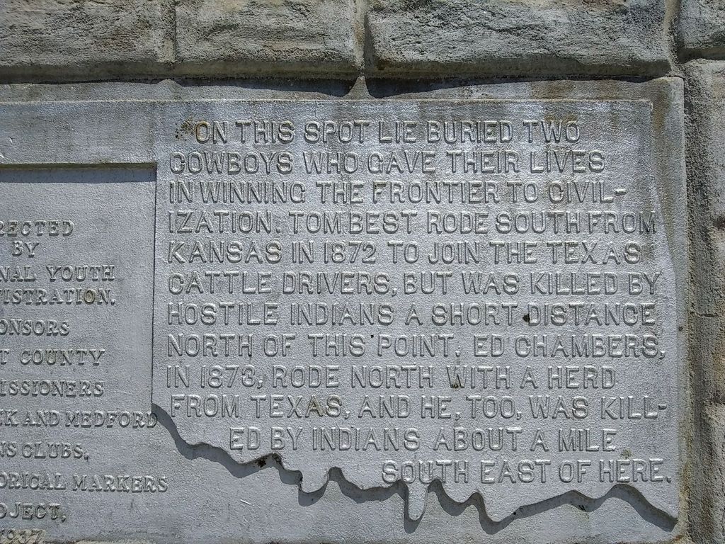
| Description | : | On EO210 Road, about 3000 ft. east of Highway 81 (about 350 ft. past the railroad tracks), there is a tall, limestone marker about 200 ft. into the field on the south side of the road. This is the marker for the Cowboy Burials. About 200 ft. to the north of the road, and a little to the east, is another, similar marker demarcating the location of the Sewell Stockade, later known as the Pond Creek Ranch-house. This site, and its pair of markers, is mainly of note for its association with the Chisholm Cattle Trail. |
frequently asked questions (FAQ):
-
Where is Old Pond Creek Ranch Cowboy Burials?
Old Pond Creek Ranch Cowboy Burials is located at EO210 RD Pond Creek, Grant County ,Oklahoma , 73766USA.
-
Old Pond Creek Ranch Cowboy Burials cemetery's updated grave count on graveviews.com?
0 memorials
-
Where are the coordinates of the Old Pond Creek Ranch Cowboy Burials?
Latitude: 36.7086920
Longitude: -97.7909950
Nearby Cemetories:
1. Pond Creek Cemetery
Pond Creek, Grant County, USA
Coordinate: 36.6521988, -97.7936020
2. Smith Cemetery
Jefferson, Grant County, USA
Coordinate: 36.7088800, -97.7139000
3. Liberty Cemetery
Grant County, USA
Coordinate: 36.7235985, -97.7149963
4. Klondike Cemetery
Grant County, USA
Coordinate: 36.7592010, -97.8566971
5. Fairview Cemetery
Grant County, USA
Coordinate: 36.7813988, -97.8139038
6. Greenwood Cemetery
Pond Creek, Grant County, USA
Coordinate: 36.6366600, -97.7054000
7. Valley Center Cemetery
Pond Creek, Grant County, USA
Coordinate: 36.6081009, -97.8281021
8. Pleasant Hill Cemetery
Medford, Grant County, USA
Coordinate: 36.7742900, -97.9130000
9. Rosemound Cemetery
Medford, Grant County, USA
Coordinate: 36.8044014, -97.7039032
10. Mount Zion Cemetery
Nash, Grant County, USA
Coordinate: 36.6594009, -97.9285965
11. Coldwater Cemetery
Grant County, USA
Coordinate: 36.6956900, -97.9571500
12. Saint Anthony Cemetery
Clyde, Grant County, USA
Coordinate: 36.8478012, -97.8193970
13. Medford Mennonite Cemetery
Medford, Grant County, USA
Coordinate: 36.8403000, -97.6968000
14. Mount Pleasant Cemetery
Salt Fork, Grant County, USA
Coordinate: 36.6217003, -97.6333008
15. Saint Mary Calvary Cemetery
Medford, Grant County, USA
Coordinate: 36.8471985, -97.7061005
16. Kremlin Cemetery
Kremlin, Garfield County, USA
Coordinate: 36.5494003, -97.8131027
17. White Cemetery
Hunter, Garfield County, USA
Coordinate: 36.5788994, -97.6660995
18. Lamont Cemetery
Lamont, Grant County, USA
Coordinate: 36.6967010, -97.5792007
19. Turek Cemetery
Medford, Grant County, USA
Coordinate: 36.8544006, -97.6513977
20. Hawley Cemetery
Hawley, Grant County, USA
Coordinate: 36.7667007, -98.0231018
21. Wakita Cemetery
Wakita, Grant County, USA
Coordinate: 36.8694000, -97.9302979
22. Richland Cemetery
Grant County, USA
Coordinate: 36.8974991, -97.7055969
23. Hillsdale Cemetery
Hillsdale, Garfield County, USA
Coordinate: 36.5652800, -97.9701700
24. Czecko Slovak Cemetery
Grant County, USA
Coordinate: 36.8692017, -97.6288986