
| Memorials | : | 0 |
| Location | : | Oostelbeers, Oirschot Municipality, Netherlands |
| Coordinate | : | 51.4711900, 5.2704500 |
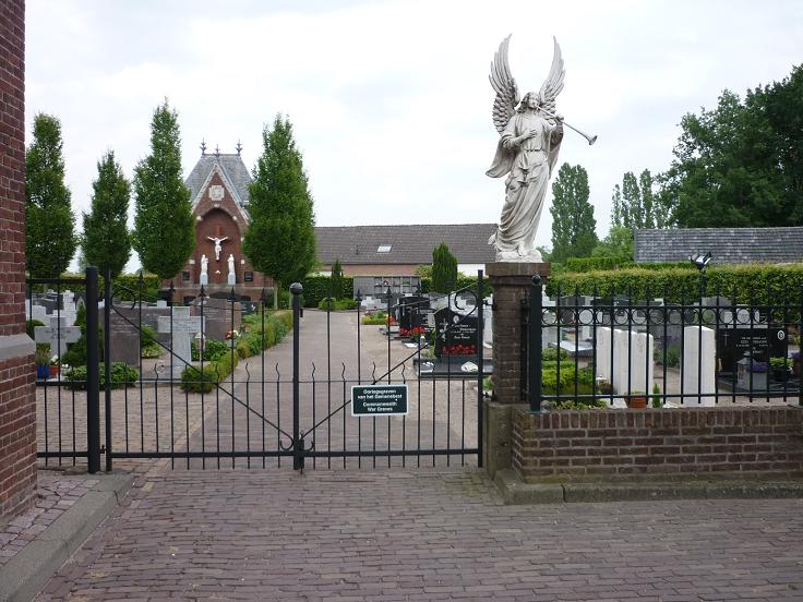
| Description | : | Oostelbeers is a small village 13 kilometres north-west of Eindhoven. The churchyard is in the centre of the village. |
frequently asked questions (FAQ):
-
Where is Oostelbeers Roman Catholic Churchyard?
Oostelbeers Roman Catholic Churchyard is located at Oostelbeers, Oirschot Municipality ,Noord-Brabant ,Netherlands.
-
Oostelbeers Roman Catholic Churchyard cemetery's updated grave count on graveviews.com?
0 memorials
-
Where are the coordinates of the Oostelbeers Roman Catholic Churchyard?
Latitude: 51.4711900
Longitude: 5.2704500
Nearby Cemetories:
1. Oude Joodse Begraafplaats
Oirschot Municipality, Netherlands
Coordinate: 51.4956170, 5.3138480
2. Diessen Roman Catholic Churchyard
Diessen, Hilvarenbeek Municipality, Netherlands
Coordinate: 51.4750600, 5.1751700
3. Biest-Houtakker Roman Catholic Churchyard
Biest-Houtakker, Hilvarenbeek Municipality, Netherlands
Coordinate: 51.5081400, 5.1604400
4. Hilvarenbeek Protestant Cemetery
Hilvarenbeek, Hilvarenbeek Municipality, Netherlands
Coordinate: 51.4703400, 5.1414300
5. Hilvarenbeek Rooms-Katholieke Begraafplaats
Hilvarenbeek, Hilvarenbeek Municipality, Netherlands
Coordinate: 51.4886600, 5.1369300
6. Veldhoven Begraafplaats Hoge Boght
Veldhoven, Veldhoven Municipality, Netherlands
Coordinate: 51.4116700, 5.3683800
7. Moergestel Rooms Katholieke Begraafplaats
Moergestel, Oisterwijk Municipality, Netherlands
Coordinate: 51.5436600, 5.1858400
8. Sint-Severinuskerkhof
Hapert, Bladel Municipality, Netherlands
Coordinate: 51.3706200, 5.2520700
9. Joodse Begraafplaats Grote Beek
Eindhoven Municipality, Netherlands
Coordinate: 51.4693300, 5.4443700
10. Joodse Begraafplaats
Oisterwijk, Oisterwijk Municipality, Netherlands
Coordinate: 51.5659700, 5.1857700
11. Joodse Begraafplaats
Eindhoven, Eindhoven Municipality, Netherlands
Coordinate: 51.4507900, 5.4577600
12. Begraafplaats Sint Trudo
Eindhoven Municipality, Netherlands
Coordinate: 51.4408198, 5.4546763
13. St. Peter Roman Catholic Churchyard
Oisterwijk, Oisterwijk Municipality, Netherlands
Coordinate: 51.5780500, 5.1841500
14. Oisterwijk Protestant Churchyard
Oisterwijk, Oisterwijk Municipality, Netherlands
Coordinate: 51.5796900, 5.1874600
15. Begraafplaats Sint Paulus
Eindhoven, Eindhoven Municipality, Netherlands
Coordinate: 51.4551800, 5.4625000
16. Boxtel Roman Catholic Church Cemetery
Boxtel, Boxtel Municipality, Netherlands
Coordinate: 51.5896100, 5.3164800
17. Sint-Severinuskerkhof
Eindhoven, Eindhoven Municipality, Netherlands
Coordinate: 51.4176300, 5.4495100
18. Woensel General Cemetery
Woensel, Eindhoven Municipality, Netherlands
Coordinate: 51.4553100, 5.4822500
19. Tilburg Sint-Joseph Roman Catholic Cemetery
Tilburg, Tilburg Municipality, Netherlands
Coordinate: 51.5560700, 5.1042200
20. Eindhoven Sint-Catharina Cemetery
Eindhoven, Eindhoven Municipality, Netherlands
Coordinate: 51.4337600, 5.4773100
21. Tilburg Broekhoven Catholic Cemetery
Tilburg, Tilburg Municipality, Netherlands
Coordinate: 51.5452770, 5.0883180
22. Goirle Sint-Jan Roman Catholic Cemetery
Goirle, Goirle Municipality, Netherlands
Coordinate: 51.5191200, 5.0652200
23. Goirle Maria Boodschap Roman Catholic Cemetery
Goirle, Goirle Municipality, Netherlands
Coordinate: 51.5259300, 5.0632200
24. Berkel Roman Catholic Cemetery
Berkel-Enschot, Tilburg Municipality, Netherlands
Coordinate: 51.5889200, 5.1430100