
| Memorials | : | 0 |
| Location | : | Gentrys Mill, Adair County, USA |
| Coordinate | : | 37.0693170, -85.1608500 |
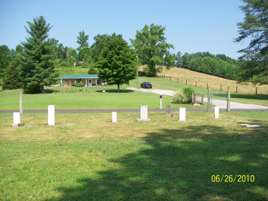
| Description | : | The Perryman Cemetery was located on the left side of Rutledge Rd. in Adair County, KY at 37.06932, -85.16085. As of July 30, 2010, all remaining stones at the cemetery have been reinterred, although many individuals are still buried there in unmarked graves. Several gravestones were destroyed by a bulldozer, probably in the 1960s or 1970s. A few other gravestones were destroyed by vandals following that. The fence has been removed from the property and it will no longer be maintained as a cemetery by the previous caretakers. All of the vandalized stones were pushed over the... Read More |
frequently asked questions (FAQ):
-
Where is Perryman Cemetery?
Perryman Cemetery is located at Rutledge Road Gentrys Mill, Adair County ,Kentucky ,USA.
-
Perryman Cemetery cemetery's updated grave count on graveviews.com?
0 memorials
-
Where are the coordinates of the Perryman Cemetery?
Latitude: 37.0693170
Longitude: -85.1608500
Nearby Cemetories:
1. Conover Cemetery
Gentrys Mill, Adair County, USA
Coordinate: 37.0793020, -85.1630950
2. Womack Cemetery
Gentrys Mill, Adair County, USA
Coordinate: 37.0634613, -85.1489029
3. Freedom Cemetery
Adair County, USA
Coordinate: 37.0723680, -85.1820340
4. Gentry Cemetery
Gentrys Mill, Adair County, USA
Coordinate: 37.0844193, -85.1502991
5. Bailey Cemetery
Gentrys Mill, Adair County, USA
Coordinate: 37.0718498, -85.1826935
6. Acree Cemetery
Columbia, Adair County, USA
Coordinate: 37.0495600, -85.1675000
7. Conover Cemetery
Adair County, USA
Coordinate: 37.0561100, -85.1893910
8. Haynes Cemetery
Montpelier, Adair County, USA
Coordinate: 37.0383900, -85.1682500
9. Taylor Cemetery
Columbia, Adair County, USA
Coordinate: 37.0634210, -85.2031370
10. Franklin Bryant Cemetery
Columbia, Adair County, USA
Coordinate: 37.0706110, -85.2089720
11. Murrell Cemetery
Craycraft, Adair County, USA
Coordinate: 37.0942700, -85.2008000
12. Cravens Cemetery
Craycraft, Adair County, USA
Coordinate: 37.1028404, -85.1978912
13. Combest Family Cemetery
Ozark, Adair County, USA
Coordinate: 37.0694200, -85.2173670
14. Sparks Cemetery
Ozark, Adair County, USA
Coordinate: 37.0485900, -85.2133000
15. Grider Cemetery
Columbia, Adair County, USA
Coordinate: 37.1093990, -85.1938390
16. Leach Cemetery
Montpelier, Adair County, USA
Coordinate: 37.0254810, -85.1880910
17. Old Bethel Cemetery
Montpelier, Adair County, USA
Coordinate: 37.0252160, -85.1879190
18. Pleasant Grove Cemetery
Montpelier, Adair County, USA
Coordinate: 37.0250320, -85.1884710
19. Grider Cemetery
New Concord, Adair County, USA
Coordinate: 37.0941670, -85.2176170
20. Pleasant Hill Cemetery
Montpelier, Adair County, USA
Coordinate: 37.0312930, -85.2075790
21. Shiloh Christian Church Cemetery
Ozark, Adair County, USA
Coordinate: 37.0766830, -85.2283170
22. Concord Cemetery
New Concord, Adair County, USA
Coordinate: 37.0973700, -85.2221100
23. Reeves Family Cemetery
Ozark, Adair County, USA
Coordinate: 37.0689700, -85.2317100
24. Lander Bryant Cemetery
Ozark, Adair County, USA
Coordinate: 37.0819283, -85.2305679