
| Memorials | : | 0 |
| Location | : | Ponsonby, Copeland Borough, England |
| Coordinate | : | 54.4367970, -3.4782480 |
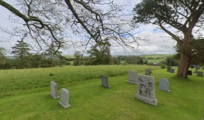
| Description | : | Ponsonby Parish Church stands on a hillside under the shadow of Sellafield Nuclear Base. The church had connections to the Stanley family of Calderbridge. A dry moat encircles the church and is approached on foot over a small footbridge. |
frequently asked questions (FAQ):
-
Where is Ponsonby Parish Churchyard?
Ponsonby Parish Churchyard is located at Ponsonby, Copeland Borough ,Cumbria ,England.
-
Ponsonby Parish Churchyard cemetery's updated grave count on graveviews.com?
0 memorials
-
Where are the coordinates of the Ponsonby Parish Churchyard?
Latitude: 54.4367970
Longitude: -3.4782480
Nearby Cemetories:
1. Calder Abbey
Copeland Borough, England
Coordinate: 54.4441670, -3.4661110
2. St. John's Churchyard
Beckermet, Copeland Borough, England
Coordinate: 54.4463280, -3.5145220
3. St Bridget’s Churchyard
Beckermet, Copeland Borough, England
Coordinate: 54.4404100, -3.5205000
4. Haile Parish Churchyard
Haile, Copeland Borough, England
Coordinate: 54.4653770, -3.4972620
5. Beckermet Cemetery
Beckermet, Copeland Borough, England
Coordinate: 54.4573120, -3.5180770
6. St Mary's Churchyard
Gosforth, Copeland Borough, England
Coordinate: 54.4192540, -3.4313680
7. Ss Mary & Michael Churchyard
Egremont, Copeland Borough, England
Coordinate: 54.4805480, -3.5274700
8. Egremont Cemetery
Egremont, Copeland Borough, England
Coordinate: 54.4889990, -3.5316450
9. St. Peter Churchyard
Drigg, Copeland Borough, England
Coordinate: 54.3796400, -3.4328800
10. St Paul Churchyard
Irton, Copeland Borough, England
Coordinate: 54.3915480, -3.4006870
11. St Leonard Churchyard
Cleator, Copeland Borough, England
Coordinate: 54.5068480, -3.5239520
12. St Michael and All Angels Churchyard
Nether Wasdale, Copeland Borough, England
Coordinate: 54.4245000, -3.3508600
13. Nether Wasdale Cemetery
Nether Wasdale, Copeland Borough, England
Coordinate: 54.4242140, -3.3463910
14. St Mary Roman Catholic Churchyard
Cleator, Copeland Borough, England
Coordinate: 54.5126240, -3.5145410
15. Priory of St. Mary and St. Bega
St Bees, Copeland Borough, England
Coordinate: 54.4941300, -3.5931700
16. St John Churchyard
Cleator Moor, Copeland Borough, England
Coordinate: 54.5233900, -3.5237530
17. St Mary's Church Extension
Ennerdale, Copeland Borough, England
Coordinate: 54.5293120, -3.4414480
18. St Mary's Churchyard
Ennerdale, Copeland Borough, England
Coordinate: 54.5294970, -3.4416310
19. Saint Michael and All Angels
Muncaster, Copeland Borough, England
Coordinate: 54.3567850, -3.3802270
20. St. Paul's Churchyard
Frizington, Copeland Borough, England
Coordinate: 54.5387380, -3.4965600
21. St Joseph's Roman Catholic Cemetery
Frizington, Copeland Borough, England
Coordinate: 54.5403370, -3.4863890
22. St John's Church
Waberthwaite, Copeland Borough, England
Coordinate: 54.3433418, -3.3854907
23. St. John‘s Old Churchyard
Hensingham, Copeland Borough, England
Coordinate: 54.5366130, -3.5685310
24. Hensingham Cemetery
Whitehaven, Copeland Borough, England
Coordinate: 54.5393790, -3.5647590