
| Memorials | : | 0 |
| Location | : | Sunrise, Chisago County, USA |
| Coordinate | : | 45.5203018, -92.8470993 |
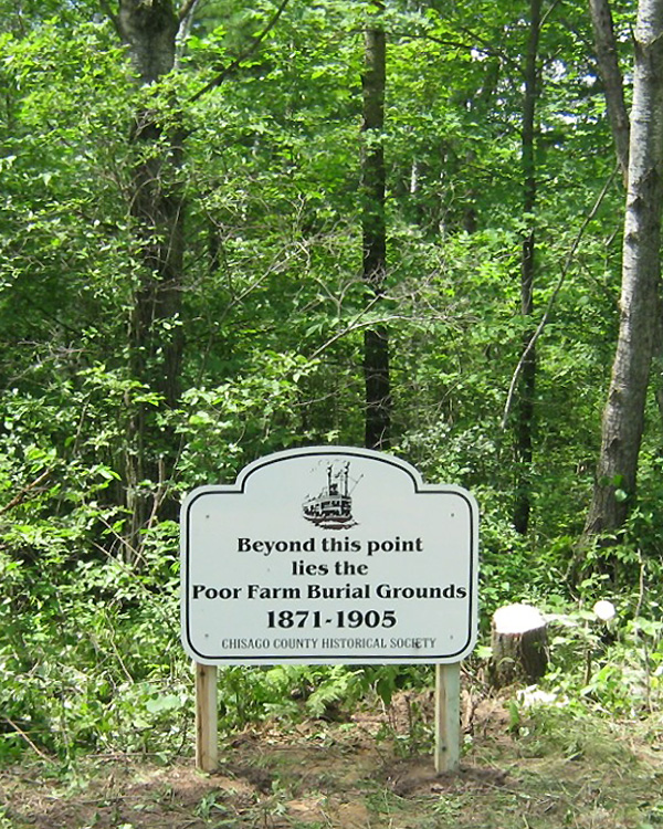
| Description | : | CHISAGO COUNTY POOR FARM CEMETERY AKA: POTTER'S FIELD CEMETERY AKA: SUNRISE POOR FARM CEMETERY A financial section article in the 10-Apr-1869 issue of the Taylors Falls Reporter. newspaper shows the purchase of 80 acres of land at the cost of $320 to be used for construction of the county poor farm. This real estate transaction was recorded on 4-Sep-1868. Chisago County government records show the Sunrise Poor Farm began operation about 1871. The 1885 MN state census lists 6 residents under the supervision of Oscar and Hannah Erickson, the caretakers who lived there along with their daughter Elida, age 3. The death records in the... Read More |
frequently asked questions (FAQ):
-
Where is Poor Farm Cemetery?
Poor Farm Cemetery is located at Sunrise, Chisago County ,Minnesota ,USA.
-
Poor Farm Cemetery cemetery's updated grave count on graveviews.com?
0 memorials
-
Where are the coordinates of the Poor Farm Cemetery?
Latitude: 45.5203018
Longitude: -92.8470993
Nearby Cemetories:
1. Kost Cemetery
Kost, Chisago County, USA
Coordinate: 45.4892006, -92.8696976
2. Sunrise Cemetery
Sunrise, Chisago County, USA
Coordinate: 45.5558014, -92.8563995
3. Almelund Cemetery
Almelund, Chisago County, USA
Coordinate: 45.4916992, -92.7845001
4. Poor Farm Cemetery
North Branch, Chisago County, USA
Coordinate: 45.5062190, -92.9493780
5. Wolf Creek Cemetery
Wolf Creek, Polk County, USA
Coordinate: 45.5594200, -92.7235600
6. Old Settlers Cemetery
Wolf Creek, Polk County, USA
Coordinate: 45.5996800, -92.7698200
7. Trinity Lutheran Cemetery
North Branch, Chisago County, USA
Coordinate: 45.5144997, -92.9872971
8. Oak Grove Cemetery
Harris, Chisago County, USA
Coordinate: 45.5614014, -92.9756012
9. Oak Hill Cemetery
North Branch, Chisago County, USA
Coordinate: 45.5129166, -92.9902344
10. Saint Josephs Catholic Cemetery
North Branch, Chisago County, USA
Coordinate: 45.5129013, -92.9915009
11. Pioneer Cemetery
Wolf Creek, Polk County, USA
Coordinate: 45.5819500, -92.7165410
12. Covenant Cemetery
Harris, Chisago County, USA
Coordinate: 45.5793991, -92.9847031
13. Old Lutheran Cemetery
Harris, Chisago County, USA
Coordinate: 45.5858994, -92.9825974
14. Chisago Lake Hillside Cemetery
Center City, Chisago County, USA
Coordinate: 45.3983994, -92.8143997
15. Chisago Lake Cemetery
Center City, Chisago County, USA
Coordinate: 45.3969002, -92.8135986
16. Fairview Cemetery
Lindstrom, Chisago County, USA
Coordinate: 45.3899994, -92.8349991
17. Methodist Cemetery
Center City, Chisago County, USA
Coordinate: 45.3888016, -92.8217010
18. Pleasant Hill Cemetery
Eureka Center, Polk County, USA
Coordinate: 45.4897003, -92.6517029
19. Stacy Cemetery
Stacy, Chisago County, USA
Coordinate: 45.4113998, -92.9788971
20. Cushing Cemetery
Cushing, Polk County, USA
Coordinate: 45.5691900, -92.6487900
21. Spring Lake Cemetery
Spring Lake, Isanti County, USA
Coordinate: 45.5429000, -93.0567000
22. Glader Cemetery
Lindstrom, Chisago County, USA
Coordinate: 45.3706017, -92.8217010
23. Fish Lake Lutheran Pioneer Cemetery
Stark, Chisago County, USA
Coordinate: 45.5777016, -93.0549011
24. Fish Lake Lutheran Cemetery
Stark, Chisago County, USA
Coordinate: 45.5777200, -93.0566020