
| Memorials | : | 0 |
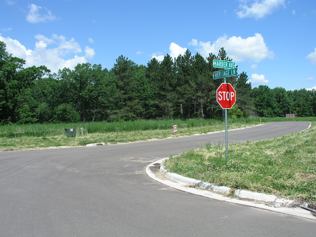
| Location | : | North Branch, Chisago County, USA |
| Coordinate | : | 45.5062190, -92.9493780 |
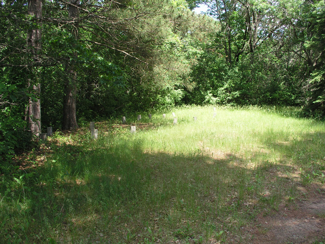
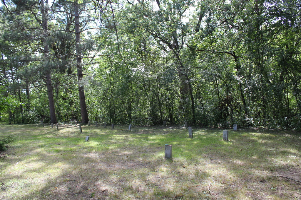
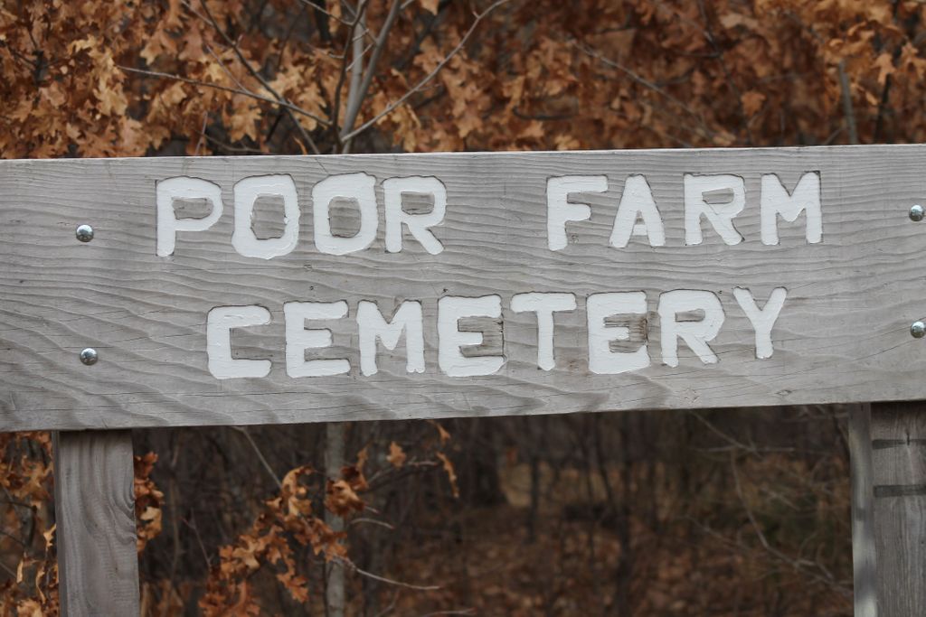
| Description | : | There has been a Christian tradition to provide Almshouses for those individuals who, for a variety of reasons, could not support themselves. These facilities were often referred to as "The Poor House". Historical information about this early social service system can be found on the internet and Wikipedia: Almshouses Poorhouses County Poor Farms held the destitute, indigent, and elderly. The residents lived a minimal existence where the physically capable individuals worked county-owned land and farmed crops to help provide their own sustenance. This is the second Chisago County Poor Farm, established about 1885, two miles east of North Branch, MN. During the first... Read More |
frequently asked questions (FAQ):
-
Where is Poor Farm Cemetery?
Poor Farm Cemetery is located at North Branch, Chisago County ,Minnesota ,USA.
-
Poor Farm Cemetery cemetery's updated grave count on graveviews.com?
0 memorials
-
Where are the coordinates of the Poor Farm Cemetery?
Latitude: 45.5062190
Longitude: -92.9493780
Nearby Cemetories:
1. Trinity Lutheran Cemetery
North Branch, Chisago County, USA
Coordinate: 45.5144997, -92.9872971
2. Oak Hill Cemetery
North Branch, Chisago County, USA
Coordinate: 45.5129166, -92.9902344
3. Saint Josephs Catholic Cemetery
North Branch, Chisago County, USA
Coordinate: 45.5129013, -92.9915009
4. Oak Grove Cemetery
Harris, Chisago County, USA
Coordinate: 45.5614014, -92.9756012
5. Kost Cemetery
Kost, Chisago County, USA
Coordinate: 45.4892006, -92.8696976
6. Poor Farm Cemetery
Sunrise, Chisago County, USA
Coordinate: 45.5203018, -92.8470993
7. Covenant Cemetery
Harris, Chisago County, USA
Coordinate: 45.5793991, -92.9847031
8. Sunrise Cemetery
Sunrise, Chisago County, USA
Coordinate: 45.5558014, -92.8563995
9. Old Lutheran Cemetery
Harris, Chisago County, USA
Coordinate: 45.5858994, -92.9825974
10. Spring Lake Cemetery
Spring Lake, Isanti County, USA
Coordinate: 45.5429000, -93.0567000
11. Saint Johns Cemetery
Weber, Isanti County, USA
Coordinate: 45.4981003, -93.0710983
12. Salem Lutheran Church Cemetery
Isanti County, USA
Coordinate: 45.4561500, -93.0626400
13. Stacy Cemetery
Stacy, Chisago County, USA
Coordinate: 45.4113998, -92.9788971
14. Fish Lake Lutheran Pioneer Cemetery
Stark, Chisago County, USA
Coordinate: 45.5777016, -93.0549011
15. Fish Lake Lutheran Cemetery
Stark, Chisago County, USA
Coordinate: 45.5777200, -93.0566020
16. Oxford Union Cemetery
Isanti County, USA
Coordinate: 45.4566994, -93.0914001
17. Almelund Cemetery
Almelund, Chisago County, USA
Coordinate: 45.4916992, -92.7845001
18. Fairview Cemetery
Lindstrom, Chisago County, USA
Coordinate: 45.3899994, -92.8349991
19. Big Meadow Cemetery
Isanti, Isanti County, USA
Coordinate: 45.5047200, -93.1529100
20. Chisago Lake Hillside Cemetery
Center City, Chisago County, USA
Coordinate: 45.3983994, -92.8143997
21. Chisago Lake Cemetery
Center City, Chisago County, USA
Coordinate: 45.3969002, -92.8135986
22. Methodist Cemetery
Center City, Chisago County, USA
Coordinate: 45.3888016, -92.8217010
23. Jonason Farm Cemetery
Stark, Chisago County, USA
Coordinate: 45.5884000, -93.1250500
24. Fish Lake Baptist Cemetery
Stark, Chisago County, USA
Coordinate: 45.6058006, -93.1177979