
| Memorials | : | 0 |
| Location | : | Mills County, USA |
| Coordinate | : | 40.9236100, -95.7086100 |
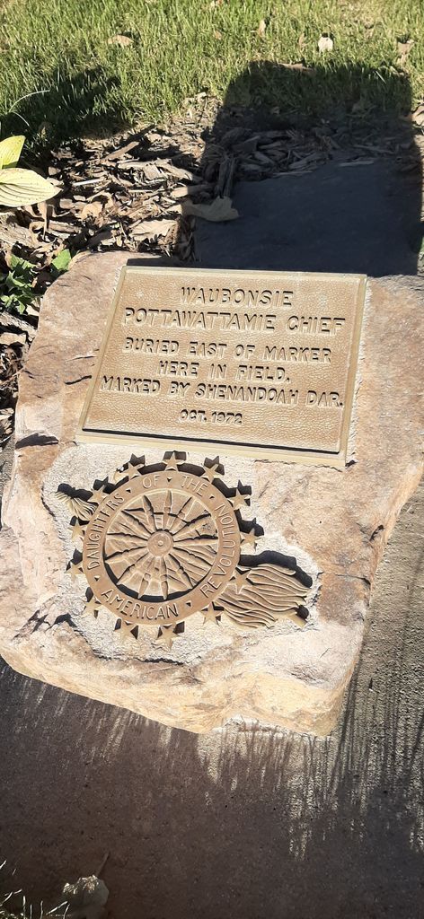
| Description | : | This burial site is on private land and is not accessible to the public. The grave of Chief Waubonsie near Tabor in Mills County Iowa, is a National Historical Marker. |
frequently asked questions (FAQ):
-
Where is Pottawattamie Chief Waubonsie Burial Site?
Pottawattamie Chief Waubonsie Burial Site is located at Mills County ,Iowa ,USA.
-
Pottawattamie Chief Waubonsie Burial Site cemetery's updated grave count on graveviews.com?
0 memorials
-
Where are the coordinates of the Pottawattamie Chief Waubonsie Burial Site?
Latitude: 40.9236100
Longitude: -95.7086100
Nearby Cemetories:
1. Estes Cemetery
Tabor, Mills County, USA
Coordinate: 40.9425011, -95.7080994
2. Rhodes Cemetery
Tabor, Fremont County, USA
Coordinate: 40.9011002, -95.7097015
3. Waubonsie Cemetery
Mills County, USA
Coordinate: 40.9451370, -95.7310791
4. Tabor Cemetery
Tabor, Mills County, USA
Coordinate: 40.9035260, -95.6799460
5. Mackey Cemetery
Glenwood, Mills County, USA
Coordinate: 40.9017070, -95.7376100
6. Walnut Hill Cemetery
Mills County, USA
Coordinate: 40.9232900, -95.7517100
7. Fairview Cemetery
Tabor, Mills County, USA
Coordinate: 40.9453011, -95.6716995
8. Ross Cemetery
Fremont County, USA
Coordinate: 40.8666700, -95.6808300
9. Van Eaton Cemetery
Pacific Junction, Mills County, USA
Coordinate: 40.9388800, -95.7919400
10. Gaylord Cemetery
Fremont County, USA
Coordinate: 40.8543200, -95.6705800
11. Thurman Cemetery
Thurman, Fremont County, USA
Coordinate: 40.8298721, -95.7339706
12. Hillsdale Cemetery
Glenwood, Mills County, USA
Coordinate: 41.0097008, -95.6427994
13. Ewell Cemetery
Fremont County, USA
Coordinate: 40.8250000, -95.7419500
14. Mount Zion Cemetery
Tabor, Fremont County, USA
Coordinate: 40.8290000, -95.6540000
15. Rock Bluff Cemetery
Plattsmouth, Cass County, USA
Coordinate: 40.9150009, -95.8469009
16. Kenosha Cemetery
Cass County, USA
Coordinate: 40.8750000, -95.8427963
17. Bomar Family Cemetery
Mills County, USA
Coordinate: 41.0369400, -95.6941700
18. Glenwood Resource Center Cemetery
Glenwood, Mills County, USA
Coordinate: 41.0361720, -95.7338590
19. Randolph Cemetery
Randolph, Fremont County, USA
Coordinate: 40.8769493, -95.5695038
20. Doom Family Cemetery
Cass County, USA
Coordinate: 40.9550000, -95.8575000
21. Malvern Cemetery
Malvern, Mills County, USA
Coordinate: 40.9886017, -95.5785980
22. Mills County Farm Cemetery
Glenwood, Mills County, USA
Coordinate: 41.0417930, -95.6756530
23. Duff Cemetery
Fremont County, USA
Coordinate: 40.8222200, -95.6002700
24. Acord Cemetery
Sidney, Fremont County, USA
Coordinate: 40.7930984, -95.6667023