
| Memorials | : | 3521 |
| Location | : | Malvern, Mills County, USA |
| Coordinate | : | 40.9886017, -95.5785980 |
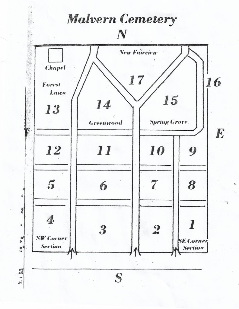
| Description | : | The Cemetery was formerly known as Silver Creek Burying Ground, Calvary Cemetery and Aurora Cemetery. On 12 March 1870 Henry & Mary Raines deeded to the trustees of the Silver Creek Burying Ground, for the sum of $ 5.00, and addition of the said graveyard, the dimensions described in the poles. Civil War Posts of the Grand Army of the Repulbic (Union) and the Works Progress Administration cemetery recording list burials a Calvary Cemetery. The 1891 & 1910 atlas show the name as Aurora and there was at one time an Aurora Cemetery Association. The first burial was Eliza Raines... Read More |
frequently asked questions (FAQ):
-
Where is Malvern Cemetery?
Malvern Cemetery is located at Malvern, Mills County ,Iowa ,USA.
-
Malvern Cemetery cemetery's updated grave count on graveviews.com?
535 memorials
-
Where are the coordinates of the Malvern Cemetery?
Latitude: 40.9886017
Longitude: -95.5785980
Nearby Cemetories:
1. Parker Cemetery
White Cloud, Mills County, USA
Coordinate: 40.9737649, -95.5184363
2. Hillsdale Cemetery
Glenwood, Mills County, USA
Coordinate: 41.0097008, -95.6427994
3. Wearin Cemetery
Malvern, Mills County, USA
Coordinate: 41.0395000, -95.5313000
4. Hastings Cemetery
Hastings, Mills County, USA
Coordinate: 41.0097008, -95.4993973
5. South Grove Cemetery
Mills County, USA
Coordinate: 40.9775009, -95.4931030
6. East Liberty Cemetery
Malvern, Mills County, USA
Coordinate: 41.0592346, -95.6005020
7. Fairview Cemetery
Tabor, Mills County, USA
Coordinate: 40.9453011, -95.6716995
8. Mills County Farm Cemetery
Glenwood, Mills County, USA
Coordinate: 41.0417930, -95.6756530
9. North Grove Cemetery
Hastings, Mills County, USA
Coordinate: 41.0161018, -95.4618988
10. Bomar Family Cemetery
Mills County, USA
Coordinate: 41.0369400, -95.6941700
11. Cotten Cemetery
Mills County, USA
Coordinate: 41.0845000, -95.5167000
12. Estes Cemetery
Tabor, Mills County, USA
Coordinate: 40.9425011, -95.7080994
13. Randolph Cemetery
Randolph, Fremont County, USA
Coordinate: 40.8769493, -95.5695038
14. Tabor Cemetery
Tabor, Mills County, USA
Coordinate: 40.9035260, -95.6799460
15. Riverside Cemetery
Randolph, Fremont County, USA
Coordinate: 40.8806000, -95.5269012
16. Pottawattamie Chief Waubonsie Burial Site
Mills County, USA
Coordinate: 40.9236100, -95.7086100
17. Waubonsie Cemetery
Mills County, USA
Coordinate: 40.9451370, -95.7310791
18. Silver City Cemetery
Silver City, Mills County, USA
Coordinate: 41.1042442, -95.6380005
19. Glenwood Resource Center Cemetery
Glenwood, Mills County, USA
Coordinate: 41.0361720, -95.7338590
20. Wesley Chapel Cemetery
Henderson, Mills County, USA
Coordinate: 41.1019249, -95.4987793
21. Rhodes Cemetery
Tabor, Fremont County, USA
Coordinate: 40.9011002, -95.7097015
22. Saylers Farm Cemetery
Henderson, Mills County, USA
Coordinate: 41.1083300, -95.4919440
23. Emerson Cemetery
Emerson, Mills County, USA
Coordinate: 41.0325012, -95.4021988
24. Ross Cemetery
Fremont County, USA
Coordinate: 40.8666700, -95.6808300