
| Memorials | : | 0 |
| Location | : | Lunsford, Craighead County, USA |
| Coordinate | : | 35.7566390, -90.4528330 |
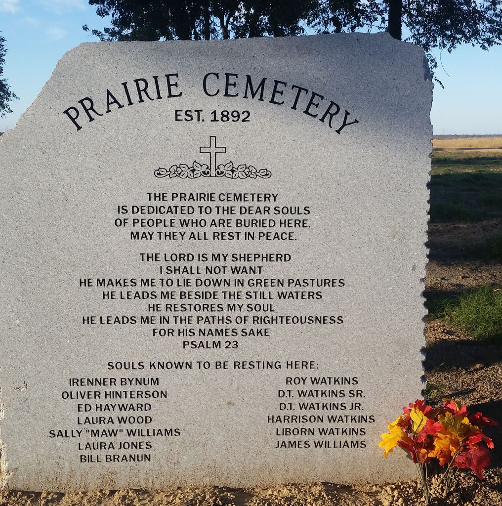
| Description | : | The cemetery is located at the junction of County Road 812 and County Road 815. It has been overgrown for years but a group of volunteers has cleaned it up and a Ground Penetrating Radar scan was used to find the location the Graves. They found 14 souls at rest here. Only a few could be identified since they matched the family burial knowledge of the placement of the graves and body size confirms it. There were three stones provided by the Mosaic Templars. Most of them are marked with a soul at rest marker to confirm the physical location of the... Read More |
frequently asked questions (FAQ):
-
Where is Prairie Cemetery?
Prairie Cemetery is located at Corner of CR 812 and CR 815 Lunsford, Craighead County ,Arkansas , 72437USA.
-
Prairie Cemetery cemetery's updated grave count on graveviews.com?
0 memorials
-
Where are the coordinates of the Prairie Cemetery?
Latitude: 35.7566390
Longitude: -90.4528330


Nearby Cemetories:
1. Wilson Cemetery
Bay, Craighead County, USA
Coordinate: 35.7139170, -90.4766110
2. Lake City Memorial Cemetery
Lake City, Craighead County, USA
Coordinate: 35.8097353, -90.4299793
3. Lake City Cemetery
Lake City, Craighead County, USA
Coordinate: 35.8133011, -90.4282990
4. Mangrum Cemetery
Mangrum, Craighead County, USA
Coordinate: 35.7900009, -90.3760986
5. Bowman Cemetery
Bowman, Craighead County, USA
Coordinate: 35.8270170, -90.4877190
6. Davis Spur Cemetery
Bay, Craighead County, USA
Coordinate: 35.7340460, -90.5517550
7. Lower Cane Island Cemetery
Lake City, Craighead County, USA
Coordinate: 35.8457985, -90.4308014
8. Caraway Cemetery
Caraway, Craighead County, USA
Coordinate: 35.7667007, -90.3407974
9. Black Oak Cemetery
Black Oak, Craighead County, USA
Coordinate: 35.8377570, -90.3690290
10. Upper Cane Island Cemetery
Craighead County, USA
Coordinate: 35.8706017, -90.4222031
11. Ridge View Mennonite Church Cemetery
Jonesboro, Craighead County, USA
Coordinate: 35.8101780, -90.5901150
12. Burrow Cemetery
Monette, Craighead County, USA
Coordinate: 35.8913994, -90.4119034
13. Tulot Cemetery
Poinsett County, USA
Coordinate: 35.6199989, -90.4831009
14. Monette Memorial Cemetery
Monette, Craighead County, USA
Coordinate: 35.8846092, -90.3494034
15. Potter Memorial Cemetery
Lepanto, Poinsett County, USA
Coordinate: 35.6166992, -90.3458023
16. Judd Hill Cemetery
Judd Hill, Poinsett County, USA
Coordinate: 35.5972960, -90.5195550
17. White Cemetery
Craighead County, USA
Coordinate: 35.7127991, -90.6613998
18. Nichols Cemetery
Marked Tree, Poinsett County, USA
Coordinate: 35.5922000, -90.3767000
19. First Missionary Baptist Church Cemetery
Lepanto, Poinsett County, USA
Coordinate: 35.6061870, -90.3356890
20. Pine Rest Cemetery
Lepanto, Poinsett County, USA
Coordinate: 35.6035995, -90.3364029
21. Brookland Methodist Cemetery
Brookland, Craighead County, USA
Coordinate: 35.9015160, -90.5847330
22. Hawkins Cemetery
Mississippi County, USA
Coordinate: 35.6460991, -90.2755966
23. Garden Point Cemetery
Etowah, Mississippi County, USA
Coordinate: 35.7001700, -90.2379330
24. Nettleton Cemetery
Jonesboro, Craighead County, USA
Coordinate: 35.8422012, -90.6528015