
| Memorials | : | 24 |
| Location | : | Procious, Clay County, USA |
| Coordinate | : | 38.4928080, -81.1939270 |
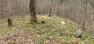
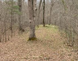
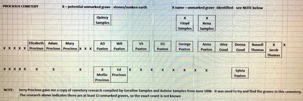
| Description | : | Twistabout Ridge, Clay, WV From Route 4 going toward Clay, turn right onto Twistabout Rd. Go .15 miles and turn right into a private driveway on the property of Brooks Burdette. Travel a short distance and go through a metal gate. Go .3 mile and go through another gate onto the property owned by Jerry Procious. The cemetery is about another .1 mile on the left side of the path, a short distance down over the hill in the woods. Info from Judy Burdette, Clay County historian. There are at least 13 unmarked graves. |
frequently asked questions (FAQ):
-
Where is Procious Cemetery?
Procious Cemetery is located at Procious, Clay County ,West Virginia ,USA.
-
Procious Cemetery cemetery's updated grave count on graveviews.com?
24 memorials
-
Where are the coordinates of the Procious Cemetery?
Latitude: 38.4928080
Longitude: -81.1939270

Nearby Cemetories:
1. Sam Samples Cemetery
Procious, Clay County, USA
Coordinate: 38.4868500, -81.1978430
2. Samples Harvey Cemetery
Procious, Clay County, USA
Coordinate: 38.4900060, -81.2049670
3. Park Cemetery
Procious, Clay County, USA
Coordinate: 38.4815030, -81.1804250
4. AJ Samples Cemetery
Procious, Clay County, USA
Coordinate: 38.4791450, -81.1783220
5. Reed Walker McCune Cemetery
Procious, Clay County, USA
Coordinate: 38.4898510, -81.2200680
6. Lee Cemetery
Bomont, Clay County, USA
Coordinate: 38.4767480, -81.2218030
7. Blessed Hope Advent Christian Church Cemetery
Bomont, Clay County, USA
Coordinate: 38.4775990, -81.2238210
8. Foreman Cemetery
Procious, Clay County, USA
Coordinate: 38.4935660, -81.2351740
9. Boone Samples Cemetery
Bomont, Clay County, USA
Coordinate: 38.4692820, -81.2232760
10. Wyant Cemetery
Ovapa, Clay County, USA
Coordinate: 38.5161770, -81.1569900
11. Pierson Cemetery
Elkhurst, Clay County, USA
Coordinate: 38.4636100, -81.1538900
12. Pierson Cemetery
Clay, Clay County, USA
Coordinate: 38.4636130, -81.1536220
13. Hill Cemetery
Amma, Roane County, USA
Coordinate: 38.5359890, -81.1981760
14. Small Cemetery
Procious, Clay County, USA
Coordinate: 38.4474408, -81.1880998
15. Hall Cemetery
Clay County, USA
Coordinate: 38.5311012, -81.1605988
16. Davis Cemetery
Clay County, USA
Coordinate: 38.4638590, -81.1472560
17. Belcher Cemetery
Ovapa, Clay County, USA
Coordinate: 38.5260640, -81.1519610
18. Wash King Cemetery
Bomont, Clay County, USA
Coordinate: 38.4461110, -81.2018930
19. Ovapa Church of God Cemetery
Ovapa, Clay County, USA
Coordinate: 38.5259680, -81.1470270
20. Blue Knob Church Cemetery
Maysel, Clay County, USA
Coordinate: 38.4703320, -81.1332710
21. Smith Cemetery
Clendenin, Kanawha County, USA
Coordinate: 38.4991989, -81.2608032
22. Joe Butcher Cemetery
Maysel, Clay County, USA
Coordinate: 38.4962070, -81.1261580
23. Bostic Family Cemetery
Bomont, Clay County, USA
Coordinate: 38.4551584, -81.2454482
24. Cogar Cemetery
Bomont, Clay County, USA
Coordinate: 38.4516730, -81.2463000