
| Memorials | : | 0 |
| Location | : | Randers, Randers Kommune, Denmark |
| Coordinate | : | 56.4741800, 10.0692300 |
| Description | : | N 56° 27.912 E 010° 02.836 |
frequently asked questions (FAQ):
-
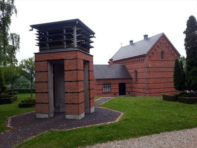
Where is Randers Eastern Cemetery?
Randers Eastern Cemetery is located at Østre Kirkegård Randers NØ 8930 Randers Kirkegård Randers, Randers Kommune ,Midtjylland ,Denmark.
-
Randers Eastern Cemetery cemetery's updated grave count on graveviews.com?
0 memorials
-
Where are the coordinates of the Randers Eastern Cemetery?
Latitude: 56.4741800
Longitude: 10.0692300
Nearby Cemetories:
1. Randers North Cemetery
Randers, Randers Kommune, Denmark
Coordinate: 56.4743500, 10.0395400
2. Kristrup Cemetery
Randers, Randers Kommune, Denmark
Coordinate: 56.4427530, 10.0647430
3. Hvidsten Mindelund Kirkegård
Hvidsten, Randers Kommune, Denmark
Coordinate: 56.5530000, 10.0018000
4. Sct. Pauls kirkegård
Hadsten, Favrskov Kommune, Denmark
Coordinate: 56.3292496, 10.0443639
5. Granslev
Aarhus, Arhus Kommune, Denmark
Coordinate: 56.3333333, 9.9166667
6. Auning Kirke and Scheelske Tomb Chapel
Auning, Norddjurs Kommune, Denmark
Coordinate: 56.4349770, 10.3769300
7. Mariager Cemetery
Mariager, Mariagerfjord Kommune, Denmark
Coordinate: 56.6481661, 9.9796222
8. Ørum Kirke og Kirkegård
Ørum, Viborg Kommune, Denmark
Coordinate: 56.4826963, 9.6297221
9. Hjortshøj Kirke
Aarhus, Arhus Kommune, Denmark
Coordinate: 56.2526150, 10.2658140
10. Gulev Kirke
Bjerringbro, Viborg Kommune, Denmark
Coordinate: 56.3507800, 9.6787000
11. Cemetery Vejby Risskov
Risskov, Arhus Kommune, Denmark
Coordinate: 56.1955060, 10.2119820
12. Lyngby Kirke
Aarhus, Arhus Kommune, Denmark
Coordinate: 56.1711060, 10.0415580
13. Nordre Kirkegård
Aarhus, Arhus Kommune, Denmark
Coordinate: 56.1675360, 10.2152930
14. Odder Family Cemetery
Juelsminde, Hedensted Kommune, Denmark
Coordinate: 56.1621860, 10.2059560
15. Ravnkilde Cemetery
Ravnkilde, Rebild Kommune, Denmark
Coordinate: 56.7560900, 9.7557299
16. Asmild kirkegård
Viborg, Viborg Kommune, Denmark
Coordinate: 56.4469372, 9.4251526
17. Lemming Kirke Cemetery
Viborg, Viborg Kommune, Denmark
Coordinate: 56.2500000, 9.5333330
18. Levring Kirkegård
Levring, Silkeborg Kommune, Denmark
Coordinate: 56.3065800, 9.4676200
19. Aarestrup Churchyard
Arestrup, Rebild Kommune, Denmark
Coordinate: 56.8192200, 9.7462800
20. Hørup Kirkegård
Horup, Silkeborg Kommune, Denmark
Coordinate: 56.2944100, 9.4382400
21. Rosmus Church Cemetery
Rosmus, Syddjurs Kommune, Denmark
Coordinate: 56.3034833, 10.7741167
22. Hoed Church Cemetery
Hoed, Syddjurs Kommune, Denmark
Coordinate: 56.3141952, 10.8169251
23. Thorning Kirkegård
Torning, Silkeborg Kommune, Denmark
Coordinate: 56.2865900, 9.3334400
24. Års kirkegård
Aars, Vesthimmerland Kommune, Denmark
Coordinate: 56.8050140, 9.5139950