
| Memorials | : | 0 |
| Location | : | Rosmus, Syddjurs Kommune, Denmark |
| Phone | : | *45 86 33 73 89 |
| Website | : | www.tirstrup-fuglslev-hyllested-rosmus-sogn.dk/om-kirkerne/rosmus-kirke/ |
| Coordinate | : | 56.3034833, 10.7741167 |
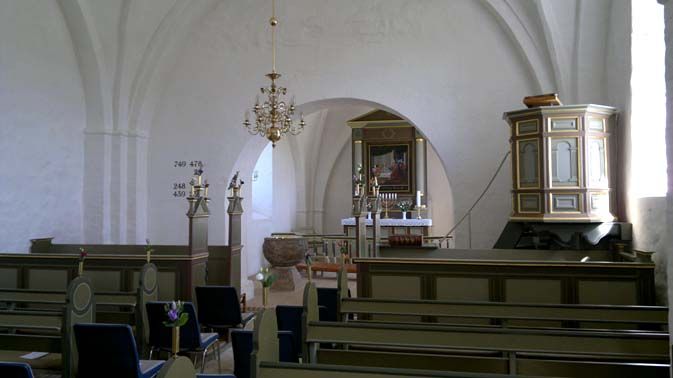
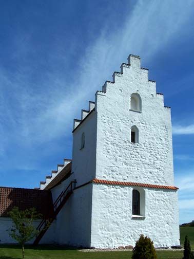
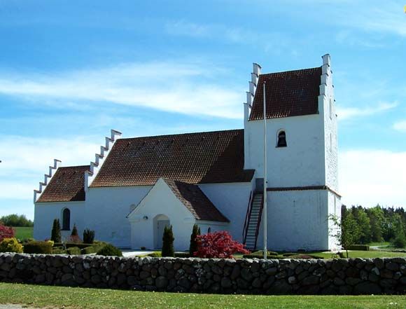
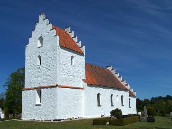
| Description | : | The white washed chalk stone church is set on a small hill over looking fields and a few of the village farms and houses. The church it self was build by bishop Svend of Århus or possibly one of his earlier relatives. In 1177 Svend, who owned a lot of land on Djursland, wrote a will, passing on his lands at Rosmus, Attrup, Ørup, Eringrude and Hyllestedrude to the cisterian monks of Øm Monastery near Ry in midt Jutland. It was named "Vor Frue Kirke" (Virgin Mary) by the monks. The tower was build in... Read More |
frequently asked questions (FAQ):
-
Where is Rosmus Church Cemetery?
Rosmus Church Cemetery is located at Rosmus Bygade 26 Rosmus, Syddjurs Kommune ,Midtjylland , 8444 BalleDenmark.
-
Rosmus Church Cemetery cemetery's updated grave count on graveviews.com?
0 memorials
-
Where are the coordinates of the Rosmus Church Cemetery?
Latitude: 56.3034833
Longitude: 10.7741167
Nearby Cemetories:
1. Hoed Church Cemetery
Hoed, Syddjurs Kommune, Denmark
Coordinate: 56.3141952, 10.8169251
2. Auning Kirke and Scheelske Tomb Chapel
Auning, Norddjurs Kommune, Denmark
Coordinate: 56.4349770, 10.3769300
3. Hjortshøj Kirke
Aarhus, Arhus Kommune, Denmark
Coordinate: 56.2526150, 10.2658140
4. Cemetery Vejby Risskov
Risskov, Arhus Kommune, Denmark
Coordinate: 56.1955060, 10.2119820
5. Nordre Kirkegård
Aarhus, Arhus Kommune, Denmark
Coordinate: 56.1675360, 10.2152930
6. Odder Family Cemetery
Juelsminde, Hedensted Kommune, Denmark
Coordinate: 56.1621860, 10.2059560
7. Sct. Pauls kirkegård
Hadsten, Favrskov Kommune, Denmark
Coordinate: 56.3292496, 10.0443639
8. Kristrup Cemetery
Randers, Randers Kommune, Denmark
Coordinate: 56.4427530, 10.0647430
9. Randers Eastern Cemetery
Randers, Randers Kommune, Denmark
Coordinate: 56.4741800, 10.0692300
10. Lyngby Kirke
Aarhus, Arhus Kommune, Denmark
Coordinate: 56.1711060, 10.0415580
11. Randers North Cemetery
Randers, Randers Kommune, Denmark
Coordinate: 56.4743500, 10.0395400
12. Besser Kirke
Aarhus, Arhus Kommune, Denmark
Coordinate: 55.8524220, 10.6295840
13. Odder Sogns Churchyard
Odder, Odder Kommune, Denmark
Coordinate: 55.9783302, 10.1496408
14. Granslev
Aarhus, Arhus Kommune, Denmark
Coordinate: 56.3333333, 9.9166667
15. Tranebjerg Churchyard
Tranebjerg, Samsø Kommune, Denmark
Coordinate: 55.8346500, 10.5866900
16. Odden Kirke
Overby, Odsherred Kommune, Denmark
Coordinate: 55.9572370, 11.4024570
17. Hvidsten Mindelund Kirkegård
Hvidsten, Randers Kommune, Denmark
Coordinate: 56.5530000, 10.0018000
18. Mariager Cemetery
Mariager, Mariagerfjord Kommune, Denmark
Coordinate: 56.6481661, 9.9796222
19. Hojby Church Cemetery
Hojby, Odsherred Kommune, Denmark
Coordinate: 55.9128130, 11.6003050
20. Gulev Kirke
Bjerringbro, Viborg Kommune, Denmark
Coordinate: 56.3507800, 9.6787000
21. Fårevejle Church Cemetery
Farevejle, Odsherred Kommune, Denmark
Coordinate: 55.8025840, 11.4439750
22. Asnæs Church Cemetery
Holbaek, Holbæk Kommune, Denmark
Coordinate: 55.8097200, 11.4985480
23. Ørum Kirke og Kirkegård
Ørum, Viborg Kommune, Denmark
Coordinate: 56.4826963, 9.6297221
24. Vissing
Randers, Randers Kommune, Denmark
Coordinate: 56.0230556, 9.6422222