
| Memorials | : | 2 |
| Location | : | Iberia, Miller County, USA |
| Coordinate | : | 38.0666100, -92.3588000 |
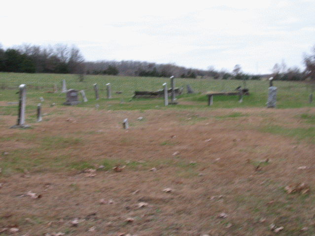
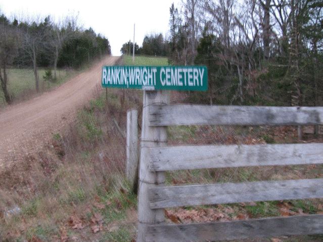
| Description | : | From Iberia, take Hwy EE and go 2.6 miles to Cottonwood Rd. Turn right on Cottonwood Rd and go 1.2 miles and you will see a sign on the right side of the road that says Rankin-Wright Cemetery. Go through the gate, it is a long lane through a pasture, for about 3 or 4 tenths of a mile and the cemetery is on the right. This cemetery is in bad shape. The weeds are chest high, which makes it difficult to find the head stones. For some reason the other compilers called this the Spearman Cemetery. |
frequently asked questions (FAQ):
-
Where is Rankin Wright Cemetery?
Rankin Wright Cemetery is located at Richwood Township: Section 33, Township 39 North, Range 13 West, Miller County, MO. Iberia, Miller County ,Missouri ,USA.
-
Rankin Wright Cemetery cemetery's updated grave count on graveviews.com?
2 memorials
-
Where are the coordinates of the Rankin Wright Cemetery?
Latitude: 38.0666100
Longitude: -92.3588000
Nearby Cemetories:
1. Oak View Cemetery
Iberia, Miller County, USA
Coordinate: 38.0608700, -92.3375300
2. Pleasant Hill Christian Church Cemetery
Iberia, Miller County, USA
Coordinate: 38.0479800, -92.3376400
3. Curry Cemetery
Iberia, Miller County, USA
Coordinate: 38.0464400, -92.3917400
4. Williams Cemetery
Miller County, USA
Coordinate: 38.0791900, -92.4043800
5. Ralph Duncan Farm Cemetery
Miller County, USA
Coordinate: 38.0249300, -92.3354300
6. Madden Cemetery
Miller County, USA
Coordinate: 38.0388010, -92.3073630
7. Tallman Cemetery
Miller County, USA
Coordinate: 38.0644800, -92.2902700
8. Bievans Cemetery
Miller County, USA
Coordinate: 38.0654090, -92.2877100
9. Hickory Point Cemetery
Iberia, Miller County, USA
Coordinate: 38.1239200, -92.3824700
10. Mount Union Cemetery
Brumley, Miller County, USA
Coordinate: 38.0614200, -92.4375400
11. Iberia Cemetery
Iberia, Miller County, USA
Coordinate: 38.0911680, -92.2839720
12. Hawkeye Cemetery
Hawkeye, Pulaski County, USA
Coordinate: 38.0024900, -92.3937300
13. Livingston Cemetery
Iberia, Miller County, USA
Coordinate: 38.1368700, -92.3401200
14. Ralph Christeson Farm Cemetery
Crocker, Pulaski County, USA
Coordinate: 37.9998827, -92.3149395
15. Miles Cemetery
Pulaski County, USA
Coordinate: 37.9916992, -92.3807983
16. Billingsley Cemetery
Iberia, Miller County, USA
Coordinate: 38.0756342, -92.2600151
17. Concord Cemetery
Crocker, Pulaski County, USA
Coordinate: 37.9871400, -92.3566100
18. Hawkins Cemetery
Brumley, Miller County, USA
Coordinate: 38.1006012, -92.4567032
19. Reed Family Cemetery
Miller County, USA
Coordinate: 38.1285095, -92.4371567
20. Jarrett Cemetery
Iberia, Miller County, USA
Coordinate: 38.1475300, -92.3125300
21. Bethany Memorial Gardens
Crocker, Pulaski County, USA
Coordinate: 38.0091070, -92.2635760
22. Pemberton Cemetery
Pulaski County, USA
Coordinate: 37.9763985, -92.4013977
23. Martin Family Cemetery
Miller County, USA
Coordinate: 38.1442500, -92.4374600
24. Gott Cemetery
Ulman, Miller County, USA
Coordinate: 38.1231290, -92.4656910