
| Memorials | : | 570 |
| Location | : | Rawtenstall, Rossendale Borough, England |
| Coordinate | : | 53.7060200, -2.2847500 |
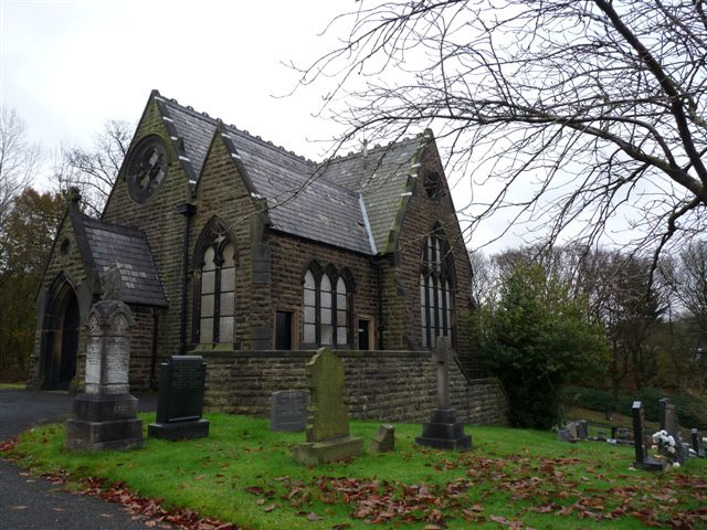
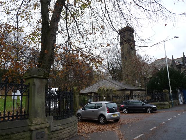
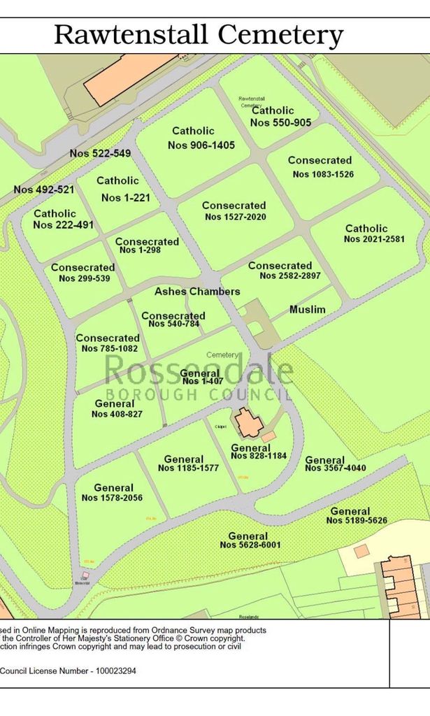
| Description | : | The first burial in Rawtenstall Cemetery took place in January 1877. The cemetery currently holds over 21,000 burials and this site also covers around 17 acres. A recently renovated chapel sits within the cemetery seating about 40 people and can be hired on payment of a small fee. The cemetery is located only a short walk from Rawtenstall's market place and caters for Catholic, Church of England, Non Conformist and Muslim burials. |
frequently asked questions (FAQ):
-
Where is Rawtenstall Cemetery?
Rawtenstall Cemetery is located at Rawtenstall, Rossendale Borough ,Lancashire ,England.
-
Rawtenstall Cemetery cemetery's updated grave count on graveviews.com?
533 memorials
-
Where are the coordinates of the Rawtenstall Cemetery?
Latitude: 53.7060200
Longitude: -2.2847500
Nearby Cemetories:
1. Unitarian Chapel Burial Ground
Rossendale, Rossendale Borough, England
Coordinate: 53.7024380, -2.2856290
2. Longholme Methodist Cemetery
Rawtenstall, Rossendale Borough, England
Coordinate: 53.7009730, -2.2865000
3. Friends Burial Ground
Rossendale, Rossendale Borough, England
Coordinate: 53.7091000, -2.2757160
4. Broadleys Garden
Rawtenstall, Rossendale Borough, England
Coordinate: 53.7176321, -2.2904764
5. Burnley Road Cemetery, Reedsholme, Rossendale
Rossendale Borough, England
Coordinate: 53.7178398, -2.2904316
6. Crawshawbooth Quaker Burial Ground
Crawshawbooth, Rossendale Borough, England
Coordinate: 53.7242420, -2.2879400
7. Bethlehem Chapel Graveyard
Newchurch, Rossendale Borough, England
Coordinate: 53.6976970, -2.2522620
8. St. Nicholas Churchyard
Newchurch, Rossendale Borough, England
Coordinate: 53.6972220, -2.2524660
9. Saint Anne's Churchyard Edgeside
Waterfoot, Rossendale Borough, England
Coordinate: 53.7031600, -2.2482700
10. Newchurch Methodist Churchyard
Newchurch, Rossendale Borough, England
Coordinate: 53.6983460, -2.2501260
11. Ebenezer Baptist Chapel Chapelyard
Haslingden, Rossendale Borough, England
Coordinate: 53.7053960, -2.3230070
12. King Street Methodist Chapel Chapelyard
Haslingden, Rossendale Borough, England
Coordinate: 53.7066710, -2.3231330
13. St James Churchyard
Haslingden, Rossendale Borough, England
Coordinate: 53.7084000, -2.3259550
14. St. Mary and All Saints Churchyard
Goodshaw, Rossendale Borough, England
Coordinate: 53.7315270, -2.2828940
15. Saint Michael on the Hill Churchyard
Lumb, Rossendale Borough, England
Coordinate: 53.7201000, -2.2479300
16. Goodshaw Particular Baptist Chapel Graveyard
Goodshaw, Rossendale Borough, England
Coordinate: 53.7328210, -2.2815530
17. Lumb Baptist Church Cemetery
Waterfoot, Rossendale Borough, England
Coordinate: 53.7229340, -2.2455170
18. Rehoboth Chapel
Goodshaw, Rossendale Borough, England
Coordinate: 53.7355870, -2.2914730
19. Saint Thomas Churchyard
Helmshore, Rossendale Borough, England
Coordinate: 53.6870400, -2.3300000
20. Edenfield Parish Churchyard
Ramsbottom, Metropolitan Borough of Bury, England
Coordinate: 53.6742799, -2.3069304
21. Holden Hall Cemetery
Haslingden, Rossendale Borough, England
Coordinate: 53.6989870, -2.3427780
22. Haslingden Cemetery
Haslingden, Rossendale Borough, England
Coordinate: 53.6989500, -2.3427700
23. Providence Free United Methodist Graveyard
Crawshawbooth, Rossendale Borough, England
Coordinate: 53.7442070, -2.2825700
24. Mount Pleasant Wesleyan Chapelyard
Bacup, Rossendale Borough, England
Coordinate: 53.6924900, -2.2228100