
| Memorials | : | 2 |
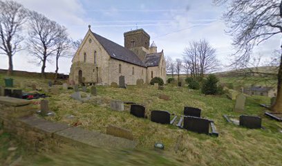
| Location | : | Lumb, Rossendale Borough, England |
| Coordinate | : | 53.7201000, -2.2479300 |
| Description | : | The cornerstone of the Church was laid on the 29th September 1847 and it was consecrated on December 9th 1848. It is a Grade II listed building. The first burial was a 5-day-old boy on 20th October 1849, and the last on 17th October 1982. St Michael’s was incorporated into St Nicholas Newchurch in 1985. The church was made redundant on 1st December 2001 and subsequently converted to residential accommodation. The present accessibility of the churchyard is not known. Further details, including baptism, marriage and burial register transcripts, memorial inscriptions, and a graveyard plan are at http://www.lan-opc.org.uk/Rossendale/Lumb/stmichael/index.html. The small number of MIs... Read More |
frequently asked questions (FAQ):
-
Where is Saint Michael on the Hill Churchyard?
Saint Michael on the Hill Churchyard is located at Burnley Road East Lumb, Rossendale Borough ,Lancashire , BB4England.
-
Saint Michael on the Hill Churchyard cemetery's updated grave count on graveviews.com?
2 memorials
-
Where are the coordinates of the Saint Michael on the Hill Churchyard?
Latitude: 53.7201000
Longitude: -2.2479300
Nearby Cemetories:
1. Lumb Baptist Church Cemetery
Waterfoot, Rossendale Borough, England
Coordinate: 53.7229340, -2.2455170
2. Saint Anne's Churchyard Edgeside
Waterfoot, Rossendale Borough, England
Coordinate: 53.7031600, -2.2482700
3. Friends Burial Ground
Rossendale, Rossendale Borough, England
Coordinate: 53.7091000, -2.2757160
4. Newchurch Methodist Churchyard
Newchurch, Rossendale Borough, England
Coordinate: 53.6983460, -2.2501260
5. Bethlehem Chapel Graveyard
Newchurch, Rossendale Borough, England
Coordinate: 53.6976970, -2.2522620
6. St. Nicholas Churchyard
Newchurch, Rossendale Borough, England
Coordinate: 53.6972220, -2.2524660
7. Goodshaw Particular Baptist Chapel Graveyard
Goodshaw, Rossendale Borough, England
Coordinate: 53.7328210, -2.2815530
8. St. Mary and All Saints Churchyard
Goodshaw, Rossendale Borough, England
Coordinate: 53.7315270, -2.2828940
9. Crawshawbooth Quaker Burial Ground
Crawshawbooth, Rossendale Borough, England
Coordinate: 53.7242420, -2.2879400
10. Burnley Road Cemetery, Reedsholme, Rossendale
Rossendale Borough, England
Coordinate: 53.7178398, -2.2904316
11. Broadleys Garden
Rawtenstall, Rossendale Borough, England
Coordinate: 53.7176321, -2.2904764
12. Rawtenstall Cemetery
Rawtenstall, Rossendale Borough, England
Coordinate: 53.7060200, -2.2847500
13. Unitarian Chapel Burial Ground
Rossendale, Rossendale Borough, England
Coordinate: 53.7024380, -2.2856290
14. Longholme Methodist Cemetery
Rawtenstall, Rossendale Borough, England
Coordinate: 53.7009730, -2.2865000
15. Rehoboth Chapel
Goodshaw, Rossendale Borough, England
Coordinate: 53.7355870, -2.2914730
16. Mount Pleasant Wesleyan Chapelyard
Bacup, Rossendale Borough, England
Coordinate: 53.6924900, -2.2228100
17. Providence Free United Methodist Graveyard
Crawshawbooth, Rossendale Borough, England
Coordinate: 53.7442070, -2.2825700
18. St John the Evangelist Churchyard
Bacup, Rossendale Borough, England
Coordinate: 53.7037300, -2.2019600
19. Ebenezer Particular Baptist Chapel Chapelyard
Bacup, Rossendale Borough, England
Coordinate: 53.7045700, -2.1997500
20. Bacup Cemetery
Bacup, Rossendale Borough, England
Coordinate: 53.6906780, -2.2156640
21. King Street Methodist Chapel Chapelyard
Haslingden, Rossendale Borough, England
Coordinate: 53.7066710, -2.3231330
22. Ebenezer Baptist Chapel Chapelyard
Haslingden, Rossendale Borough, England
Coordinate: 53.7053960, -2.3230070
23. St James Churchyard
Haslingden, Rossendale Borough, England
Coordinate: 53.7084000, -2.3259550
24. St. John the Divine Churchyard
Cliviger, Burnley Borough, England
Coordinate: 53.7533610, -2.1895090