
| Memorials | : | 0 |
| Location | : | Bristol Unitary Authority, England |
| Coordinate | : | 51.4563073, -2.5833100 |
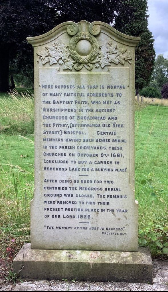
| Description | : | A plot of land in Red Cross Street was purchased jointly by the Broadmead and Old King Street Baptist chapels in 1679 for a burial ground, it closed about 1875, sold by the trustees, it no longer exists, between the 31st of May and the 20th July 1926 all the burials were moved to Greenbank Cemetery Grave No. 70-74 Blue N |
frequently asked questions (FAQ):
-
Where is Redcross Street Burial Ground (Defunct)?
Redcross Street Burial Ground (Defunct) is located at RedCross Street Bristol Unitary Authority ,Bristol ,England.
-
Redcross Street Burial Ground (Defunct) cemetery's updated grave count on graveviews.com?
0 memorials
-
Where are the coordinates of the Redcross Street Burial Ground (Defunct)?
Latitude: 51.4563073
Longitude: -2.5833100
Nearby Cemetories:
1. St Philip and St Jacob Churchyard
Bristol, Bristol Unitary Authority, England
Coordinate: 51.4545420, -2.5844690
2. Whitfield's Tabernacle
St Pauls, Bristol Unitary Authority, England
Coordinate: 51.4579500, -2.5860800
3. Black Friars Priory
Bristol, Bristol Unitary Authority, England
Coordinate: 51.4572220, -2.5877780
4. Quakers Friars Burial Ground
Bristol, Bristol Unitary Authority, England
Coordinate: 51.4572220, -2.5877780
5. St. Peter's Churchyard
Bristol, Bristol Unitary Authority, England
Coordinate: 51.4553560, -2.5896930
6. Barton Road Jewish Cemetery
St Phillips, Bristol Unitary Authority, England
Coordinate: 51.4531400, -2.5779800
7. Temple Church Churchyard
Redcliffe, Bristol Unitary Authority, England
Coordinate: 51.4521160, -2.5867630
8. Holy Trinity Church
St Phillips, Bristol Unitary Authority, England
Coordinate: 51.4580335, -2.5760701
9. Temple Churchyard
Bristol, Bristol Unitary Authority, England
Coordinate: 51.4520010, -2.5868870
10. St Pauls Churchyard
Bristol, Bristol Unitary Authority, England
Coordinate: 51.4611550, -2.5847190
11. Brunswick Square Unitarian Burying Ground
Bristol, Bristol Unitary Authority, England
Coordinate: 51.4605400, -2.5877800
12. Holy Trinity Church
Bristol, Bristol Unitary Authority, England
Coordinate: 51.4559548, -2.5915587
13. Broadmead Baptist Church
Bristol, Bristol Unitary Authority, England
Coordinate: 51.4575500, -2.5915500
14. St Nicholas Churchyard
Bristol, Bristol Unitary Authority, England
Coordinate: 51.4539170, -2.5923050
15. All Saints Church
Bristol, Bristol Unitary Authority, England
Coordinate: 51.4546990, -2.5932550
16. St. James Churchyard
Bristol, Bristol Unitary Authority, England
Coordinate: 51.4585510, -2.5932310
17. St. James Priory
Bristol, Bristol Unitary Authority, England
Coordinate: 51.4585220, -2.5936690
18. St Stephen's Churchyard
Bristol, Bristol Unitary Authority, England
Coordinate: 51.4535380, -2.5937270
19. Church of St John the Baptist
Bristol, Bristol Unitary Authority, England
Coordinate: 51.4559460, -2.5950320
20. Quaker Burial Ground
Redcliffe, Bristol Unitary Authority, England
Coordinate: 51.4486700, -2.5905900
21. St Mary the Virgin Churchyard
Redcliffe, Bristol Unitary Authority, England
Coordinate: 51.4482800, -2.5895460
22. St. Michael on the Mount Without Churchyard
Bristol, Bristol Unitary Authority, England
Coordinate: 51.4571510, -2.5984070
23. St. Mark's Church
Bristol, Bristol Unitary Authority, England
Coordinate: 51.4528770, -2.5999610
24. Bristol Cathedral
Bristol, Bristol Unitary Authority, England
Coordinate: 51.4517059, -2.6007321