
| Memorials | : | 0 |
| Location | : | St Pauls, Bristol Unitary Authority, England |
| Coordinate | : | 51.4579500, -2.5860800 |
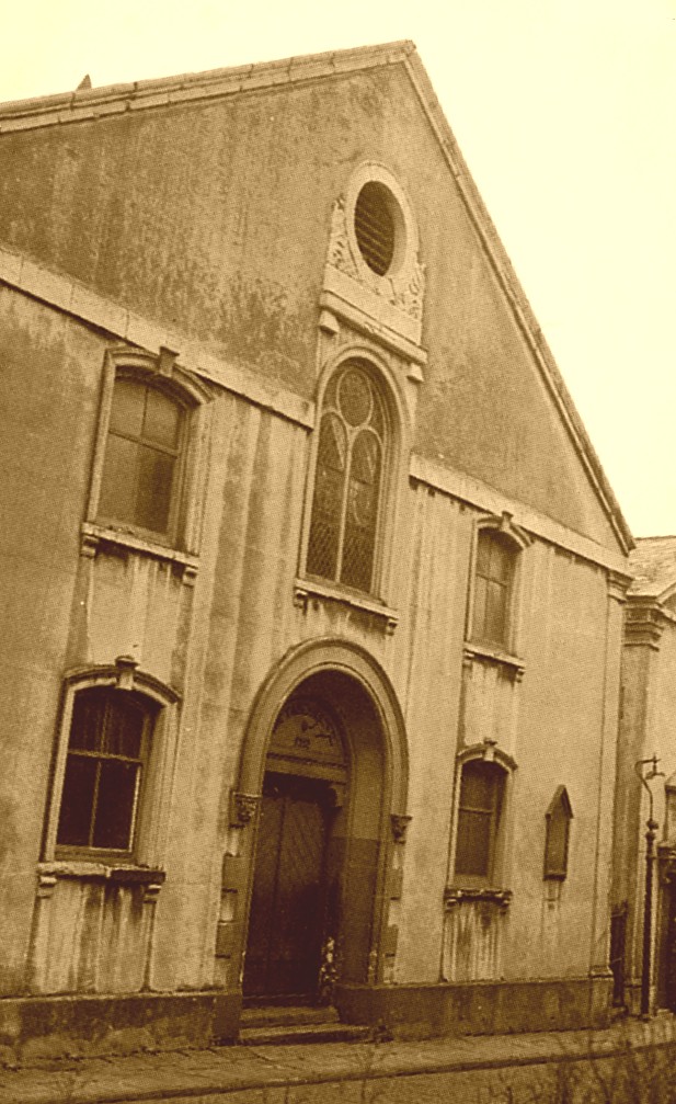
| Description | : | Whitfield's Tabernacle, which is also known as the Penn Street Tabernacle, was founded in 1752 by the Methodist preacher George Whitfield (also spelled Whitefield). The chapel stood until about 1970 when it was demolished. The burials at that time were left in a crypt at the spot where the chapel originally stood, but when the area was redeveloped about 2006 or 2007 the burials were moved elsewhere. It is believed that the remains were reburied at Canford Cemetery, but this is not known for certain. |
frequently asked questions (FAQ):
-
Where is Whitfield's Tabernacle?
Whitfield's Tabernacle is located at Penn Street St Pauls, Bristol Unitary Authority ,Bristol ,England.
-
Whitfield's Tabernacle cemetery's updated grave count on graveviews.com?
0 memorials
-
Where are the coordinates of the Whitfield's Tabernacle?
Latitude: 51.4579500
Longitude: -2.5860800
Nearby Cemetories:
1. Black Friars Priory
Bristol, Bristol Unitary Authority, England
Coordinate: 51.4572220, -2.5877780
2. Quakers Friars Burial Ground
Bristol, Bristol Unitary Authority, England
Coordinate: 51.4572220, -2.5877780
3. Redcross Street Burial Ground (Defunct)
Bristol Unitary Authority, England
Coordinate: 51.4563073, -2.5833100
4. Brunswick Square Unitarian Burying Ground
Bristol, Bristol Unitary Authority, England
Coordinate: 51.4605400, -2.5877800
5. St Pauls Churchyard
Bristol, Bristol Unitary Authority, England
Coordinate: 51.4611550, -2.5847190
6. Broadmead Baptist Church
Bristol, Bristol Unitary Authority, England
Coordinate: 51.4575500, -2.5915500
7. St. Peter's Churchyard
Bristol, Bristol Unitary Authority, England
Coordinate: 51.4553560, -2.5896930
8. St Philip and St Jacob Churchyard
Bristol, Bristol Unitary Authority, England
Coordinate: 51.4545420, -2.5844690
9. Holy Trinity Church
Bristol, Bristol Unitary Authority, England
Coordinate: 51.4559548, -2.5915587
10. St. James Churchyard
Bristol, Bristol Unitary Authority, England
Coordinate: 51.4585510, -2.5932310
11. St. James Priory
Bristol, Bristol Unitary Authority, England
Coordinate: 51.4585220, -2.5936690
12. All Saints Church
Bristol, Bristol Unitary Authority, England
Coordinate: 51.4546990, -2.5932550
13. St Nicholas Churchyard
Bristol, Bristol Unitary Authority, England
Coordinate: 51.4539170, -2.5923050
14. Temple Church Churchyard
Redcliffe, Bristol Unitary Authority, England
Coordinate: 51.4521160, -2.5867630
15. Church of St John the Baptist
Bristol, Bristol Unitary Authority, England
Coordinate: 51.4559460, -2.5950320
16. Temple Churchyard
Bristol, Bristol Unitary Authority, England
Coordinate: 51.4520010, -2.5868870
17. Holy Trinity Church
St Phillips, Bristol Unitary Authority, England
Coordinate: 51.4580335, -2.5760701
18. St Stephen's Churchyard
Bristol, Bristol Unitary Authority, England
Coordinate: 51.4535380, -2.5937270
19. Barton Road Jewish Cemetery
St Phillips, Bristol Unitary Authority, England
Coordinate: 51.4531400, -2.5779800
20. St. Michael on the Mount Without Churchyard
Bristol, Bristol Unitary Authority, England
Coordinate: 51.4571510, -2.5984070
21. Quaker Burial Ground
Redcliffe, Bristol Unitary Authority, England
Coordinate: 51.4486700, -2.5905900
22. St Mary the Virgin Churchyard
Redcliffe, Bristol Unitary Authority, England
Coordinate: 51.4482800, -2.5895460
23. St. Mark's Church
Bristol, Bristol Unitary Authority, England
Coordinate: 51.4528770, -2.5999610
24. Bristol Cathedral
Bristol, Bristol Unitary Authority, England
Coordinate: 51.4517059, -2.6007321