
| Memorials | : | 0 |
| Location | : | Tanum, Tanums kommun, Sweden |
| Coordinate | : | 58.8112080, 11.1851120 |
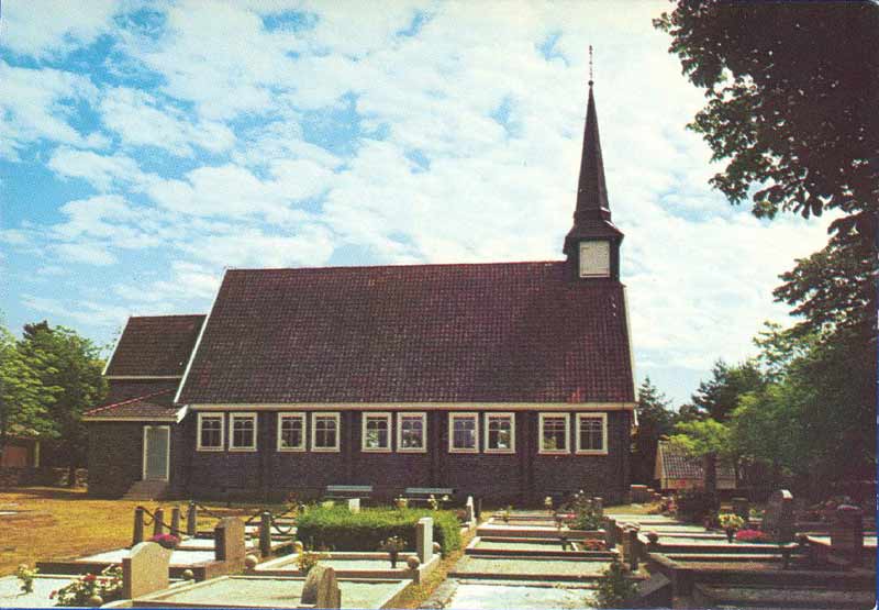
| Description | : | The Resö-Galtö kyrkogård dates back to the erection of the church between 1913-16. The first burial was reportedly, Hans Birger Berntsson (Jul. 18, 1917), who died young, at sea. Prior to this time most of the Resöbo burials were at Lur's Kyrka on the mainland. The church was restored to its original 1916 appearance, circa 2000. Resö kyrka - liten, ovanlig träkyrka, byggd med öbornas insamlade medel åren 1913-16. Ritningarna gjordes av byggmästarfirman A. & C. W. Gustafsson, Borås. Utvändigt är byggnaden klädd med sågade och tjärstrukna ekspån. Sadeltak av trä under rött tegel. Fönstersnickerierna är vit-målade. Invändigt har kapellet genomgått... Read More |
frequently asked questions (FAQ):
-
Where is Reso Galto?
Reso Galto is located at Kyrkviken, Resö. Tanum, Tanums kommun ,Västra Götalands län ,Sweden.
-
Reso Galto cemetery's updated grave count on graveviews.com?
0 memorials
-
Where are the coordinates of the Reso Galto?
Latitude: 58.8112080
Longitude: 11.1851120
Nearby Cemetories:
1. Lur's kyrkogård
Tanum, Tanums kommun, Sweden
Coordinate: 58.8186640, 11.3311100
2. Lurs Kyrka Gård
Lur, Tanums kommun, Sweden
Coordinate: 58.8186860, 11.3311100
3. Sydkoster kyrkogård
Strömstads kommun, Sweden
Coordinate: 58.8855170, 11.0237000
4. Grebbestad Kyrkogård
Tanum, Tanums kommun, Sweden
Coordinate: 58.6952440, 11.2524680
5. Myren
Strömstad, Strömstads kommun, Sweden
Coordinate: 58.9329880, 11.1835560
6. Tanumshede Kyrkogård
Tanumshede, Tanums kommun, Sweden
Coordinate: 58.7155130, 11.3333420
7. Strömstad kyrkogård
Strömstad, Strömstads kommun, Sweden
Coordinate: 58.9382520, 11.1750700
8. Naverstad Kyrkogård
Tanums kommun, Sweden
Coordinate: 58.7634830, 11.5671670
9. Hogdal kyrkogård
Hogdal, Strömstads kommun, Sweden
Coordinate: 59.0260830, 11.2301720
10. Fjällbacka Kyrkogård
Fjällbacka, Tanums kommun, Sweden
Coordinate: 58.6005191, 11.2845430
11. Stensholmen War Cemetery
Tanums kommun, Sweden
Coordinate: 58.5757500, 11.2746110
12. Kville Kyrkogård
Kville, Tanums kommun, Sweden
Coordinate: 58.5683290, 11.3668480
13. Idd kirke
Halden kommune, Norway
Coordinate: 59.0862840, 11.4346680
14. Solli gravlund
Halden kommune, Norway
Coordinate: 59.0954910, 11.4430320
15. Svenneby gamla
Svenneby, Tanums kommun, Sweden
Coordinate: 58.4997640, 11.3240520
16. Slavekirkegården
Oslo, Oslo kommune, Norway
Coordinate: 59.1135500, 11.4002833
17. Bottna kyrkogård
Tanums kommun, Sweden
Coordinate: 58.5042897, 11.3792237
18. Os gravlund
Halden, Halden kommune, Norway
Coordinate: 59.1284500, 11.3903300
19. Berg Church
Halden, Halden kommune, Norway
Coordinate: 59.1379563, 11.3292295
20. Asak kirkegård
Asak, Halden kommune, Norway
Coordinate: 59.1440900, 11.4541500
21. Hunnebostrand
Hunnebostrand, Sotenäs kommun, Sweden
Coordinate: 58.4448349, 11.3102999
22. Tossene Church
Tossene, Sotenäs kommun, Sweden
Coordinate: 58.4501804, 11.3683834
23. Hunnebostrands kyrkogård
Sotenäs kommun, Sweden
Coordinate: 58.4418750, 11.2993330
24. Rölanda kyrka
Rolanda, Dals-Eds kommun, Sweden
Coordinate: 58.8419720, 11.9146110