
| Memorials | : | 0 |
| Location | : | Ashland, Caswell County, USA |
| Coordinate | : | 36.3270020, -79.5245150 |
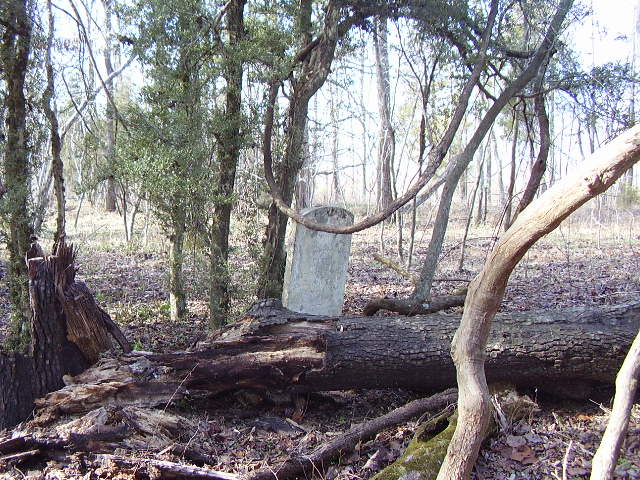
| Description | : | Family Cemetery on Private Property No Recorded Right of Public Access Property Owner's Permission Required This cemetery contains the gravestone of Mary Boyd Rice, wife of Stephen D. Rice. There may have been other graves which are now unidentifiable evidenced by broken stone fragments and depressions. The foundation of the homeplace is west of the cemetery in the same grove of trees. This family cemetery does not have a survey of record. In the vicinity of, across the highway from 12459 NC Hwy 150. Carolina Caswell identified this cemetery by USGS Topographic Map. Carolina Caswell conducted a photographic survey in January 2011. This... Read More |
frequently asked questions (FAQ):
-
Where is Rice Cemetery?
Rice Cemetery is located at NC Hwy 150 Ashland, Caswell County ,North Carolina ,USA.
-
Rice Cemetery cemetery's updated grave count on graveviews.com?
0 memorials
-
Where are the coordinates of the Rice Cemetery?
Latitude: 36.3270020
Longitude: -79.5245150
Nearby Cemetories:
1. Ware Family Cemetery
Ashland, Caswell County, USA
Coordinate: 36.3323080, -79.5118200
2. Paschal Family Cemetery
Ashland, Caswell County, USA
Coordinate: 36.3387660, -79.5214030
3. Apple Cemetery
Ashland, Caswell County, USA
Coordinate: 36.3442001, -79.5147018
4. Walker Family Cemetery
Ashland, Caswell County, USA
Coordinate: 36.3463450, -79.5271590
5. Fieldstone Drive Family Cemetery
Ashland, Caswell County, USA
Coordinate: 36.3261700, -79.4995400
6. Lambeth Family Cemetery
Camp Springs, Caswell County, USA
Coordinate: 36.3077030, -79.5116780
7. Smithey Cemetery
Lenox Castle, Rockingham County, USA
Coordinate: 36.3389470, -79.5490570
8. Norman Family Cemetery
Camp Springs, Caswell County, USA
Coordinate: 36.3129850, -79.5007770
9. Trinity Baptist Church Cemetery
Locust Hill, Caswell County, USA
Coordinate: 36.3418720, -79.4982020
10. Combs Family Cemetery
Ashland, Caswell County, USA
Coordinate: 36.3507430, -79.5102190
11. Somers Family Cemetery
Ashland, Caswell County, USA
Coordinate: 36.3508990, -79.5100950
12. Brown Family Cemetery
Camp Springs, Caswell County, USA
Coordinate: 36.3175200, -79.4922640
13. Trinity Old Baptist Church Cemetery
Locust Hill, Caswell County, USA
Coordinate: 36.3422660, -79.4955680
14. Pleasant Grove Primitive Baptist Church Cemetery
Ashland, Caswell County, USA
Coordinate: 36.3552780, -79.5119440
15. Beavers Family Cemetery
Ashland, Caswell County, USA
Coordinate: 36.3582000, -79.5071880
16. Family Cemetery on Apple Road
Camp Springs, Caswell County, USA
Coordinate: 36.2989100, -79.5002500
17. Walker-Somers Family Cemetery
Ashland, Caswell County, USA
Coordinate: 36.3595430, -79.5085820
18. Trinity Missionary Church Cemetery
Locust Hill, Caswell County, USA
Coordinate: 36.3477000, -79.4882000
19. Paschal-Butler Family Cemetery
Locust Hill, Caswell County, USA
Coordinate: 36.3403470, -79.4815830
20. Camp Springs United Methodist Church Cemetery
Camp Springs, Caswell County, USA
Coordinate: 36.2952766, -79.4972229
21. Camp Springs UMC Cemetery
Camp Springs, Caswell County, USA
Coordinate: 36.2930250, -79.5012760
22. Allen-Windsor Family Cemetery
Lenox Castle, Rockingham County, USA
Coordinate: 36.3553640, -79.5599870
23. Cobb Family Cemetery
Ashland, Caswell County, USA
Coordinate: 36.3676170, -79.5157610
24. Ashland Baptist Church Cemetery
Ashland, Caswell County, USA
Coordinate: 36.3651720, -79.5035180