
| Memorials | : | 176 |
| Location | : | Richland, Union County, USA |
| Coordinate | : | 42.7682991, -96.6624985 |
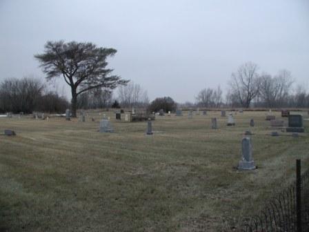
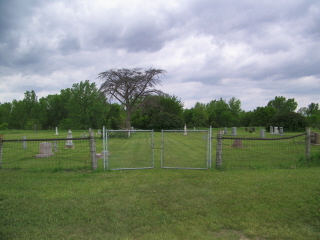
| Description | : | There is no sign or gate to mark this cemetery. Located approximately ½ mile North of Highway 50 on 477th Ave approximately ¼ mile in on east side of road on the north edge of where they used to mine for gravel. |
frequently asked questions (FAQ):
-
Where is Richland Cemetery?
Richland Cemetery is located at Richland, Union County ,South Dakota ,USA.
-
Richland Cemetery cemetery's updated grave count on graveviews.com?
3 memorials
-
Where are the coordinates of the Richland Cemetery?
Latitude: 42.7682991
Longitude: -96.6624985
Nearby Cemetories:
1. Saint Paul Cemetery
Elk Point, Union County, USA
Coordinate: 42.7641983, -96.7061005
2. Union County Poor Farm Cemetery
Union County, USA
Coordinate: 42.7649210, -96.7077580
3. First Brule Creek Cemetery
Elk Point, Union County, USA
Coordinate: 42.7943993, -96.7069016
4. Gores Bluff Cemetery
Union County, USA
Coordinate: 42.8035069, -96.6260468
5. Westfield Township Cemetery
Westfield, Plymouth County, USA
Coordinate: 42.7510986, -96.5914001
6. Mills Family Cemetery
Westfield, Plymouth County, USA
Coordinate: 42.7188460, -96.6019280
7. Brule Creek Cemetery
Spink Township, Union County, USA
Coordinate: 42.8346510, -96.7324350
8. Elk Point Cemetery
Elk Point, Union County, USA
Coordinate: 42.6794586, -96.6794586
9. Saint Joseph Cemetery
Elk Point, Union County, USA
Coordinate: 42.6794014, -96.6797028
10. Ahlsborg Lutheran Cemetery
Union County, USA
Coordinate: 42.8228000, -96.7612000
11. Pleasant Hill Cemetery Old
Spink, Union County, USA
Coordinate: 42.8588462, -96.7215592
12. Saint Patricks Cemetery
Akron, Plymouth County, USA
Coordinate: 42.8232300, -96.5374800
13. Pleasant Hill Cemetery
Spink, Union County, USA
Coordinate: 42.8741000, -96.6876000
14. Dowlin Cemetery
Burbank, Clay County, USA
Coordinate: 42.7789001, -96.8107986
15. Riverside Cemetery
Akron, Plymouth County, USA
Coordinate: 42.8367004, -96.5453033
16. Saint Mary Cemetery
Union County, USA
Coordinate: 42.8520584, -96.7877502
17. Union Creek Cemetery
Union County, USA
Coordinate: 42.8911018, -96.5863037
18. Saint Agnes Cemetery
Vermillion, Clay County, USA
Coordinate: 42.7872009, -96.8499985
19. Mount Hope Cemetery
Union County, USA
Coordinate: 42.8885994, -96.5667038
20. Ionia Cemetery
Newcastle, Dixon County, USA
Coordinate: 42.6893997, -96.8300018
21. Dewitt Cemetery
Ponca, Dixon County, USA
Coordinate: 42.6248000, -96.7437500
22. Gibb's Cemetery
Newcastle, Dixon County, USA
Coordinate: 42.6985100, -96.8518400
23. Elmwood Cemetery
Elk Point, Union County, USA
Coordinate: 42.6036700, -96.6881900
24. Nora Cemetery
Union County, USA
Coordinate: 42.9314003, -96.7061005