
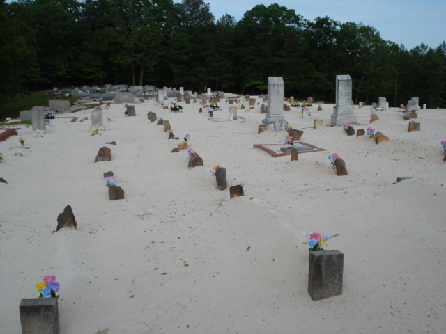
| Memorials | : | 0 |
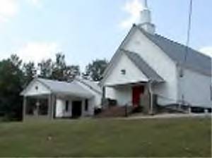
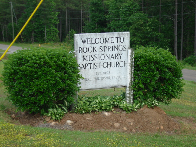
| Location | : | Ranburne, Cleburne County, USA |
| Coordinate | : | 33.4942017, -85.4360962 |
| Description | : | Township 17 Range 12 Section 31. To visit the cemetery, going via Cleburne County Highway 46, turn onto Cleburne County Road 10 South and continue 3 miles to Cleburne County Road 129, then turn left and, proceed for 1 mile. The cemetery is on the left. |
frequently asked questions (FAQ):
-
Where is Rock Springs Church Cemetery?
Rock Springs Church Cemetery is located at 1950 Cleburne County Road 129 Ranburne, Cleburne County ,Alabama , 36273USA.
-
Rock Springs Church Cemetery cemetery's updated grave count on graveviews.com?
0 memorials
-
Where are the coordinates of the Rock Springs Church Cemetery?
Latitude: 33.4942017
Longitude: -85.4360962
Nearby Cemetories:
1. Cool Springs United Methodist Church Cemetery
Randolph County, USA
Coordinate: 33.4904660, -85.4691480
2. Rice Cemetery
Randolph County, USA
Coordinate: 33.4612000, -85.4273100
3. Smyrna Missionary Cemetery
Randolph County, USA
Coordinate: 33.4607000, -85.4477000
4. Potter’s House Church Cemetery
Randolph County, USA
Coordinate: 33.4590498, -85.4251876
5. McLeod Family Cemetery
Randolph County, USA
Coordinate: 33.4598700, -85.4200700
6. Mountain View Baptist Church Cemetery
Ranburne, Cleburne County, USA
Coordinate: 33.5339410, -85.4279840
7. Pine Hill Christian Church Cemetery
Randolph County, USA
Coordinate: 33.4629700, -85.4025500
8. Gold Ridge Baptist Church Cemetery
Randolph County, USA
Coordinate: 33.4884200, -85.3861500
9. Pine Hill Church of Christ Cemetery
Randolph County, USA
Coordinate: 33.4460600, -85.4085100
10. Blake Cemetery
Ranburne, Cleburne County, USA
Coordinate: 33.4967900, -85.5024200
11. Harmony Congregational Methodist Church Cemetery
Newell, Randolph County, USA
Coordinate: 33.4413872, -85.4130554
12. Oak Grove A.M.E. Cemetery
Newell, Randolph County, USA
Coordinate: 33.4747120, -85.5006910
13. Union Hill Baptist Church Cemetery
Ranburne, Cleburne County, USA
Coordinate: 33.5401101, -85.3896742
14. Antioch Baptist Church Cemetery
Newell, Randolph County, USA
Coordinate: 33.4325430, -85.4383240
15. Jordan Chapel Methodist Church Cemetery
Newell, Randolph County, USA
Coordinate: 33.4576118, -85.4974540
16. Crumleys Chapel Cemetery
Trickem, Cleburne County, USA
Coordinate: 33.5564003, -85.4068985
17. Cleburne Memorial Gardens
Union Hill, Cleburne County, USA
Coordinate: 33.5367012, -85.3732986
18. Mount Gilead Baptist Church Cemetery
Newell, Randolph County, USA
Coordinate: 33.4239500, -85.4333100
19. Burden Cemetery
Newell, Randolph County, USA
Coordinate: 33.4225006, -85.4319458
20. Wise Chapel Cemetery
Trickem, Cleburne County, USA
Coordinate: 33.5691986, -85.4403000
21. Howle Family Cemetery
Cleburne County, USA
Coordinate: 33.5453987, -85.5084000
22. Ranburne First Baptist Church Cemetery
Ranburne, Cleburne County, USA
Coordinate: 33.5239983, -85.3452988
23. Hurricane Methodist Cemetery
Cleburne County, USA
Coordinate: 33.5656013, -85.4886017
24. Old Shiloh Church Cemetery
Graham, Randolph County, USA
Coordinate: 33.4488983, -85.3488998