
| Memorials | : | 0 |
| Location | : | Rockport, Aransas County, USA |
| Coordinate | : | 28.0000000, -96.9333333 |
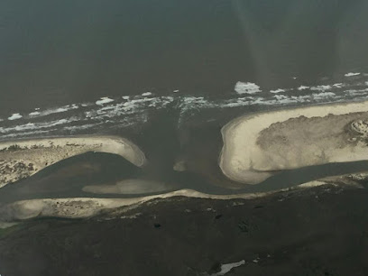
| Description | : | PLEASE NOTE, CURRENTLY THERE IS NO CITY NAMED CULEBRA OR ST. JOSEPH IN THE COUNTY OF ARANSAS. HOWEVER THERE WAS A CEMETERY ON THE ISLAND AT THE TIME IT WAS INHABITED AS DESCRIBED BELOW. ST. JOSEPH ISLAND ST. JOSEPH ISLAND. St. Joseph (San José) Island, whose center point is 28°00' north latitude and 96°56' west longitude, is a sand barrier island in Aransas County. It is separated from Matagorda Island on the north by Cedar Bayou and from Mustang Island on the south by Aransas Pass. St. Joseph Island is about twenty-one miles long and five miles wide. It protects Aransas... Read More |
frequently asked questions (FAQ):
-
Where is Saint Joseph Cemetery?
Saint Joseph Cemetery is located at Rockport, Aransas County ,Texas ,USA.
-
Saint Joseph Cemetery cemetery's updated grave count on graveviews.com?
0 memorials
-
Where are the coordinates of the Saint Joseph Cemetery?
Latitude: 28.0000000
Longitude: -96.9333333
Nearby Cemetories:
1. Rockport Cemetery
Rockport, Aransas County, USA
Coordinate: 28.0466347, -97.0363007
2. Fulton Cemetery
Fulton, Aransas County, USA
Coordinate: 28.0699348, -97.0389328
3. Wat Dhammaratanaram Buddhist Temple
Rockport, Aransas County, USA
Coordinate: 27.9973890, -97.0910230
4. Holy Cross Lutheran Church Memorial Wall
Rockport, Aransas County, USA
Coordinate: 28.0685030, -97.0719780
5. McLester Cemetery
Fulton, Aransas County, USA
Coordinate: 28.0541992, -97.0800018
6. Lamar Cemetery
Lamar, Aransas County, USA
Coordinate: 28.1427994, -96.9888992
7. Aransas Memorial Park Cemetery
Rockport, Aransas County, USA
Coordinate: 27.9715800, -97.1304100
8. Cementerio San Antonio de Padua
Aransas Pass, Aransas County, USA
Coordinate: 27.9367008, -97.1219025
9. Stiernberg Cemetery
Seadrift, Calhoun County, USA
Coordinate: 28.4008007, -96.6872025
10. Jordan
Long Mott, Calhoun County, USA
Coordinate: 28.4451850, -96.7541890
11. Sonneman Cemetery
Long Mott, Calhoun County, USA
Coordinate: 28.4556180, -96.7777280
12. Seadrift Cemetery
Seadrift, Calhoun County, USA
Coordinate: 28.4249992, -96.6892014
13. Long Mott Cemetery
Long Mott, Calhoun County, USA
Coordinate: 28.5024600, -96.7447230
14. Blanconia Methodist Cemetery
Blanconia, Bee County, USA
Coordinate: 28.3743910, -97.4086050
15. Matagorda Lighthouse Cemetery
Matagorda Island, Calhoun County, USA
Coordinate: 28.3451805, -96.4167023
16. McGuill Cemetery
Goliad County, USA
Coordinate: 28.4036007, -97.3949966
17. Taber Cemetery
Goliad, Goliad County, USA
Coordinate: 28.4036000, -97.3950000
18. Blanconia Baptist Church Cemetery
Blanconia, Bee County, USA
Coordinate: 28.4008640, -97.4111320
19. Papalote Protestant Cemetery
Papalote, Bee County, USA
Coordinate: 28.1711200, -97.5777730
20. Fort Esperanza Burying Ground
Matagorda Island, Calhoun County, USA
Coordinate: 28.3927000, -96.4120600
21. Port O'Connor Cemetery
Port O'Connor, Calhoun County, USA
Coordinate: 28.4344260, -96.4450480
22. Old Papalote Cemetery
Bee County, USA
Coordinate: 28.1616993, -97.6085968
23. Hatch Cemetery
Port Lavaca, Calhoun County, USA
Coordinate: 28.5885544, -96.7007141
24. Little Mary's Grave
Calhoun County, USA
Coordinate: 28.5748005, -96.6464767