
| Memorials | : | 0 |
| Location | : | Petroleum Center, Venango County, USA |
| Coordinate | : | 41.5205960, -79.6817780 |
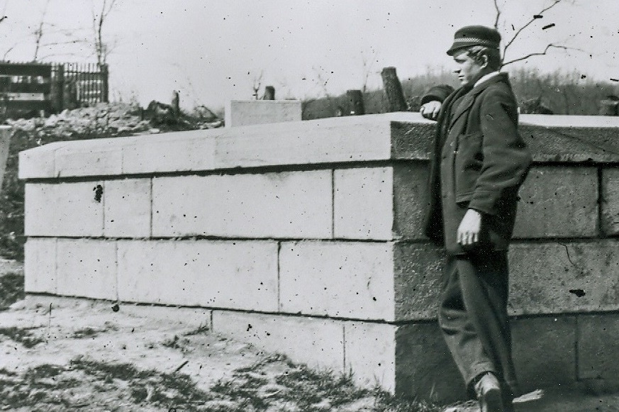
| Description | : | Adjacent to the Petroleum Centre Cemetery on the former Saint Peter and Paul RC Church grounds. About 250 feet up the hill from Petroleum Centre Road, on the right and about 50 feet into the woods was the Catholic Church and behind where the church was is a cut stone wall surrounding tombstones. This is the McClintock Cemetery. In 2009, the cemetery was in total neglect and disrepair. Heavily overgrown. The most noticeable land mark in the vicinty, is the large stone wall of the McClintock Cemetery. The 44 internments listed are from a list produced by Fr. Rerick, St. Venantius... Read More |
frequently asked questions (FAQ):
-
Where is Saint Peter and Paul Catholic Cemetery?
Saint Peter and Paul Catholic Cemetery is located at Oil Creek State Park Petroleum Center, Venango County ,Pennsylvania , 16301USA.
-
Saint Peter and Paul Catholic Cemetery cemetery's updated grave count on graveviews.com?
0 memorials
-
Where are the coordinates of the Saint Peter and Paul Catholic Cemetery?
Latitude: 41.5205960
Longitude: -79.6817780
Nearby Cemetories:
1. McClintock Cemetery
Venango County, USA
Coordinate: 41.5206000, -79.6802000
2. Irwin Cemetery
Petroleum Center, Venango County, USA
Coordinate: 41.5215220, -79.6806830
3. Petroleum Center Cemetery
Petroleum Center, Venango County, USA
Coordinate: 41.5216000, -79.6805000
4. Columbia Farm Cemetery
Petroleum Center, Venango County, USA
Coordinate: 41.4969900, -79.6878700
5. Bany-Brown-Stewart Cemetery
Oakland Township, Venango County, USA
Coordinate: 41.5253330, -79.7149170
6. Cherrytree Presbyterian Cemetery
Cherrytree Township, Venango County, USA
Coordinate: 41.5406100, -79.7124200
7. Kaneville Cemetery
Kaneville, Venango County, USA
Coordinate: 41.5101200, -79.7219900
8. Plumer Cemetery
Plumer, Venango County, USA
Coordinate: 41.5004800, -79.6453100
9. Rynd Farm Cemetery
Cornplanter Township, Venango County, USA
Coordinate: 41.4840800, -79.6955800
10. Tarr Farm Cemetery
Cherrytree Township, Venango County, USA
Coordinate: 41.5363860, -79.7298220
11. Oakland Seceder Cemetery
Oil City, Venango County, USA
Coordinate: 41.5045280, -79.7301010
12. Jamison Corners Cemetery
Cherrytree, Venango County, USA
Coordinate: 41.5692500, -79.6757300
13. Miller Farm Cemetery
Venango County, USA
Coordinate: 41.5651000, -79.6544000
14. Buxton Family Cemetery
Cherrytree, Venango County, USA
Coordinate: 41.5716000, -79.7099000
15. Lamey Cemetery
Fosters Corner, Venango County, USA
Coordinate: 41.4919014, -79.7455978
16. Shaw Farm Cemetery
Oil City, Venango County, USA
Coordinate: 41.4592018, -79.6697006
17. Oakland Evangelical Cemetery
Dempseytown, Venango County, USA
Coordinate: 41.5291700, -79.7664200
18. Dempseytown Lutheran Cemetery
Dempseytown, Venango County, USA
Coordinate: 41.5167000, -79.7764000
19. Dempsey Cemetery
Dempseytown, Venango County, USA
Coordinate: 41.5080000, -79.7790000
20. Dutch Hill Cemetery
Cherrytree, Venango County, USA
Coordinate: 41.6004000, -79.6685000
21. Breedtown Cemetery
Venango County, USA
Coordinate: 41.5998200, -79.7097500
22. Kerr Family Cemetery
Venango County, USA
Coordinate: 41.5935890, -79.7392420
23. Pithole Cemetery
Pithole City, Venango County, USA
Coordinate: 41.5214720, -79.5668060
24. Holmden Cemetery
Pithole City, Venango County, USA
Coordinate: 41.5214720, -79.5668050