| Memorials | : | 13 |
| Location | : | Sodra Lundby, Vara kommun, Sweden |
| Phone | : | +46(512)797200 |
| Website | : | www.svenskakyrkan.se/vara/sodra-lundby-kyrka-och-kyrkogard |
| Coordinate | : | 58.1958870, 13.0388570 |
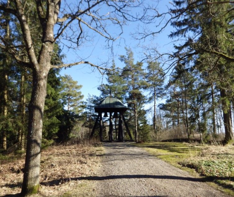
| Description | : | At the beginning of the 20th century, the old cemetery was considered to be fully occupied and instead of expanding, it was decided to build a new one about 1 km northwest of the church, at the old primary school. This was inaugurated in 1918 and in 1932 a belfry was erected on the site. |
frequently asked questions (FAQ):
-
Where is Södra Lundby Nya Kyrkogården?
Södra Lundby Nya Kyrkogården is located at Nya Kyrkogården Sodra Lundby, Vara kommun ,Västra Götalands län , 534 61Sweden.
-
Södra Lundby Nya Kyrkogården cemetery's updated grave count on graveviews.com?
0 memorials
-
Where are the coordinates of the Södra Lundby Nya Kyrkogården?
Latitude: 58.1958870
Longitude: 13.0388570
Nearby Cemetories:
1. Södra Lundby gamla kyrkogård
Sodra Lundby, Vara kommun, Sweden
Coordinate: 58.1887920, 13.0456000
2. Laske-Vedums kyrkogård
Vedum, Vara kommun, Sweden
Coordinate: 58.1717990, 12.9901200
3. Längjum Cemetery
Vara kommun, Sweden
Coordinate: 58.2149503, 13.1016114
4. Larvs kyrkogård
Larv, Vara kommun, Sweden
Coordinate: 58.1897710, 13.1156840
5. Tråvads Kyrkogård
Vara kommun, Sweden
Coordinate: 58.2457260, 13.0870450
6. Önum Kyrkogård
Vara, Vara kommun, Sweden
Coordinate: 58.2626400, 13.0053700
7. Naum Kyrkogård
Naum, Vara kommun, Sweden
Coordinate: 58.2394046, 12.9210738
8. Fyrunga Cemetery
Fyrunga, Vara kommun, Sweden
Coordinate: 58.2844180, 13.0938448
9. Södra Kedum Kyrkogård
Vara, Vara kommun, Sweden
Coordinate: 58.2396225, 12.8730965
10. Skarstad kyrkogård
Skarstad, Vara kommun, Sweden
Coordinate: 58.2956950, 13.0351750
11. Lekåsa Cemetery
Lekåsa, Essunga kommun, Sweden
Coordinate: 58.1393980, 12.8820870
12. Long Kyrkogård
Long, Vara kommun, Sweden
Coordinate: 58.2984400, 12.9601700
13. Barne-Åsaka
Essunga kommun, Sweden
Coordinate: 58.1418128, 12.8318773
14. Ryda kyrkogård
Ryda, Vara kommun, Sweden
Coordinate: 58.2868140, 12.8839170
15. Trävattna kyrkogård
Travattna, Falköpings kommun, Sweden
Coordinate: 58.1592120, 13.2650280
16. Eggvena Cemetery
Herrljunga kommun, Sweden
Coordinate: 58.0872283, 12.8934845
17. Essunga
Essunga kommun, Sweden
Coordinate: 58.1822346, 12.7838108
18. Jung kyrkogård
Jung, Vara kommun, Sweden
Coordinate: 58.3280660, 13.1174700
19. Hällestad Kyrkogård
Floby, Falköpings kommun, Sweden
Coordinate: 58.1090012, 13.2687868
20. Fåglums Nya Kyrkogård
Essunga kommun, Sweden
Coordinate: 58.1258998, 12.7792135
21. Fåglums gamla kyrkogård
Essunga kommun, Sweden
Coordinate: 58.1223601, 12.7757212
22. Källunga Kyrka
Källunga, Herrljunga kommun, Sweden
Coordinate: 58.0466660, 13.1684380
23. Bäreberg Cemetery
Essunga kommun, Sweden
Coordinate: 58.2067226, 12.7205270
24. Hyringa ödekyrkogård
Hyringa, Grästorps kommun, Sweden
Coordinate: 58.2926790, 12.7683480

