
| Memorials | : | 0 |
| Location | : | Fivemile Corner, Cotton County, USA |
| Coordinate | : | 34.4217400, -98.2429500 |
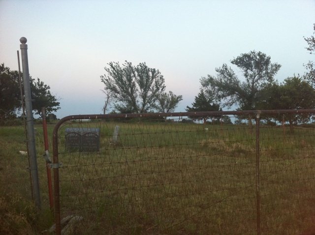
| Description | : | This cemetery is located in very rural Cotton County. It is located 4 miles north and one mile west of 5 Mile Corner - which is at the intersection of HWYs 53 and 65. There appear to be about 20 graves. About half of them marked only with plain granite fieldstones. The marked graves only take up less than 1/4 of the entire cemetery. |
frequently asked questions (FAQ):
-
Where is Shackelford Cemetery?
Shackelford Cemetery is located at Fivemile Corner, Cotton County ,Oklahoma ,USA.
-
Shackelford Cemetery cemetery's updated grave count on graveviews.com?
0 memorials
-
Where are the coordinates of the Shackelford Cemetery?
Latitude: 34.4217400
Longitude: -98.2429500
Nearby Cemetories:
1. Walters Cemetery
Walters, Cotton County, USA
Coordinate: 34.3666992, -98.3292007
2. Devine Cemetery
Geronimo, Comanche County, USA
Coordinate: 34.4926300, -98.3131400
3. Allendale Cemetery
Comanche County, USA
Coordinate: 34.4933014, -98.3143997
4. New Salem Cemetery
Cotton County, USA
Coordinate: 34.4047012, -98.3768997
5. Corum Cemetery
Stephens County, USA
Coordinate: 34.3697014, -98.1222000
6. Elm Grove Cemetery
Walters, Cotton County, USA
Coordinate: 34.4052400, -98.3778160
7. Eschiti Family Cemetery
Stephens County, USA
Coordinate: 34.4858100, -98.1263400
8. Letitia Cemetery
Lawton, Comanche County, USA
Coordinate: 34.5823500, -98.2119500
9. Temple Masonic Cemetery
Temple, Cotton County, USA
Coordinate: 34.2538986, -98.2358017
10. Crouch Cemetery
Lawton, Comanche County, USA
Coordinate: 34.5794100, -98.1625000
11. Rock Creek Cemetery
Duncan, Stephens County, USA
Coordinate: 34.5499992, -98.1055984
12. Oak Grove Cemetery
Empire City, Stephens County, USA
Coordinate: 34.4195300, -98.0350500
13. Diamond Cemetery
Stephens County, USA
Coordinate: 34.3319016, -98.0550003
14. Flower Mound Cemetery
Lawton, Comanche County, USA
Coordinate: 34.5790100, -98.3518600
15. Hastings Cemetery
Hastings, Jefferson County, USA
Coordinate: 34.2380981, -98.1232986
16. Saint Andrews Episcopal Church Columbarium
Lawton, Comanche County, USA
Coordinate: 34.6048400, -98.4086090
17. Duncan Municipal Cemetery
Duncan, Stephens County, USA
Coordinate: 34.4963989, -97.9738998
18. Fairlawn Cemetery
Comanche, Stephens County, USA
Coordinate: 34.3903008, -97.9589005
19. First United Methodist Church Columbarium
Lawton, Comanche County, USA
Coordinate: 34.6152870, -98.4261090
20. Highland Cemetery
Lawton, Comanche County, USA
Coordinate: 34.6319008, -98.4002991
21. First Christian Church Columbarium
Duncan, Stephens County, USA
Coordinate: 34.5027890, -97.9591140
22. Henderson-Harris Cemetery
Duncan, Stephens County, USA
Coordinate: 34.4716988, -97.9460983
23. Lone Star Cemetery
Hooper, Cotton County, USA
Coordinate: 34.1758080, -98.1758881
24. All Saints Episcopal Church Cemetery
Duncan, Stephens County, USA
Coordinate: 34.5116400, -97.9568600