
| Memorials | : | 0 |
| Location | : | Bulls Gap, Hawkins County, USA |
| Coordinate | : | 36.2997400, -82.9959200 |
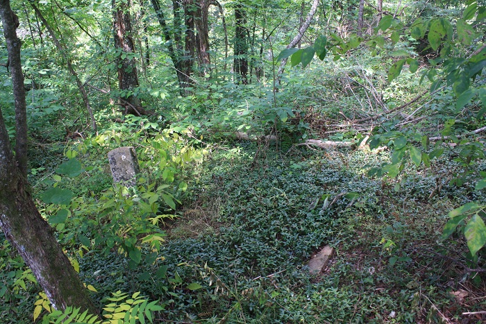
| Description | : | Described by a neighbor as the burial site of several Union officers, the site is located about 50 feet into the woods west of the house. Besides the memorial stone for Berryman Story, there are at least 4 field stone markers, some still standing. This site is on private property, seek permission before proceeding to the site and beware of snakes. |
frequently asked questions (FAQ):
-
Where is Short Road Civil War Burial Site?
Short Road Civil War Burial Site is located at Short Road Bulls Gap, Hawkins County ,Tennessee ,USA.
-
Short Road Civil War Burial Site cemetery's updated grave count on graveviews.com?
0 memorials
-
Where are the coordinates of the Short Road Civil War Burial Site?
Latitude: 36.2997400
Longitude: -82.9959200
Nearby Cemetories:
1. Couch Cemetery
Hawkins County, USA
Coordinate: 36.3025017, -83.0066986
2. Coward Cemetery
Hawkins County, USA
Coordinate: 36.2963982, -83.0124969
3. Dotson Cemetery
Hawkins County, USA
Coordinate: 36.3011017, -83.0141983
4. Speedwell Missionary Baptist Church Cemetery
Bulls Gap, Hawkins County, USA
Coordinate: 36.2897400, -83.0096100
5. Otes United Methodist Church Cemetery
Bulls Gap, Hawkins County, USA
Coordinate: 36.3128100, -83.0151400
6. Brotherton Cemetery
Greene County, USA
Coordinate: 36.2789001, -82.9800034
7. Pilot Knob Cemetery
Greene County, USA
Coordinate: 36.2711600, -82.9917500
8. Couch-Patterson Cemetery
Greene County, USA
Coordinate: 36.2971992, -82.9582977
9. Ed Berry Cemetery
Hawkins County, USA
Coordinate: 36.2983017, -83.0408020
10. Long and Berry Cemetery
Bulls Gap, Hawkins County, USA
Coordinate: 36.2931640, -83.0411480
11. Berry Cemetery
Bulls Gap, Hawkins County, USA
Coordinate: 36.3153000, -83.0408020
12. Everhart Cemetery
Greene County, USA
Coordinate: 36.3058014, -82.9431000
13. Starnes family cemetery
Romeo, Greene County, USA
Coordinate: 36.2911110, -82.9358330
14. Antioch United Methodist Church Cemetery
Mosheim, Greene County, USA
Coordinate: 36.2486040, -82.9983890
15. Chestnut Cemetery
Hawkins County, USA
Coordinate: 36.3414001, -83.0353012
16. Brown Cemetery
Greene County, USA
Coordinate: 36.2522011, -83.0271988
17. Trinity Pentecostal Church Cemetery
Bulls Gap, Hawkins County, USA
Coordinate: 36.2792650, -83.0636510
18. Carter Family Cemetery
Greeneville, Greene County, USA
Coordinate: 36.2851390, -82.9241610
19. Mount Carmel United Methodist Church Cemetery
Mosheim, Greene County, USA
Coordinate: 36.2508210, -82.9526230
20. Mount Sinai United Methodist Church Cemetery
Mosheim, Greene County, USA
Coordinate: 36.2405260, -82.9829440
21. Walker Cemetery
Bulls Gap, Hawkins County, USA
Coordinate: 36.3155400, -83.0680560
22. Price Cemetery
Baileyton, Greene County, USA
Coordinate: 36.2919360, -82.9192790
23. Burns Cemetery
Hawkins County, USA
Coordinate: 36.3499985, -82.9308014
24. Cedar Grove Cemetery
Austins Mill, Hawkins County, USA
Coordinate: 36.3731500, -83.0021060