
| Memorials | : | 0 |
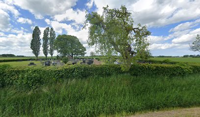
| Location | : | Sint Annen, Ten Boer Municipality, Netherlands |
| Coordinate | : | 53.2965300, 6.6592300 |
frequently asked questions (FAQ):
-
Where is Sint Annen Begraafplaats?
Sint Annen Begraafplaats is located at Sint Annen, Ten Boer Municipality ,Groningen ,Netherlands.
-
Sint Annen Begraafplaats cemetery's updated grave count on graveviews.com?
0 memorials
-
Where are the coordinates of the Sint Annen Begraafplaats?
Latitude: 53.2965300
Longitude: 6.6592300
Nearby Cemetories:
1. Thesinge Begraafplaats
Thesinge, Ten Boer Municipality, Netherlands
Coordinate: 53.2721400, 6.6550500
2. Ten Boer Protestant Cemetery
Ten Boer, Ten Boer Municipality, Netherlands
Coordinate: 53.2781900, 6.6933300
3. Stedum Cemetery
Stedum, Loppersum Municipality, Netherlands
Coordinate: 53.3251900, 6.6873400
4. Bedum Algemene Begraafplaats
Bedum, Bedum Municipality, Netherlands
Coordinate: 53.2969400, 6.6033200
5. Westerwijtwerd Churchyard
Westerwijtwerd, Loppersum Municipality, Netherlands
Coordinate: 53.3339900, 6.6444100
6. Algemene Begraafplaats Woltershof
Woltersum, Ten Boer Municipality, Netherlands
Coordinate: 53.2707171, 6.7271028
7. Middelstum Cemetery
Middelstum, Loppersum Municipality, Netherlands
Coordinate: 53.3443200, 6.6451600
8. Ten Post Begraafplaats
Ten Post, Ten Boer Municipality, Netherlands
Coordinate: 53.2909200, 6.7434400
9. Saint Hippolytus Churchyard
Middelstum, Loppersum Municipality, Netherlands
Coordinate: 53.3477817, 6.6412390
10. Wittewierum Kerkhof
Wittewierum, Ten Boer Municipality, Netherlands
Coordinate: 53.2876700, 6.7479300
11. Noorddijk General Cemetery
Noorddijk, Groningen Municipality, Netherlands
Coordinate: 53.2434500, 6.6258200
12. Toornwerd Begraafplaats
Toornwerd, Loppersum Municipality, Netherlands
Coordinate: 53.3538400, 6.6360700
13. Loppersum General Cemetery
Loppersum, Loppersum Municipality, Netherlands
Coordinate: 53.3307500, 6.7485600
14. Kantens Algemene begraafplaats
Kantens, Eemsmond Municipality, Netherlands
Coordinate: 53.3662600, 6.6333800
15. Sauwerd New Cemetery
Sauwerd, Winsum Municipality, Netherlands
Coordinate: 53.2975400, 6.5357900
16. Joodse Begraafplaats Iepenlaan
Groningen, Groningen Municipality, Netherlands
Coordinate: 53.2402780, 6.5544440
17. Selwerderhof Cemetery
Groningen, Groningen Municipality, Netherlands
Coordinate: 53.2394500, 6.5534100
18. Bellingeweer Cemetery
Bellingeweer, Winsum Municipality, Netherlands
Coordinate: 53.3253200, 6.5182100
19. Crematorium Groningen
Groningen, Groningen Municipality, Netherlands
Coordinate: 53.2383066, 6.5448000
20. Zandeweer Algemene Begraafplaats
Zandeweer, Eemsmond Municipality, Netherlands
Coordinate: 53.3858400, 6.6801400
21. Groningen Noorderbegraafplaats
Groningen, Groningen Municipality, Netherlands
Coordinate: 53.2305500, 6.5523300
22. Begraafplaats Wierum
Wierumerschouw, Zuidhorn Municipality, Netherlands
Coordinate: 53.2683085, 6.5122962
23. Joodse Begraafplaats Moesstraat
Groningen, Groningen Municipality, Netherlands
Coordinate: 53.2305560, 6.5505560
24. Winsum General Cemetery
Winsum, Winsum Municipality, Netherlands
Coordinate: 53.3280100, 6.5121400