
| Memorials | : | 0 |
| Location | : | Toornwerd, Loppersum Municipality, Netherlands |
| Coordinate | : | 53.3538400, 6.6360700 |
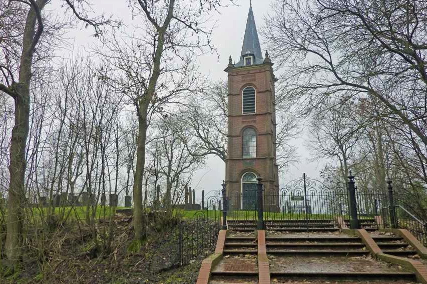
| Description | : | The cemetery of the small country village of Toornwerd, located in the northern part of the Dutch northeastern province Groningen, was constructed at the highest point of Toornwerd's so-called wier(de), a large artificial mound of about 14 feet high, to which the people and animals could flee in the Middleages and before during very high sea spring tides from the north when it stormed hard. The tower at the cemetery is a remnant of a chapel. Toornwerd means "with thorns covered wier(de)". |
frequently asked questions (FAQ):
-
Where is Toornwerd Begraafplaats?
Toornwerd Begraafplaats is located at Toornwerd, Loppersum Municipality ,Groningen ,Netherlands.
-
Toornwerd Begraafplaats cemetery's updated grave count on graveviews.com?
0 memorials
-
Where are the coordinates of the Toornwerd Begraafplaats?
Latitude: 53.3538400
Longitude: 6.6360700
Nearby Cemetories:
1. Saint Hippolytus Churchyard
Middelstum, Loppersum Municipality, Netherlands
Coordinate: 53.3477817, 6.6412390
2. Middelstum Cemetery
Middelstum, Loppersum Municipality, Netherlands
Coordinate: 53.3443200, 6.6451600
3. Kantens Algemene begraafplaats
Kantens, Eemsmond Municipality, Netherlands
Coordinate: 53.3662600, 6.6333800
4. Westerwijtwerd Churchyard
Westerwijtwerd, Loppersum Municipality, Netherlands
Coordinate: 53.3339900, 6.6444100
5. Zandeweer Algemene Begraafplaats
Zandeweer, Eemsmond Municipality, Netherlands
Coordinate: 53.3858400, 6.6801400
6. Stedum Cemetery
Stedum, Loppersum Municipality, Netherlands
Coordinate: 53.3251900, 6.6873400
7. Usquert General Cemetery
Usquert, Eemsmond Municipality, Netherlands
Coordinate: 53.4045800, 6.6109600
8. Israëlitische Begraafplaats
Uithuizen, Eemsmond Municipality, Netherlands
Coordinate: 53.4058100, 6.6701800
9. Uithuizen Roman Catholic Cemetery
Uithuizen, Eemsmond Municipality, Netherlands
Coordinate: 53.4068300, 6.6664800
10. Uithuizen Old General Cemetery
Uithuizen, Eemsmond Municipality, Netherlands
Coordinate: 53.4069400, 6.6704800
11. Sint Annen Begraafplaats
Sint Annen, Ten Boer Municipality, Netherlands
Coordinate: 53.2965300, 6.6592300
12. Bedum Algemene Begraafplaats
Bedum, Bedum Municipality, Netherlands
Coordinate: 53.2969400, 6.6033200
13. Warffum Communal Cemetery
Warffum, Eemsmond Municipality, Netherlands
Coordinate: 53.3935400, 6.5585300
14. Baflo Cemetery
Baflo, Winsum Municipality, Netherlands
Coordinate: 53.3622100, 6.5232900
15. Uithuizermeeden General Cemetery
Uithuizermeeden, Eemsmond Municipality, Netherlands
Coordinate: 53.4080100, 6.7117200
16. Loppersum General Cemetery
Loppersum, Loppersum Municipality, Netherlands
Coordinate: 53.3307500, 6.7485600
17. Bellingeweer Cemetery
Bellingeweer, Winsum Municipality, Netherlands
Coordinate: 53.3253200, 6.5182100
18. Winsum General Cemetery
Winsum, Winsum Municipality, Netherlands
Coordinate: 53.3280100, 6.5121400
19. Den Andel Protestant Cemetery
Den Andel, Winsum Municipality, Netherlands
Coordinate: 53.3855700, 6.5096200
20. Sauwerd New Cemetery
Sauwerd, Winsum Municipality, Netherlands
Coordinate: 53.2975400, 6.5357900
21. Thesinge Begraafplaats
Thesinge, Ten Boer Municipality, Netherlands
Coordinate: 53.2721400, 6.6550500
22. Ten Boer Protestant Cemetery
Ten Boer, Ten Boer Municipality, Netherlands
Coordinate: 53.2781900, 6.6933300
23. 't Zandt Algemene Begraafplaats
't Zandt, Loppersum Municipality, Netherlands
Coordinate: 53.3627600, 6.7759900
24. Maarhuizen Cemetery
Maarhuizen, Winsum Municipality, Netherlands
Coordinate: 53.3418900, 6.4917700