
| Memorials | : | 0 |
| Location | : | Ludowici, Long County, USA |
| Coordinate | : | 31.8227820, -81.7755750 |
frequently asked questions (FAQ):
-
Where is Smith Family Cemetery?
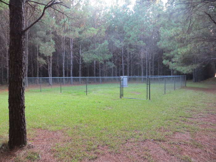
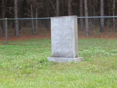
Smith Family Cemetery is located at Garland Smith Lane (Rye Patch Community) Ludowici, Long County ,Georgia , 31316USA.
-
Smith Family Cemetery cemetery's updated grave count on graveviews.com?
0 memorials
-
Where are the coordinates of the Smith Family Cemetery?
Latitude: 31.8227820
Longitude: -81.7755750
Nearby Cemetories:
1. Rye Patch Church Cemetery
Ludowici, Long County, USA
Coordinate: 31.8137000, -81.7764400
2. New Poplar Head Church Cemetery
Donald, Long County, USA
Coordinate: 31.8668700, -81.7909500
3. Liberty Baptist Church Cemetery
Hinesville, Liberty County, USA
Coordinate: 31.8598540, -81.7238940
4. Macedonia Cemetery
Long County, USA
Coordinate: 31.8489400, -81.8464520
5. New Church of Christ of the Apostolic Fairh
Long County, USA
Coordinate: 31.7588100, -81.7470169
6. Jones Creek Baptist Church Cemetery
Ludowici, Long County, USA
Coordinate: 31.7560444, -81.8115005
7. Memorial Gardens Jones Creek Baptist Church
Ludowici, Long County, USA
Coordinate: 31.7560300, -81.8115000
8. Saint Thomas Missionary Baptist Church Cemetery
Long County, USA
Coordinate: 31.8058930, -81.8631150
9. Wells Cemetery
Gum Branch, Liberty County, USA
Coordinate: 31.8431000, -81.6786000
10. Elim Baptist Church Cemetery
Ludowici, Long County, USA
Coordinate: 31.7888500, -81.6823300
11. Barrett Cemetery
Ludowici, Long County, USA
Coordinate: 31.7667007, -81.6952972
12. Poplar Head Cemetery
Fort Stewart, Long County, USA
Coordinate: 31.9081000, -81.8139000
13. Little Rock Baptist Church Cemetery
Ludowici, Long County, USA
Coordinate: 31.8782540, -81.8705940
14. Saint Luke Missionary Baptist Church Cemetery
Hinesville, Liberty County, USA
Coordinate: 31.8085390, -81.6598060
15. Faith Memorial Garden
Hinesville, Liberty County, USA
Coordinate: 31.8117000, -81.6495000
16. Poppell Cemetery
Hinesville, Liberty County, USA
Coordinate: 31.8143997, -81.6492004
17. Pigot Branch Missionary Baptist Church Cemetery
Long County, USA
Coordinate: 31.8318280, -81.9052600
18. Grace Baptist Church Cemetery
Long County, USA
Coordinate: 31.8359610, -81.9082680
19. Concord Cemetery
Long County, USA
Coordinate: 31.7317009, -81.6883011
20. Sand Hill Cemetery
Long County, USA
Coordinate: 31.9139290, -81.8684620
21. Gaps of the Bays Cemetery
Long County, USA
Coordinate: 31.9333000, -81.8368988
22. Zion Travel Cemetery
Fort Stewart, Long County, USA
Coordinate: 31.9216995, -81.8625031
23. Smith Chapel Cemetery
Fort Stewart, Long County, USA
Coordinate: 31.9356003, -81.8460999
24. Congregational Cemetery
Fort Stewart, Long County, USA
Coordinate: 31.9367008, -81.8469009