
| Memorials | : | 0 |
| Location | : | Fort Stewart, Long County, USA |
| Coordinate | : | 31.9367008, -81.8469009 |
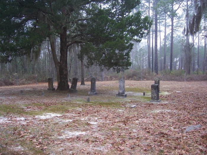
| Description | : | Congregational cemetery is located in Long County at Fort Stewart Military Reservation. The cemetery is located in Fort Stewart Training Area E13, north of highway 144 east of Fort Stewart Road #5. There are 7 marked and 2 unmarked graves. |
frequently asked questions (FAQ):
-
Where is Congregational Cemetery?
Congregational Cemetery is located at Fort Stewart, Long County ,Georgia ,USA.
-
Congregational Cemetery cemetery's updated grave count on graveviews.com?
0 memorials
-
Where are the coordinates of the Congregational Cemetery?
Latitude: 31.9367008
Longitude: -81.8469009
Nearby Cemetories:
1. Smith Chapel Cemetery
Fort Stewart, Long County, USA
Coordinate: 31.9356003, -81.8460999
2. Gaps of the Bays Cemetery
Long County, USA
Coordinate: 31.9333000, -81.8368988
3. Zion Travel Cemetery
Fort Stewart, Long County, USA
Coordinate: 31.9216995, -81.8625031
4. Sand Hill Cemetery
Long County, USA
Coordinate: 31.9139290, -81.8684620
5. Poplar Head Cemetery
Fort Stewart, Long County, USA
Coordinate: 31.9081000, -81.8139000
6. Little Rock Baptist Church Cemetery
Ludowici, Long County, USA
Coordinate: 31.8782540, -81.8705940
7. Bethel Church Cemetery
Fort Stewart, Liberty County, USA
Coordinate: 31.9799995, -81.7727966
8. New Poplar Head Church Cemetery
Donald, Long County, USA
Coordinate: 31.8668700, -81.7909500
9. Macedonia Cemetery
Long County, USA
Coordinate: 31.8489400, -81.8464520
10. Grace Baptist Church Cemetery
Long County, USA
Coordinate: 31.8359610, -81.9082680
11. Pigot Branch Missionary Baptist Church Cemetery
Long County, USA
Coordinate: 31.8318280, -81.9052600
12. Todd-Ray Cemetery
Fort Stewart, Liberty County, USA
Coordinate: 31.9978008, -81.7138977
13. Smith Family Cemetery
Ludowici, Long County, USA
Coordinate: 31.8227820, -81.7755750
14. Liberty Baptist Church Cemetery
Hinesville, Liberty County, USA
Coordinate: 31.8598540, -81.7238940
15. Saint Thomas Missionary Baptist Church Cemetery
Long County, USA
Coordinate: 31.8058930, -81.8631150
16. Rye Patch Church Cemetery
Ludowici, Long County, USA
Coordinate: 31.8137000, -81.7764400
17. Porter Cemetery
Liberty County, USA
Coordinate: 32.0191550, -81.6802200
18. Green Cypress Missionary Baptist Church Cemetery
Evans County, USA
Coordinate: 32.0995420, -81.8756250
19. Barnard Cemetery
Evans County, USA
Coordinate: 32.1025009, -81.8668976
20. Union United Methodist Church Cemetery
Claxton, Evans County, USA
Coordinate: 32.0971985, -81.9067001
21. Taylors Creek Cemetery
Fort Stewart, Liberty County, USA
Coordinate: 31.9356003, -81.6481018
22. Antioch Missionary Baptist Church Cemetery
Claxton, Evans County, USA
Coordinate: 32.1055984, -81.8367004
23. Wells Cemetery
Gum Branch, Liberty County, USA
Coordinate: 31.8431000, -81.6786000
24. Salem Cemetery
Fort Stewart, Liberty County, USA
Coordinate: 32.0772018, -81.7305984