
| Memorials | : | 0 |
| Location | : | Gorgas, Walker County, USA |
| Coordinate | : | 33.5724950, -87.2183230 |
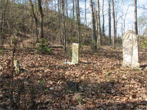
| Description | : | University of Alabama Cemetery and Graves Identification Cemetery #256 T17S, R7W, Sec12 Turn from Tutwiler Road onto Taylors Ferry Road and follow until you are able to see the back water of Warrior River on the left side of road. You will make a right turn into an open area at this point. Look straight and you should see a sign nailed into a tree that states "Snow Cemetery". Go past this sign into the wooded area and follow old logging road and make a left bend up a small hill and you will see another Snow Cemetery sign on the left... Read More |
frequently asked questions (FAQ):
-
Where is Snow-Thompson Cemetery?
Snow-Thompson Cemetery is located at Gorgas, Walker County ,Alabama ,USA.
-
Snow-Thompson Cemetery cemetery's updated grave count on graveviews.com?
0 memorials
-
Where are the coordinates of the Snow-Thompson Cemetery?
Latitude: 33.5724950
Longitude: -87.2183230
Nearby Cemetories:
1. Richardson Cemetery
Tutwiler, Walker County, USA
Coordinate: 33.5414320, -87.2228620
2. Heard Shoals Cemetery
Tutwiler, Walker County, USA
Coordinate: 33.5356653, -87.2480550
3. Pleasant Hill Baptist Church Cemetery
Bessemer, Jefferson County, USA
Coordinate: 33.5261650, -87.1946560
4. Brake Cemetery
Pumpkin Center, Walker County, USA
Coordinate: 33.6154670, -87.1830830
5. Cedar Creek Church of Christ Cemetery
Tutwiler, Walker County, USA
Coordinate: 33.5939990, -87.2791670
6. High Hill Church Cemetery
Littletons, Walker County, USA
Coordinate: 33.6191580, -87.2604320
7. Miller Cemetery
Littletons, Walker County, USA
Coordinate: 33.6161003, -87.2694016
8. Busby Cemetery
Littletons, Walker County, USA
Coordinate: 33.6286011, -87.2497025
9. Dug Hill Cemetery
Oak Grove, Jefferson County, USA
Coordinate: 33.5219002, -87.1699982
10. Franklin Cemetery
Goodsprings, Walker County, USA
Coordinate: 33.6422005, -87.2244034
11. Waiting Place Cemetery
Pumpkin Center, Walker County, USA
Coordinate: 33.6331570, -87.1765400
12. Vines Cemetery
Alliance, Jefferson County, USA
Coordinate: 33.5352880, -87.1464100
13. Starview Baptist Cemetery
Littletons, Walker County, USA
Coordinate: 33.6254030, -87.2743570
14. Rowe Cemetery
Cedar Lake, Walker County, USA
Coordinate: 33.6281013, -87.2789001
15. Short Cemetery
Gorgas, Walker County, USA
Coordinate: 33.6466490, -87.2006700
16. Big Creek Baptist Church Cemetery
Oak Grove, Jefferson County, USA
Coordinate: 33.4936840, -87.2159350
17. Caradine Cemetery
Littletons, Walker County, USA
Coordinate: 33.6336390, -87.2796710
18. Sunset Cemetery
Pumpkin Center, Walker County, USA
Coordinate: 33.6416650, -87.1572520
19. Oak Grove Church of Christ Cemetery
Pumpkin Center, Walker County, USA
Coordinate: 33.6395300, -87.1506500
20. Smithville Baptist Church Cemetery
Bessemer, Jefferson County, USA
Coordinate: 33.4993180, -87.1556320
21. Liberty Cemetery
Alliance, Jefferson County, USA
Coordinate: 33.5423000, -87.1164400
22. Praco Cemetery
Birmingham, Jefferson County, USA
Coordinate: 33.6130110, -87.1211640
23. Goodsprings Church of Christ Cemetery
Goodsprings, Walker County, USA
Coordinate: 33.6628780, -87.2289130
24. Atwood Cemetery
Jefferson County, USA
Coordinate: 33.5847015, -87.1102982